Creates a series of image tiles that can be utilized by web mapping applications such as Bing™ Maps, Google Maps™, or Web Map Tile Service. This is done by resampling rasters to various different resolutions and then splitting them into tiles.
Input Ports
Features with raster geometry.
Output Ports
The resulting image tiles.
Parameters
Specifies a method for tiling up data. This controls factors like the coordinate system, tile size, spacing, etc. See the Tile Schemes section for more details.
These parameters specify the zoom levels for which tiles will be generated. The exact meaning of a zoom level depends on the tile scheme, but in general a higher zoom level uses more pixels to cover the same area (i.e. more tiles will be generated).
If Minimum Zoom Level is unspecified, the minimum zoom level will default to the minimum level at which the raster is visible. Note that tiles will not be generated if the input raster covers less than 1 row and 1 column at a particular zoom level, regardless of the minimum zoom level value.
These parameters specify the zoom levels for which tiles will be generated. The exact meaning of a zoom level depends on the tile scheme, but in general a higher zoom level uses more pixels to cover the same area (i.e. more tiles will be generated).
If Maximum Zoom Level is unspecified, the maximum zoom level will be the smallest zoom level such that the resampled raster has more rows or columns than the original raster.
These parameters specify the size of each output tile for tile schemes that support user-defined sizes.
These parameters specify the size of each output tile for tile schemes that support user-defined sizes.
Cell values are interpolated in order to change the raster to the specified size. You can choose from these interpolation methods.
- Nearest Neighbor is the fastest but produces the poorest image quality.
- Bilinear provides a reasonable balance of speed and quality.
- Bicubic is the slowest but produces the best image quality.
- Average 4 and Average 16 have a performance similar to Bilinear and are useful for numeric rasters such as DEMs.
If specified, an attribute will be added to each output feature specifying the quadkey for that tile. Quadkeys are used by Bing Maps to uniquely identify a single tile at a particular level of detail. Note that this attribute will only be created for quad-tree based tile schemes (GoogleMapsCompatible and GoogleCRS84Quad).
If specified, an attribute will be added to each output feature specifying the zoom level of that tile.
If specified, an attribute will be added to each output feature specifying the column of that tile.
If specified, an attribute will be added to each output feature specifying the row of that tile.
If specified, an attribute will be added to each output feature that identifies which raster it was created from. This index is zero-based, so all tiles created from the first input raster will have a value of 0, all tiles created from the second input raster will have a value of 1, etc.
If specified, an attribute will be added to each output feature identifying the total number of tiles created from the input raster, across all zoom levels.
Tile Schemes
This scheme is used by Google Maps, Bing Maps, Web Map Tile Service, and ArcGIS.
- Input rasters are required to be in the EPSG:3857 coordinate system.
- Tiles are always 256x256 pixels.
- Valid zoom levels are 0 to 23.
- At level 0, the entire world is represented by a 256x256 pixel tile. Each level increases the number of rows and columns by a factor of two: level 1 is 512x512, level 2 is 1024x1024, etc.
- The ExpressionEvaluator transformer can be used to setup tile numbering.
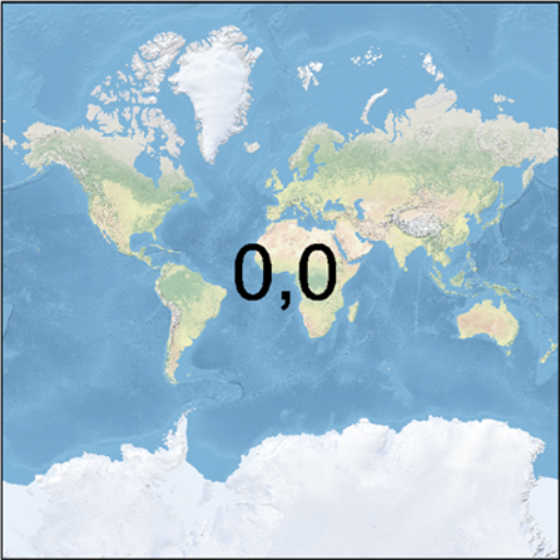
GoogleMapsCompatible zoom level 0 tiles (column, row):

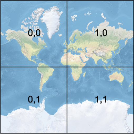
GoogleMapsCompatible zoom level 1 tiles:

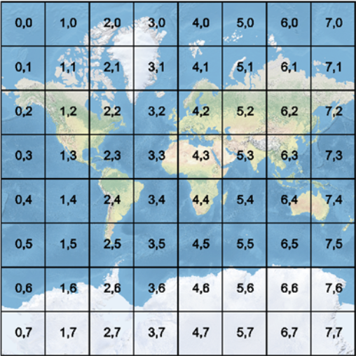
GoogleMapsCompatible zoom level 3 tiles:

This scheme is used by Web Map Tile Service.
- Input rasters are required to be in the LL84 coordinate system.
- Tiles are always 256x256 pixels.
- Valid zoom levels are 0 to 18.
- At level 0, the entire world is represented by a 256x256 pixel tile (where the first and last 64 rows of the tile are blank). Each level increases the number of rows and columns by a factor of two: level 1 is 512x512, level 2 is 1024x1024, etc.
- The ExpressionEvaluator transformer can be used to setup tile numbering.
This scheme is used by Web Map Tile Service.
- Input rasters are required to be in the LL84 coordinate system.
- Tiles may have a user-defined size.
- Valid zoom levels are 0 to 20.
- This scheme defines a spacing in degrees for each level, as follows:
| Level | Spacing (degrees) |
|---|---|
| 0 | 1.25764139776733 |
| 1 | 0.628820698883665 |
| 2 | 0.251528279553466 |
| 3 | 0.125764139776733 |
| 4 | 6.28820698883665e-2 |
| 5 | 2.51528279553466e-2 |
| 6 | 1.25764139776733e-2 |
| 7 | 6.28820698883665e-3 |
| 8 | 2.51528279553466e-3 |
| 9 | 1.25764139776733e-3 |
| 10 | 6.28820698883665e-4 |
| 11 | 2.51528279553466e-4 |
| 12 | 1.25764139776733e-4 |
| 13 | 6.28820698883665e-5 |
| 14 | 2.51528279553466e-5 |
| 15 | 1.25764139776733e-5 |
| 16 | 6.28820698883665e-6 |
| 17 | 2.51528279553466e-6 |
| 18 | 1.25764139776733e-6 |
| 19 | 6.28820698883665e-7 |
| 20 | 2.51528279553466e-7 |
This scheme is used by Web Map Tile Service.
- Input rasters are required to be in the LL84 coordinate system.
- Tiles may have a user-defined size.
- Valid zoom levels are 0 to 17.
- This scheme defines a spacing in degrees for each level, as follows:
| Level | Spacing (degrees) |
|---|---|
| 0 | 2 |
| 1 | 1 |
| 2 | 0.5 |
| 3 | 0.333333333333333 |
| 4 | 0.166666666666667 |
| 5 | 8.333333333333333e-2 |
| 6 | 3.333333333333333e-2 |
| 7 | 1.666666666666667e-2 |
| 8 | 8.333333333333333e-3 |
| 9 | 4.166666666666667e-3 |
| 10 | 1.388888888888889e-3 |
| 11 | 8.333333333333333e-4 |
| 12 | 2.777777777777778e-4 |
| 13 | 1.388888888888889e-4 |
| 14 | 8.333333333333333e-5 |
| 15 | 2.777777777777778e-5 |
| 16 | 8.333333333333333e-6 |
| 17 | 2.777777777777778e-6 |
Usage Notes
- Generally, when writing out the rasters generated by this transformer, one would fanout the destination feature type on the quadkey for Bing Maps or a combination of the zoom level, tile column, and tile row for Google Maps. The PNGRASTER writer is recommended for the best results.
- This transformer accepts only features that have raster geometry and is unaffected by raster band and/or palette subselection.
- Note that for the best performance, rasters output by this transformer should be written in the order they are output. Changing the order, e.g. by using Dataset Fanout or a Sorter transformer, may negatively impact performance. Alternatively, use a RasterCheckpointer after the WebMapTiler, but prior to the operation that changes the order.
Editing Transformer Parameters
Using a set of menu options, transformer parameters can be assigned by referencing other elements in the workspace. More advanced functions, such as an advanced editor and an arithmetic editor, are also available in some transformers. To access a menu of these options, click  beside the applicable parameter. For more information, see Transformer Parameter Menu Options.
Transformer Categories
FME Licensing Level
FME Professional edition and above
Transformer History
This transformer was previously named the VirtualEarthTiler.
Search FME Knowledge Center
Search for samples and information about this transformer on the FME Knowledge Center.
Tags Keywords: raster grid band "virtual earth" Bing Google "web map" webmap mapcruncher pyramid clip tile subset quadkey VirtualEarthTiler