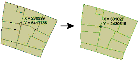
Reprojects feature coordinates from one coordinate system to another.
Parameters
If the feature had a coordinate system, that system is used as the source of the reprojection, and the Source Coordinate System parameter to this transformer is ignored.
If the feature did not have a source coordinate system, and the Source Coordinate System parameter was unset, then the transformer only sets the coordinate system of the feature to the destination coordinate system, and the coordinates of the feature remain unchanged.
Note: If the source coordinate system is not fixed and may change from feature to feature, and the features themselves have been tagged with a coordinate system from the reader that produced them, then a single Reprojector may still be able to be used. In such a case, both the source and destination coordinate system can be set to the same value – the destination coordinate system – and the desired behavior will be accomplished.
If this parameter is set to No, then only the center points of the arcs or ellipses will be reprojected. Otherwise, if the feature came from a reader which supported this option, the arcs are converted to lines and ellipses to polygons and then reprojected. This option is has no effect on advanced geometry arcs and ellipses.
The Interpolation Type affects only raster data. Cell values are interpolated in order to change the raster to the specified size.
- Nearest Neighbor is the fastest but produces the poorest image quality.
- Bilinear provides a reasonable balance of speed and quality.
- Bicubic is the slowest but produces the best image quality.
- Average 4 and Average 16 have a performance similar to Bilinear and are useful for numeric rasters such as DEMs.
The Cell Size applies only to raster features.
- Stretch Cells: The cell size of the raster will be adjusted to maintain the same number of rows and columns in the reprojected raster as there were in the input raster.
- Square Cells: The number of rows and columns as well as the spacing will be changed to maintain approximately the same cell ground area and form square cells where the horizontal and vertical cell sizes are equal. Like the Square Cells option, Preserve Cells will change both the number of rows and columns and the spacing to maintain cell ground area, but will also try to preserve the original cell aspect ratio, taking into account any warping caused by the reprojection.
- Preserve Cells: Like the Square Cells option, this option will change both the number of rows and columns and the spacing to maintain cell ground area, but will also try to preserve the original cell aspect ratio, taking into account any warping caused by the reprojection.
If the destination coordinate system is specified as "_AZMEA_" or "_AZMED_", each input feature is reprojected to either an equal area or equal distance projection appropriate for that feature, respectively. In general, this causes a new coordinate system to be defined for each input feature.
Each feature remembers which specific equal distance or equal area coordinate system it has, and can be safely reprojected back to a normal (non-dynamic) coordinate system.
As an example:
- There is an input feature representing a point on the earth in LL-WGS84 (normal lat/long).
- The point is reprojected to _AZMED_ via a Reprojector with source LL-WGS84 and destination _AZMED_.
- The x and y coordinates of the point are extracted into x1, y1.
- Set x2 = x1 + 1000, and y2 = y1.
- Add a vertex to the point to make the line (x1,y1) -> (x2,y2).
- Reproject back to LL-WGS84 via a Reprojector with source _AZMED_ and destination LL-WGS84.
Note: Note that the source is ignored here. We just chose _AZMED_ to help remember what is going on. Sometimes people prefer to set the source and destination both to LL-WGS84.
- Now we have changed our point into a line extending 1 km east of the original point, in lat/long.
Dynamic coordinate systems have the following limitation:
• Z is not considered, so areas or distances are best preserved for geometry at an ellipsoid height of 0 meters.
Example

Usage Notes
- This transformer works with both raster and vector data.
- This transformer is unaffected by raster band and palette selection.
Editing Transformer Parameters
Using a set of menu options, transformer parameters can be assigned by referencing other elements in the workspace. More advanced functions, such as an advanced editor and an arithmetic editor, are also available in some transformers. To access a menu of these options, click  beside the applicable parameter. For more information, see Transformer Parameter Menu Options.
Transformer Categories
Search FME Knowledge Center
Search for samples and information about this transformer on the FME Knowledge Center.
Tags Keywords: pointcloud