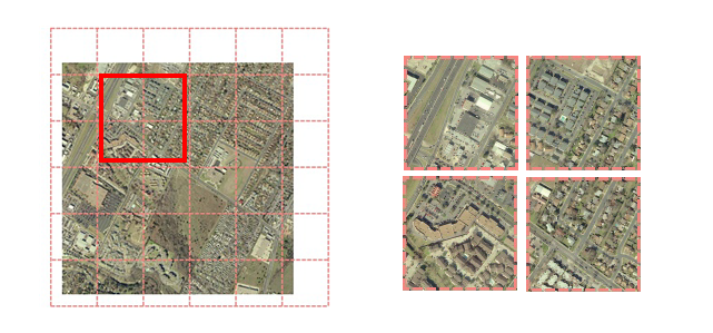
Splits each input raster into a series of tiles by specifying either a tile size or a number of tiles.
Note: Note: Alternatively, you can use the Tiler transformer. The following table compares the Tiler and the RasterTiler:
| Tiler | RasterTiler | |
|---|---|---|
| Type of data accepted | All types | Raster only |
| Tile size units | Ground coordinates | Pixel coordinates |
| Tile row numbering (0, 1,...) | Bottom to top | Top to bottom |
| Supports forcing equal-size tiles | No | Yes |
| Supports raster index attribute | No | Yes |
| Supports number of horizontal/vertical tiles attribute | No | Yes |
Parameters
Choose how the input raster should be split.
These parameters specify the size of the subset in cells to be taken from the raster. They do not include any padding values. These values must be greater than 0 for the input to be valid.
These parameters specify a "seed" location from which tiling will start. That is, tile boundaries will align with the specified location. By default this is (0,0), meaning tiling starts from the upper-left corner of the raster.
These parameters specify the number of tiles into which the input rasters will be split. These values must be greater than 0.
This parameter controls behavior when the raster size is not a multiple of the requested tile size or number of tiles.
No: Tiles on the right or bottom edge of the raster may be smaller than other tiles.
Yes: All tiles will be the same size.
Tiles that go off the edge of the raster will be padded with the nodata value if one is set on the band; if no nodata value is set, RGB rasters will have an alpha band added to identify the padding regions.
For example, suppose you have a raster of size 1000 columns and a selected column tile size of 256. When this option is No, three tiles of 256 columns and one tile of 232 columns will be generated. When this option is Yes, four tiles of 256 columns will be generated, where the last tile contains 24 columns of padding.
An attribute will be added to each output tile that identifies which raster it was created from. This index is zero-based, so all tiles created from the first input raster will have a value of 0, all tiles created from the second input raster will have a value of 1, and so on.
Attributes will be added to each output tile that identify the position of that tile in the input raster. These indices are zero-based.
Tile row 0, tile column 0 corresponds to the upper-left tile.
Attributes will be added to each output tile that identify the number of horizontal and vertical tiles in the input raster.
Usage Notes
This transformer is unaffected by raster band and palette selection.
Example

Editing Transformer Parameters
Using a set of menu options, transformer parameters can be assigned by referencing other elements in the workspace. More advanced functions, such as an advanced editor and an arithmetic editor, are also available in some transformers. To access a menu of these options, click  beside the applicable parameter. For more information, see Transformer Parameter Menu Options.
Transformer Categories
FME Licensing Level
FME Professional edition and above
Search FME Knowledge Center
Search for samples and information about this transformer on the FME Knowledge Center.
Tags Keywords: raster grid band clip tile subset