RasterStatisticsCalculator
Calculates statistics on raster bands and adds the results as attributes.
Jump to Configuration
Typical Uses
How does it work?
The RasterStatisticsCalculator receives raster features and calculates selected statistics on them individually. The results are output on each raster, and may be generated for Band, Palette, or both.
Available statistics include:
- Minimum
- Maximum
- Mean
- Sum
- Range
- Standard Deviation
- Median
- Mode
Band statistics are stored as attributes, named <band>.<statisticname>.
Palette statistics are calculated on resolved palette values, and are stored as list attributes, named <band>.<palette>.<statisticname>.
For both types of attribute, <statisticname> will be one of the following: min, max, range, mean, stdev, sum, median, mode.
For multi-band rasters, any additional bands beyond Band 0 must be explicitly specified for inclusion in the parameters dialog - Statistics to Calculate table, under Band Index.
To calculate raster statistics on a group of rasters as a single entity, merge them prior to this transformer with the RasterBandCombiner or RasterMosaicker.
 Example: Calculating statistics on a DEM
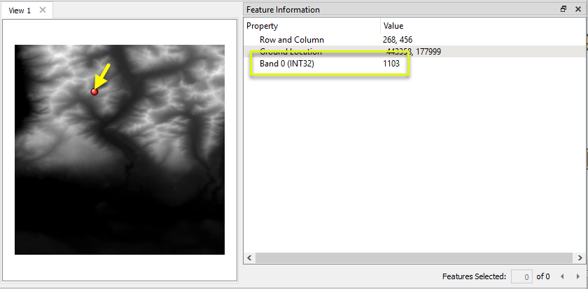
In this example, we will generate some statistics on an elevation raster. The source data has elevation values (in meters) stored in Band 0.

The DEM is routed into a RasterStatisticsCalculator.

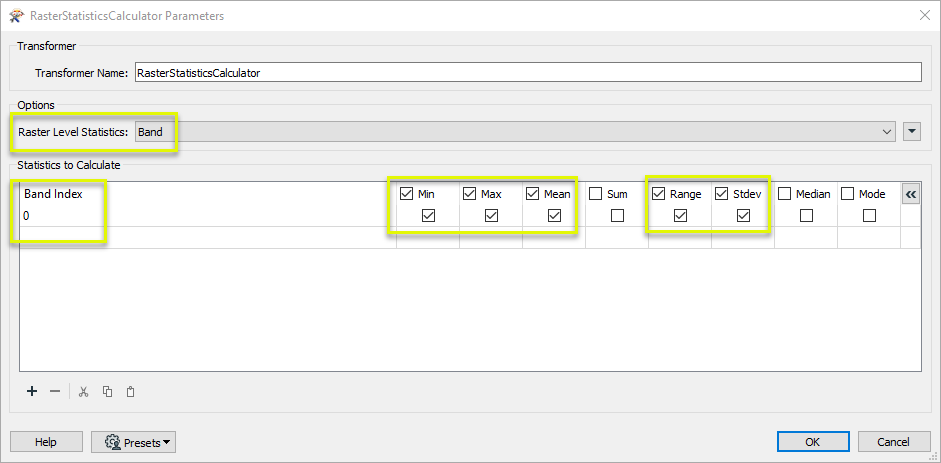
In the parameters dialog, Raster Level Statistics is set to Band. By default, Band Index 0 is included in the Statistics to Calculate table, and we choose our desired statistics.

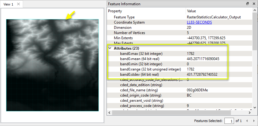
The output feature has new attributes containing the requested statistics. Note that the entire raster is selected here, not an individual cell.

Choosing a Raster Transformer
FME has an extensive selection of transformers for working with raster data. They can be generally categorized as working with whole rasters, bands, cells or palettes, and those designed for workflow control or combing raster with vector data.
For information on raster geometry and properties, see Rasters (IFMERaster).
 Raster Transformers
Working with Rasters
 These transformers generally apply to whole rasters.
| RasterCellOriginSetter
|
Sets the cell origin point within cells in a raster.
|
| RasterConvolver
|
Applies a convolution filter (sometimes called a kernel or lens) to raster features and outputs the results.
|
| RasterExpressionEvaluator
|
Evaluates expressions on each cell in a raster or pair of rasters, including algebraic operations and conditional statements.
|
| RasterExtentsCoercer
|
Replaces the geometry of input raster features with a polygon covering either the extents of a raster or the extent of data within a raster.
|
| RasterGCPExtractor
|
Extracts Ground Control Point (GCP) coordinate system and point values from a raster feature and exposes them as attributes.
|
| RasterGCPSetter
|
Sets Ground Control Points (GCPs) on a raster, pairing cell positions with known coordinates.
|
| RasterGeoreferencer
|
Georeferences a raster by either known corner coordinates or origin, cell size, and rotation.
|
| RasterHillshader
|
Generates a grayscale shaded relief representation of terrain, based on elevation values.
|
| RasterInterpretationCoercer
|
Alters the interpretation type of rasters, including all bands, and converts cell values if necessary.
|
| RasterMosaicker
|
Merges multiple raster features into a single raster feature.
|
| RasterPropertyExtractor
|
Extracts the geometry properties of a raster feature and exposes them as attributes.
|
| RasterPyramider
|
Resamples rasters to multiple resolutions, based on either number of levels or dimensions of the smallest output raster. |
| RasterResampler
|
Resamples rasters, based on specified output dimensions, cell size in ground units, or percentage of original, and interpolates new cell values.
|
| RasterRotationApplier
|
Rotates a raster feature according to its rotation angle property, interpolating new cell values, updating all other affected raster properties, and producing an output raster feature with a rotation angle of zero.
|
| RasterSubsetter
|
Clips raster features using pixel bounds instead of ground coordinates, and optionally adds cells around the perimeter.
|
| RasterTiler
|
Splits each input raster into a series of tiles by specifying either a tile size in cells/pixels or the number of tiles.
|
| RasterToPolygonCoercer
|
Creates polygons from input raster features. One polygon is output for each contiguous area of pixels with the same value in the input raster.
|
| WebMapTiler
|
Creates a series of image tiles that can be utilized by web mapping applications such as Bing™ Maps, Google Maps™, or Web Map Tile Service. This is done by resampling rasters to various different resolutions and then splitting them into tiles.
|
Working with Bands
Working with Cells
Working with Palettes
Workflow Control
 These transformers generally control the flow of features in a workspace.
| RasterCheckpointer
|
Forces accumulated raster operations to be processed, saving the state to disk and releasing resources to tune performance or assist with memory limitations. |
| RasterConsumer
|
Reads raster features for testing purposes, including any accumulated raster operations. No additional operations are performed, and nothing is done with the features. |
| RasterExtractor
|
Serializes the geometry of a raster feature into a Blob attribute, encoding the contents according to a choice of common binary raster formats.
|
| RasterNumericCreator
|
Creates a numeric raster of specified size and resolution, with default cell values.
|
| RasterReplacer
|
Decodes a binary attribute containing encoded rasters stored as Blobs, replacing the feature’s geometry with the decoded raster.
|
| RasterRGBCreator
|
Creates a color raster feature of specified size, resolution, and interpretation type, with default cell values.
|
| RasterSelector
|
Selects specific bands and palettes of a raster for subsequent transformer operations.
|
Vectors and Rasters
 These transformers generally involve using rasters and vector data together.
| ImageRasterizer
|
Creates a raster representation of vector or point cloud input features, using the fme_color attribute over a solid background fill for vector features. Point clouds may be rendered using their color or intensity components.
|
| NumericRasterizer
|
Creates a numeric raster representation of vector or point cloud input features, where cell values are taken from the z coordinates of the input features and overlaid on a uniform background.
|
| MapnikRasterizer
|
Generates a raster from input vector and raster features, with fine control over symbolization and labeling, using the Mapnik toolkit.
|
| PointOnRasterValueExtractor
|
Extracts the band and palette values from a raster at the location of one or more input points and sets them as attributes on the feature. |
| RasterDEMGenerator
|
Produces a raster digital elevation model (DEM) by uniformly sampling a Delaunay triangulation generated from input points and breaklines. |
| VectorOnRasterOverlayer
|
Rasterizes vector or point cloud features onto an existing raster. For vector features the fme_color attribute sets pixel color, and point clouds may be rendered using their color or intensity components.
|
Configuration
Input Ports
 Input
Input
This transformer accepts only raster features. Palettes are supported.
Output Ports
 Output
Raster features with the specified calculated statistics.
Band statistics are stored as standard attributes, and Palette statistics are stored as list attributes.
 <Rejected>
Non-raster features will be routed to the <Rejected> port, as well as invalid rasters.
Rejected features will have an fme_rejection_code attribute with one of the following values:
INVALID_GEOMETRY_TYPE
INVALID_RASTER_NO_BANDS
INVALID_RASTER_CANNOT_CREATE_POINT_CLOUD
Rejected Feature Handling: can be set to either terminate the translation or continue running when it encounters a rejected feature. This setting is available both as a default FME option and as a workspace parameter.
Parameters
 Options
| Raster Level Statistics
|
Specifies for all bands chosen: whether to calculate statistics on band values, resolved palette values, or both.
If Band is selected and a band with palette(s) is encountered, statistics will be calculated on the band’s cell values.
If Palette is selected and a band with no palette is encountered, no statistics will be calculated for that band.
If Band and Palette is selected, statistics will be calculated for bands without palettes, bands with palettes will calculate resolved palette values and cell values.
|
 Statistics to Calculate
Specifies which statistics to calculate for each band.
| Band Index
|
Bands are specified by their index number, starting at 0.
Band 0 is included by default, and any additional bands must be explicitly specified for inclusion.
|
| Statistics
|
The following statistics may be calculated:
| Minimum |
The numerical minimum for numeric values, or the lexical minimum for string values. |
| Maximum
|
The numerical maximum for numeric values, or the lexical maximum for string values. |
| Mean
|
The average value, calculated as the sum of values divided by the number of cells. Undefined for string values. |
| Sum
|
The sum of all values. Undefined for string values. |
| Range
|
The maximum minus the minimum. Undefined for string values. |
| Standard Deviation
|
The standard deviation as measured by the "nonbiased" or "n-1" method. Undefined for string values. |
|
Median
|
The middle value when the values are listed in order if the number of cells is odd, or the average of the two middle values if the number of cells is even. For string values, the first middle value is always used. |
| Mode
|
The most frequent of all the values. If the dataset is bimodal (two or more values occur with the highest frequency) one of the values will be returned randomly. |
|
Editing Transformer Parameters
Using a set of menu options, transformer parameters can be assigned by referencing other elements in the workspace. More advanced functions, such as an advanced editor and an arithmetic editor, are also available in some transformers. To access a menu of these options, click  beside the applicable parameter. For more information, see Transformer Parameter Menu Options.
Defining Values
There are several ways to define a value for use in a Transformer. The simplest is to simply type in a value or string, which can include functions of various types such as attribute references, math and string functions, and workspace parameters. There are a number of tools and shortcuts that can assist in constructing values, generally available from the drop-down context menu adjacent to the value field.
 How to Set Parameter Values
Using the Text Editor
The Text Editor provides a convenient way to construct text strings (including regular expressions) from various data sources, such as attributes, parameters, and constants, where the result is used directly inside a parameter.
Text Editor
Using the Arithmetic Editor
The Arithmetic Editor provides a convenient way to construct math expressions from various data sources, such as attributes, parameters, and feature functions, where the result is used directly inside a parameter.
Arithmetic Editor
Conditional Values
Set values depending on one or more test conditions that either pass or fail.
Parameter Condition Definition Dialog
Content
Expressions and strings can include a number of functions, characters, parameters, and more - whether entered directly in a parameter or constructed using one of the editors.
Reference
FME Community
The FME Community is the place for demos, how-tos, articles, FAQs, and more. Get answers to your questions, learn from other users, and suggest, vote, and comment on new features.
Search for all results about the RasterStatisticsCalculator on the FME Community.
Examples may contain information licensed under the Open Government Licence – Vancouver


 beside the applicable parameter. For more information, see