FME Transformers: 2026.2
Related Transformers
3DForcer
DEMGenerator
NumericRasterizer
SurfaceModeller
Produces a raster digital elevation model (DEM) by uniformly sampling a Delaunay triangulation generated from input points and breaklines.
Typical Uses
- Creating raster elevation models from non-gridded features such as contours or point clouds.
How does it work?
The RasterDEMGenerator receives input features, triangulates a surface based on them, and then outputs a raster DEM with elevation values sampled from the surface at a specified regular interval. The output raster will contain a single numeric band, of the interpretation type Real64.
The input features are discarded.
Input features can be of a variety of types, including points, lines, areas, rasters, and point clouds. Aggregate geometries are supported, and multiple input features and types may be combined to produce one raster DEM output feature.
There are two input ports - Points/Lines and Breaklines. At least one input feature must be provided, which may be routed into either of these ports.
Input features may be either 2D or 3D - however, 2D features will be forced to 3D with an elevation (z value) of zero (0). If the source dataset’s z values are not stored as z coordinates (for example, contours with elevation stored as an attribute), a 3DForcer transformer may be used to convert them to a z coordinate prior to entering the RasterDEMGenerator.
A choice of breakline handling and interpolation methods is available. Surface tolerance and cell spacing may be adjusted, and a Nodata value may be defined.
This transformer is unaffected by raster band and palette selection.
Examples
In this example, we will generate a DEM from a set of contour lines, spaced at a ten meter interval. Note that the source data does not have elevation values as a z coordinate - though it is a 3D dataset, the z values are all zero (0).
The elevation values are stored as an attribute named ELEVATION and need to be applied as z values before the DEM is generated.
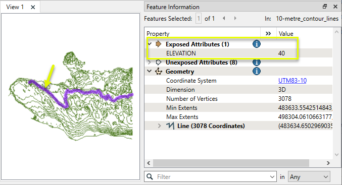
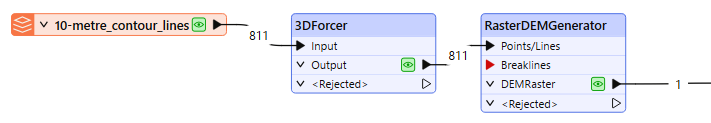
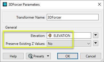
The contours are routed first into a 3DForcer, and then to the RasterDEMGenerator.
In the 3DForcer parameters dialog, Elevation is set to the ELEVATION attribute, and Preserve Existing Z Values is set to No. The attribute values will overwrite the existing z values.
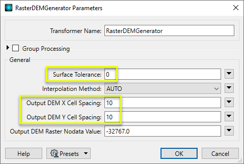
Next, in the RasterDEMGenerator’s parameters dialog, we set Surface Tolerance to zero (0), which means that no vertex filtering will take place, and all points will be considered.
Cell Spacing (both X and Y) is set to 10. The output cells will be 10 meters square, as the source data’s coordinate system is in meters.
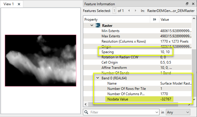
The output DEM raster has a single Real64 band, 10 meter square cells, and the specified Nodata value.
Usage Notes
- If input features’ elevation values are not stored as Z coordinates, use a 3DForcer prior to the RasterDEMGenerator.
- To produce individual elevation points instead of a raster, consider using the DEMGenerator.
-
To build a TIN (triangulated irregular network) surface from points, lines, and/or rasters, see the TINGenerator and SurfaceModeller.
- When processing large input datasets, increasing the Surface Tolerance may provide performance gains, but may reduce accuracy.
- For more complex elevation modelling tasks, such as including contour generation, accessing components of the underlying surface model, feature draping, or creating multiple representations of a surface model, consider using the SurfaceModeller.
Choosing a Raster Transformer
FME has an extensive selection of transformers for working with raster data. They can be generally categorized as working with whole rasters, bands, cells or palettes, and those designed for workflow control or combining raster with vector data.
For information on raster geometry and properties, see Rasters (IFMERaster).
Working with Rasters
|
Sets the cell origin point within cells in a raster. |
|
|
Applies a convolution filter (sometimes called a kernel or lens) to raster features and outputs the results. |
|
|
Enhances the features of a raster image. The RasterDiffuser enhances the borders, lines, and curves while reducing noise in the flat areas of the raster image. |
|
|
Evaluates expressions on each cell in a raster or pair of rasters, including algebraic operations and conditional statements. |
|
|
Replaces the geometry of input raster features with a polygon covering either the extents of a raster or the extent of data within a raster. |
|
|
Extracts Ground Control Point (GCP) coordinate system and point values from a raster feature and exposes them as attributes. |
|
|
Sets Ground Control Points (GCPs) on a raster, pairing cell positions with known coordinates. |
|
|
Georeferences a raster by either known corner coordinates or origin, cell size, and rotation. |
|
|
Generates a grayscale shaded relief representation of terrain, based on elevation values. |
|
|
Alters the interpretation type of rasters, including all bands, and converts cell values if necessary. |
|
|
Merges multiple raster features into a single raster feature. |
|
|
Extracts the geometry properties of a raster feature and exposes them as attributes. |
|
|
Resamples rasters to multiple resolutions, based on either number of levels or dimensions of the smallest output raster. |
|
|
Transforms an image to minimize its difference with another. |
|
|
Resamples rasters, based on specified output dimensions, cell size in ground units, or percentage of original, and interpolates new cell values. |
|
|
Rotates a raster feature according to its rotation angle property, interpolating new cell values, updating all other affected raster properties, and producing an output raster feature with a rotation angle of zero. |
|
|
Clips raster features using pixel bounds instead of ground coordinates, and optionally adds cells around the perimeter. |
|
|
Splits each input raster into a series of tiles by specifying either a tile size in cells/pixels or the number of tiles. |
|
|
Creates polygons from input raster features. One polygon is output for each contiguous area of pixels with the same value in the input raster. |
|
|
Creates a series of image tiles that can be utilized by web mapping applications such as Bing™ Maps, Google Maps™, or Web Map Tile Service. This is done by resampling rasters to various different resolutions and then splitting them into tiles. |
Working with Bands
|
Adds a new band to a raster feature. |
|
|
Merges coincidental raster features into a single output raster feature, preserving and appending all bands. |
|
|
Alters the interpretation type of individual raster bands, converting cell values if necessary. |
|
|
Removes all unselected bands from a raster feature. |
|
|
Extracts the minimum and maximum band values, palette keys, and palette values from a raster feature, and adds them to a list attribute. |
|
|
Sets the band name of selected bands on a raster, making raster contents simpler to understand compared to band numbers. |
|
|
Removes the existing Nodata identifier from selected bands of a raster feature. Any values previously equal to the Nodata value are considered valid data. |
|
|
Sets a new Nodata value on selected bands of a raster feature. |
|
|
Specifies the required order of bands in a raster. Bands are reordered according to the input band indices. |
|
|
Extracts the band and palette properties of a raster feature and exposes them as attributes. |
|
|
Removes any selected bands from a raster feature. |
|
|
Separates bands or unique band and palette combinations, and outputs either individual raster features or a single new raster feature containing all combinations. |
|
|
Calculates statistics on raster bands and adds the results as attributes. |
Working with Cells
|
Calculates the aspect (direction of slope) for each cell of a raster. Aspect is measured in degrees from 0 to 360, clockwise from north. |
|
|
Creates individual points or polygons for each cell in a raster, optionally extracting band values as z coordinates or attributes. |
|
|
Evaluates basic arithmetic , minimum, maximum or average operations on the cell values of a pair of rasters. |
|
|
Replaces a range of band values in a raster with a new single value. |
|
|
Rounds off raster cell values. |
|
|
Partitions a raster image into arbitrarily sized groups of cells from the input image based on intensity differences in the input raster image cells. |
|
|
Performs basic arithmetic operations on the cell values of a raster against a numeric value. |
|
|
Calculates the slope (maximum rate of change in z) for each cell of a raster. |
Working with Palettes
|
Creates a palette from an attribute, and adds this palette to all selected bands on a raster. |
|
|
Creates a string representation of an existing palette on a raster and saves it to an attribute. |
|
|
Generates a palette out of the selected band(s) of a raster. The output raster will have the selected band(s) replaced by a new band with a palette. |
|
|
Alters the interpretation type of raster palettes. |
|
|
Identifies the palette key that matches a raster band’s Nodata value, and sets a value on it. |
|
|
Removes selected palette(s) from raster features. |
|
|
Resolves the palette(s) on a raster by replacing cell values with their corresponding palette values. Palette values with multiple components, such as RGB, are broken down and the individual values assigned to multiple, newly-added bands. |
Workflow Control
|
Forces accumulated raster operations to be processed, saving the state to disk and releasing resources to tune performance or assist with memory limitations. |
|
|
Reads raster features for testing purposes, including any accumulated raster operations. No additional operations are performed, and nothing is done with the features. |
|
|
Serializes the geometry of a raster feature into a Blob attribute, encoding the contents according to a choice of common binary raster formats. |
|
|
Creates a numeric raster of specified size and resolution, with default cell values. |
|
|
Decodes a binary attribute containing encoded rasters stored as Blobs, replacing the feature’s geometry with the decoded raster. |
|
|
Creates a color raster feature of specified size, resolution, and interpretation type, with default cell values. |
|
|
Selects specific bands and palettes of a raster for subsequent transformer operations. |
Vectors and Rasters
|
Creates a raster representation of vector or point cloud input features, using the fme_color attribute over a solid background fill for vector features. Point clouds may be rendered using their color or intensity components. |
|
|
Creates a numeric raster representation of vector or point cloud input features, where cell values are taken from the z coordinates of the input features and overlaid on a uniform background. |
|
|
Generates a raster from input vector and raster features, with fine control over symbolization and labeling, using the Mapnik toolkit. |
|
|
Sets point cloud component values by overlaying a point cloud on a raster. The component values for each point are interpolated from band values at the point location. |
|
|
Extracts the band and palette values from a raster at the location of one or more input points and sets them as attributes on the feature. |
|
|
Produces a raster digital elevation model (DEM) by uniformly sampling a Delaunay triangulation generated from input points and breaklines. |
|
|
Rasterizes vector or point cloud features onto an existing raster. For vector features the fme_color attribute sets pixel color, and point clouds may be rendered using their color or intensity components. |
Configuration
Input Ports
These input features may be 2D or 3D. Other than points, lines and area geometries, they may also be raster, point cloud, and aggregate geometries.
2D features will be forced to 3D by adding a z value of 0. In most cases, all points extracted from this port will be found in the vertex pool of the underlying surface model. A minimum of 3 unique points are required to construct a surface model. Points with duplicate x and y values will be dropped.
These input features may be 2D or 3D, and may reside inside an aggregate structure.
2D features will be forced to 3D by adding a z value of 0. Breakline edges will be found in the edge pool of the underlying surface model. Sometimes, a breakline edge will be split up to allow an optimal triangulation of the surface model. Points with duplicate x and y values will be dropped.
Output Ports
This output port samples the underlying surface model according to the sampling rates specified in Output DEM X Cell Spacing, and Output DEM Y Cell Spacing, and produces a single raster feature consisting of evenly spaced 3D points arranged by rows and columns.
Features without valid geometry are output via this port. In many cases, only the invalid parts of a larger feature will be rejected while the remaining valid parts are processed.
Rejected features will have an fme_rejection_code attribute with one of the following values:
INVALID_GEOMETRY_DIMENSION
INVALID_GEOMETRY_TYPE
INVALID_GEOMETRY_VERTICES
INVALID_BREAKLINES_GEOMETRY_VERTICES
INVALID_POINT_GEOMETRY_VERTICES
INVALID_POINTS_GEOMETRY_RASTER_NUM_BANDS
INVALID_POINTS_GEOMETRY_RASTER_NUM_PALETTES
INCONSISTENT_PER_GROUP_VALUE
INVALID_PARAMETER_TOLERANCE
INVALID_PARAMETER_X_CELL_SPACING
INVALID_PARAMETER_Y_CELL_SPACING
Rejected Feature Handling: can be set to either terminate the translation or continue running when it encounters a rejected feature. This setting is available both as a default FME option and as a workspace parameter.
Parameters
|
Group By |
This parameter allows groups to be formed by attribute values. Zero or more attributes may be specified. Input features with the same attribute values are placed into the same group. The transformer then operates independently on each group of input features. If this parameter is left blank, the transformer will treat the entire set of input features as one group. |
||||
|
Complete Groups |
Select the point in processing at which groups are processed:
There are two typical reasons for using When Group Changes (Advanced) . The first is incoming data that is intended to be processed in groups (and is already so ordered). In this case, the structure dictates Group By usage - not performance considerations. The second possible reason is potential performance gains. Performance gains are most likely when the data is already sorted (or read using a SQL ORDER BY statement) since less work is required of FME. If the data needs ordering, it can be sorted in the workspace (though the added processing overhead may negate any gains). Sorting becomes more difficult according to the number of data streams. Multiple streams of data could be almost impossible to sort into the correct order, since all features matching a Group By value need to arrive before any features (of any feature type or dataset) belonging to the next group. In this case, using Group By with When All Features Received may be the equivalent and simpler approach. Note Multiple feature types and features from multiple datasets will not generally naturally occur in the correct order.
As with many scenarios, testing different approaches in your workspace with your data is the only definitive way to identify performance gains. |
|
Surface Tolerance |
This parameter is used to determine which input points to add to the surface model as vertices. Specifying a value of 0 turns off vertex filtering. Tip: A larger value will speed up surface model construction. The larger the value, the more input points will be filtered out. For input files with millions – or even billions – of points, it becomes essential to increase this value. When a positive value for surface tolerance is specified, it works as follows. For each vertex that is being added to the model:
|
||||||
|
Breakline Method |
Select the way in which breaklines will affect the triangulation if their edges would violate the Delaunay condition, which helps to prevent narrow triangles.
|
||||||
|
Breakline Tolerance |
When Breakline Method is Preserve Delaunay by Adding Points , select or specify a tolerance value, which is the maximum distance that subdivided edges may deviate from the input breakline edge. Smaller values will make the representation of breaklines more accurate, but may require the addition of many points in cases where breakline edges are nearby one another. Automatic calculates an appropriate tolerance for the input geometry, and is generally recommended. A Custom Value may be entered, but must be greater than zero and greater than the Automatic value. |
||||||
|
Interpolation Method |
This parameter is used for the output ports DEMPoints and DEMRaster when these output ports exist on the transformer. It is also used if DrapeFeatures are input to the model. Select a method:
|
||||||
|
Output DEM X Cell Spacing
|
These parameters specify the x and y sampling intervals for the output DEMPoints. |
||||||
|
Output DEM Raster Nodata Value |
This parameter is used only when Interpolation Method is set to Linear, and it only affects the output port DEMRaster. All output raster cells that fall outside the underlying surface model’s boundaries will be assigned the value of this parameter. When this parameter is blank, it is interpreted as NaN (Not a Number). Note: To ensure consistent raster output, it is highly recommended that you do not leave this parameter blank. |
Editing Transformer Parameters
Transformer parameters can be set by directly entering values, using expressions, or referencing other elements in the workspace such as attribute values or user parameters. Various editors and context menus are available to assist. To see what is available, click  beside the applicable parameter.
Defining Values
There are several ways to define a value for use in a Transformer. The simplest is to simply type in a value or string, which can include functions of various types such as attribute references, math and string functions, and workspace parameters.
Using the Text Editor
The Text Editor provides a convenient way to construct text strings (including regular expressions) from various data sources, such as attributes, parameters, and constants, where the result is used directly inside a parameter.
Using the Arithmetic Editor
The Arithmetic Editor provides a convenient way to construct math expressions from various data sources, such as attributes, parameters, and feature functions, where the result is used directly inside a parameter.
Conditional Values
Set values depending on one or more test conditions that either pass or fail.
Parameter Condition Definition Dialog
Content
Expressions and strings can include a number of functions, characters, parameters, and more.
When setting values - whether entered directly in a parameter or constructed using one of the editors - strings and expressions containing String, Math, Date/Time or FME Feature Functions will have those functions evaluated. Therefore, the names of these functions (in the form @<function_name>) should not be used as literal string values.
| These functions manipulate and format strings. | |
|
Special Characters |
A set of control characters is available in the Text Editor. |
| Math functions are available in both editors. | |
| Date/Time Functions | Date and time functions are available in the Text Editor. |
| These operators are available in the Arithmetic Editor. | |
| These return primarily feature-specific values. | |
| FME and workspace-specific parameters may be used. | |
| Creating and Modifying User Parameters | Create your own editable parameters. |
Table Tools
Transformers with table-style parameters have additional tools for populating and manipulating values.
|
Row Reordering
|
Enabled once you have clicked on a row item. Choices include:
|
|
Cut, Copy, and Paste
|
Enabled once you have clicked on a row item. Choices include:
Cut, copy, and paste may be used within a transformer, or between transformers. |
|
Filter
|
Start typing a string, and the matrix will only display rows matching those characters. Searches all columns. This only affects the display of attributes within the transformer - it does not alter which attributes are output. |
|
Import
|
Import populates the table with a set of new attributes read from a dataset. Specific application varies between transformers. |
|
Reset/Refresh
|
Generally resets the table to its initial state, and may provide additional options to remove invalid entries. Behavior varies between transformers. |


Note: Not all tools are available in all transformers.
For more information, see Transformer Parameter Menu Options.
Reference
|
Processing Behavior |
|
|
Feature Holding |
Yes |
| Dependencies | None |
| Aliases | DEMRasterGenerator DEMGridGenerator |
| History |
FME Online Resources
The FME Community and Support Center Knowledge Base have a wealth of information, including active forums with 35,000+ members and thousands of articles.
Search for all results about the RasterDEMGenerator on the FME Community.
Examples may contain information licensed under the Open Government Licence – Vancouver, Open Government Licence - British Columbia, and/or Open Government Licence – Canada.