Viewing Start and End Coordinates
You can mark the starting and ending coordinates of features that appear in the View window in 2D mode. You can view starting and ending coordinates of line, arc, path, polygon, and donut geometries.
Note: To view all coordinates of a geometry, and not just the starting and ending coordinates, see Viewing Coordinates and Text Insertion Points.
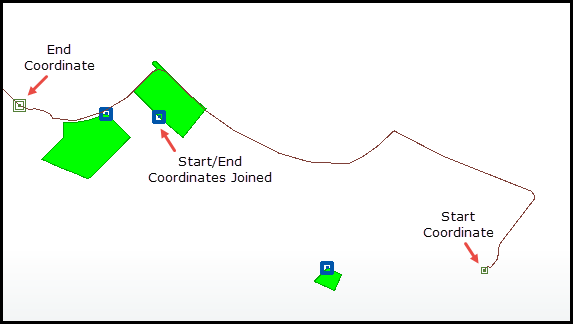
There are three types of markers:
- Square with center point: The starting coordinate of a geometry.
- Two squares with center point: The ending coordinate of a geometry.
- Thick square with center point: The starting and ending coordinates of a geometry that are joined together (that is, they are the same value).
In this example, the starting and ending coordinates that comprise parks and a bicycle path are marked:
Note: Viewing starting and ending coordinates is not supported when viewing data in 3D mode.
To view starting and ending coordinates, right-click on the view, dataset, or feature type in the Display Control, and select Mark End Nodes. To mark all start and end coordinates that display in the View, right-click on the view. To mark start and end coordinates of all features in a dataset, right-click on the dataset. To mark start and end coordinates of all features of a feature-type, right-click only on the feature type.
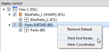
To remove all start and end coordinates, right-click at the level you want to remove, and unselect Mark End Nodes. If a view contains more than one dataset, or a dataset contains more than one feature type, you can specify Mark End Nodes > All or Mark End Nodes > None at the view or dataset level. At the view level, these options allow you to toggle from displaying start and end coordinates of a subset of datasets to displaying start and end coordinates of either all datasets, or no start/end coordinate at all. Similarly, at the dataset level, these options allow you to toggle from displaying start and end coordinates of a subset of feature types to displaying start and end coordinates of either all feature types, or none of the feature types.