FME Transformers: 2026.1
Categories
Data Quality
Database
Filters and Joins
Spatial Analysis
Related Transformers
AreaOnAreaOverlayer
Bufferer
Clipper
Intersector
LineOnAreaOverlayer
LineOnLineOverlayer
NeighborFinder
PointOnAreaOverlayer
PointOnLineOverlayer
PointOnPointOverlayer
SpatialRelator
TopologyBuilder
Filters point, line, area, and text features based on spatial relationships.
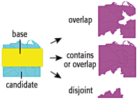
Each input Candidate feature is compared against all Filter features, based on the given spatial tests to meet. Features that pass any or all tests are output through the Passed port; all other features are output through the Failed port.
Typical Uses
- Routing features, depending on whether a defined spatial relationship is true or false
- Performing quality control on a dataset by checking for expected spatial relationships with another dataset
- Performing a spatial join to transfer attributes from one feature to another based on their spatial relationship
How does it work?
The SpatialFilter compares two sets of features to see if their spatial relationships meet selected test conditions. The features being tested (Candidate features) are identified as having Passed or Failed the test.
For example, if you have a roads dataset (lines), and wanted to extract all the roads that passed through parks (polygons), you would direct the roads into the Candidate input port, and the parks into the Filter input port.
By selecting the test conditions Filter OGC-Intersects Candidate and Filter OGC-Contains Candidate, any road lines that fall within the parks or intersect the parks would be output via the Passed output port, and the remainder would exit through the Failed output port. You could simultaneously extract an attribute from the park polygon – park name, for example – and add it to the line feature.
Examples
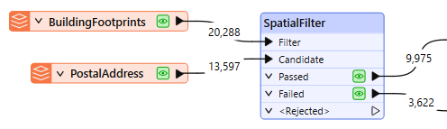
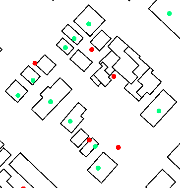
In this example, we identify address points that are not contained by a building footprint. The results could be used to find bad address points, or identify missing building polygons.
The two source datasets look like this:
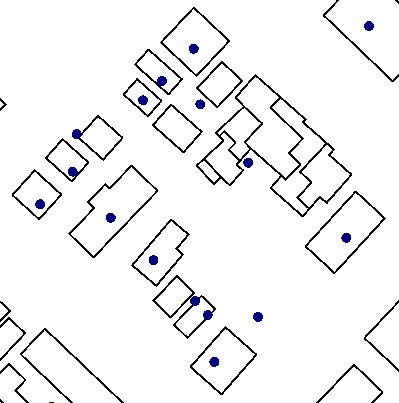
The address points – the dataset to be tested – are connected to the Candidate input port. The building footprints are connected to the Filter port, and provide the geometry that the address points will be tested against.
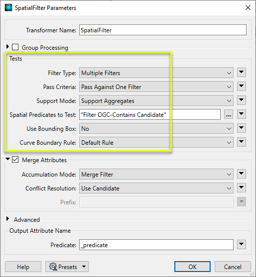
In the SpatialFilter parameters dialog, we make the following selections:
- Filter Type: Multiple Filters. There are multiple building polygons that we want to test against.
- Pass Criteria: Pass Against One Filter. Each address point only needs to fall inside one polygon – not all of them.
- Spatial Predicates to Test: Filter OGC-Contains Candidate. We want to check if each Candidate (address point) falls within a filter (building polygon).
These are the key parameters – the others are left as default for this example.
Address points that pass the test – that are within a polygon – are sent out through the Passed port, and have a new attribute called _predicate, set to “CONTAINS”.
Address points that fail the test – that are outside all polygons – are sent out through the Failed port. The results, with styling applied in the FME Data Inspector, look like this:
Usage Notes
- See Spatial Relations Defined for more information on spatial predicates and an illustration of spatial relationships.
- Spatial relations are based on the OGC specification and so are undefined for geometries that are not OGC valid.
- Aggregates are accepted by a subset of predicates, but should be used with care. See Spatial Relations Defined for more information.
Choosing a Spatial Transformer
Many transformers can assess spatial relationships and perform spatial joins - analyzing topology, merging attributes, and sometimes modifying geometry. Generally, choosing the one that is most specific to the task you need to accomplish will provide the optimal performance results. If there is more than one way to do it (which is frequently the case), time spent on performance testing alternate methods may be worthwhile.
To correctly analyze spatial relationships, all features should be in the same coordinate system. The Reprojector may be useful for reprojecting features within the workspace.
|
Transformer |
Can Merge Attributes |
Alters Geometry |
Counts Related Features |
Creates List |
Supported Types* |
Recommended For |
|---|---|---|---|---|---|---|
| SpatialFilter | Yes | No | No | No |
|
|
| SpatialRelator | Yes | No | Yes | Yes |
|
|
| AreaOnAreaOverlayer | Yes | Yes | Yes | Yes |
|
|
| LineOnAreaOverlayer | Yes | Yes | Yes | Yes |
|
|
| LineOnLineOverlayer | Yes | Yes | Yes | Yes |
|
|
| PointOnAreaOverlayer | Yes | No | Yes | Yes |
|
|
| PointOnLineOverlayer | Yes | Yes | Yes | Yes |
|
|
| PointOnPointOverlayer | Yes | No | Yes | Yes |
|
|
| Intersector | Yes | Yes | Yes | Yes |
|
|
| Clipper | Yes | Yes | No | No |
|
|
| NeighborFinder | Yes | In some cases | No | Yes |
|
|
| TopologyBuilder | Yes | Yes | No | Yes |
|
|
* Note that Curve includes Lines, Arcs, and Paths. Area includes Polygons, Donuts, and Ellipses.
Spatial analysis can be processing-intensive, particularly when a large number of features are involved. If you would like to tune the performance of your workspace, this is a good place to start.
When there are multiple ways to configure a workspace to reach the same goal, it is often best to choose the transformer most specifically suited to your task.
If performance is an issue in your workspace, look for alternative methods, guided by geometry.
Configuration
Input Ports
Point, line, area, and text features against which Candidates will be compared. These features are not output.
Point, line, area, and text features that will be tested against the Filter features.
Output Ports
Candidate features that successfully meet the test conditions selected in the parameters dialog.
Candidate features that do not meet the test conditions.
Filter and Candidate features with invalid geometries will be rejected and output via this port. If predicates are provided via an attribute, Candidate features with no or invalid predicates will also be output via this port.
Rejected features will have an fme_rejection_code attribute with one of the following values:
EXTRA_BASE_FEATURE
INVALID_BASE_GEOMETRY_NOT_OGC_VALID
INVALID_BASE_GEOMETRY_TYPE
INVALID_CANDIDATE_GEOMETRY_NOT_OGC_VALID
INVALID_CANDIDATE_GEOMETRY_TYPE
INVALID_CANDIDATE_PARAMETER_PREDICATE
INVALID_GEOMETRY_TYPE
MISSING_CANDIDATE_PARAMETER_PREDICATE
Rejected Feature Handling: can be set to either terminate the translation or continue running when it encounters a rejected feature. This setting is available both as a default FME option and as a workspace parameter.
Parameters
|
Group By |
If Group By attributes are specified, candidates are only compared against filters with the same values in these attributes. Both the Candidates and Filters must having matching attribute names and values. |
||||
|
Complete Groups |
Select the point in processing at which groups are processed:
There are two typical reasons for using When Group Changes (Advanced) . The first is incoming data that is intended to be processed in groups (and is already so ordered). In this case, the structure dictates Group By usage - not performance considerations. The second possible reason is potential performance gains. Performance gains are most likely when the data is already sorted (or read using a SQL ORDER BY statement) since less work is required of FME. If the data needs ordering, it can be sorted in the workspace (though the added processing overhead may negate any gains). Sorting becomes more difficult according to the number of data streams. Multiple streams of data could be almost impossible to sort into the correct order, since all features matching a Group By value need to arrive before any features (of any feature type or dataset) belonging to the next group. In this case, using Group By with When All Features Received may be the equivalent and simpler approach. Note Multiple feature types and features from multiple datasets will not generally naturally occur in the correct order.
As with many scenarios, testing different approaches in your workspace with your data is the only definitive way to identify performance gains. |
|
Filter Type |
Defines whether a single filter or multiple filters will be given, as well as clarifies the feature order that is expected.
|
|
Pass Criteria |
Specifies whether a candidate must have a predicate match against all Filters or against at least one Filter. |
|
Support Mode |
Support Aggregates – both multis and aggregate geometries will be supported. However, the only supported predicates will be OGC-Contains, OGC-Disjoint, OGC-Equals, OGC-Intersects, OGC-Touches, and OGC-Within. The OGC-Overlaps predicate and the OGC-Crosses predicate will not be supported. 9-character masks representing Dimensionally Extended 9 Intersection Matrices will also not be supported. Support All Predicates – all the predicates described in the Spatial Relations Defined page will be supported. However, aggregate and multi geometries will not be supported. |
|
Spatial Predicates to Test |
Defines which tests to perform. Choices include:
If the Support Mode is Support All Predicates, you may also test relationships using arbitrary 9-character masks. Such masks consist of the rows of a Dimensionally Extended 9 Intersection Matrix. Note that in order to use these masks with the SpatialFilter, you must assign them to an attribute on the Candidate features, and include the value of that attribute in the Tests to Perform clause (you cannot specify them directly). Multiple predicates may be specified in one attribute by separating them with a space. For more information about predicates, see Spatial Relations Defined. |
|
Use Bounding Box |
Defines whether the tests are performed using Candidate features' true coordinates or their bounding boxes. |
|
Curve Boundary Rule |
This attribute specifies how to determine the boundary of curve and multicurve geometries. The Default Rule is that any curve endpoints that occur an odd number of times in the geometry as a whole will be considered its boundary – that is, a linear loop (a line whose start point equals its endpoint) will not have any boundary. The other rule specifies that the curve's or multicurve's boundary is the set of all its endpoints. |
Defines whether attribute merging will take place. If this is enabled, every Candidate that matches a Filter receives that Filter's attributes. The result is an operation known as a Spatial Join.
|
Accumulation Mode |
Enabled if merging attributes. Options include:
|
|
Conflict Resolution |
Enabled if merging attributes. Options include:
|
|
Prefix |
Enabled if merging attributes and Accumulation Mode is set to Prefix Filter. Defines a prefix to add onto all attributes that are merged from Filters to Candidates. |
|
Preserve Feature Order |
This parameter controls the order in which features exit a transformer. When a transformer has more than one output port, features usually exit one port at a time. At times, it may be useful to keep the order that features arrived in, switching from port to port as necessary. This allows feature order to be preserved, though at a potential cost in processing efficiency. Select a method for feature ordering.
|
|
Predicate |
Name the attribute to contain the name of the spatial test that the feature passed. |
Editing Transformer Parameters
Transformer parameters can be set by directly entering values, using expressions, or referencing other elements in the workspace such as attribute values or user parameters. Various editors and context menus are available to assist. To see what is available, click  beside the applicable parameter.
Defining Values
There are several ways to define a value for use in a Transformer. The simplest is to simply type in a value or string, which can include functions of various types such as attribute references, math and string functions, and workspace parameters.
Using the Text Editor
The Text Editor provides a convenient way to construct text strings (including regular expressions) from various data sources, such as attributes, parameters, and constants, where the result is used directly inside a parameter.
Using the Arithmetic Editor
The Arithmetic Editor provides a convenient way to construct math expressions from various data sources, such as attributes, parameters, and feature functions, where the result is used directly inside a parameter.
Conditional Values
Set values depending on one or more test conditions that either pass or fail.
Parameter Condition Definition Dialog
Content
Expressions and strings can include a number of functions, characters, parameters, and more.
When setting values - whether entered directly in a parameter or constructed using one of the editors - strings and expressions containing String, Math, Date/Time or FME Feature Functions will have those functions evaluated. Therefore, the names of these functions (in the form @<function_name>) should not be used as literal string values.
| These functions manipulate and format strings. | |
|
Special Characters |
A set of control characters is available in the Text Editor. |
| Math functions are available in both editors. | |
| Date/Time Functions | Date and time functions are available in the Text Editor. |
| These operators are available in the Arithmetic Editor. | |
| These return primarily feature-specific values. | |
| FME and workspace-specific parameters may be used. | |
| Creating and Modifying User Parameters | Create your own editable parameters. |
Table Tools
Transformers with table-style parameters have additional tools for populating and manipulating values.
|
Row Reordering
|
Enabled once you have clicked on a row item. Choices include:
|
|
Cut, Copy, and Paste
|
Enabled once you have clicked on a row item. Choices include:
Cut, copy, and paste may be used within a transformer, or between transformers. |
|
Filter
|
Start typing a string, and the matrix will only display rows matching those characters. Searches all columns. This only affects the display of attributes within the transformer - it does not alter which attributes are output. |
|
Import
|
Import populates the table with a set of new attributes read from a dataset. Specific application varies between transformers. |
|
Reset/Refresh
|
Generally resets the table to its initial state, and may provide additional options to remove invalid entries. Behavior varies between transformers. |


Note: Not all tools are available in all transformers.
For more information, see Transformer Parameter Menu Options.
Reference
|
Processing Behavior |
|
|
Feature Holding |
Yes |
| Dependencies | |
| Aliases | |
| History |
FME Online Resources
The FME Community and Support Center Knowledge Base have a wealth of information, including active forums with 35,000+ members and thousands of articles.
Search for all results about the SpatialFilter on the FME Community.
Examples may contain information licensed under the Open Government Licence – Vancouver, Open Government Licence - British Columbia, and/or Open Government Licence – Canada.