Geodatabase Source
Select the Esri Geodatabase source file.
Constraints
After you have specified the database connection, click the Browse button to select tables for import. A connection window appears while the system compiles a table from the database.
Once the table list appears, you can select one or more tables, and then click OK to dismiss the window. The table name(s) will appear in the Table List field in the parameter box.
The parameters in this group configure how a Mosaic Dataset will be combined to produce a single combined raster. They do not apply to raster datasets. The options are based on the mosaic options provided for mosaic datasets in ArcGIS.
See Esri documentation for a more detailed explanation.
Select the method used to combine the mosaics.
- None – Rasters will be ordered in the order they appear in the mosaic dataset catalog table
- By Attribute – Rasters will be ordered by how close the value of the attribute given by Order Field is to the value supplied in Order Base Value.
- Closest to Center – Rasters are ordered by how close they are to the center of the combined image.
- Lock Raster – Only those rasters given in Lock Raster ID will be combined in the order listed
- North-west – Rasters are ordered by how close they are to the north-west of the combined image.
- Seamline – Rasters will be combined using the existing seamlines.
The name of the field whose values will be used to determine the order rasters will be combined when the Mosaic Method is set to ‘By Attribute’.
The value used to order the raster when the Mosaic Method is set to ‘By Attribute’. Rasters will be order by how close the value of the Order Field attribute is to the value supplied.
A comma-separated list of ObjectIDs identifying the order the rasters should be displayed. The ObjectIDs correspond to the ones found in the Mosaic Dataset’s catalog table.
Specify the order rasters will be combined
- Ascending – Those ordered first will be placed on top
- Descending – Those ordered first will be placed on the bottom
Specify how pixels will be combined when there is overlap:
- First – The cell from the first raster is chosen.
- Last – The cell from the last raster is chosen.
- Min – The cell with the smallest value is chosen.
- Max – The cell with the largest value is chosen.
- Mean – The average of all the cells is chosen.
- Blend – Overlapping cells will blended together based on a weight based algorithm that uses the distance of the cells to the edge within the overlapping area.
Schema Attributes
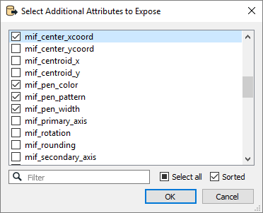
Use this parameter to expose Format Attributes in Workbench when you create a workspace:
- In a dynamic scenario, it means these attributes can be passed to the output dataset at runtime.
- In a non-dynamic scenario, you can use this parameter to expose additional attributes on multiple feature types.

Use Search Envelope
Using the minimum and maximum x and y parameters, define a bounding box that will be used to filter the input features. Only features that intersect with the bounding box are returned.
If all four coordinates of the search envelope are specified as 0, the search envelope will be disabled.
When selected, this parameter removes any portions of imported features being read that are outside the Search Envelope.
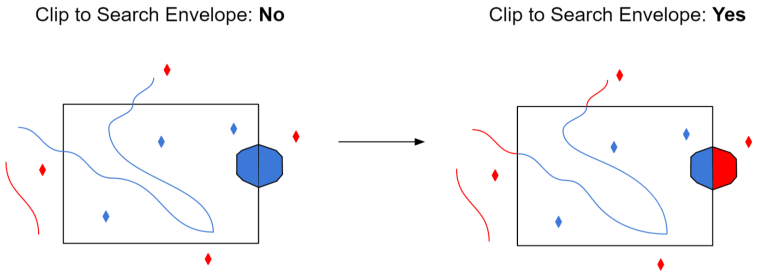
The example below illustrates the results of the Search Envelope when Clip to Search Envelope is not selected (set to No) and when it is selected (set to Yes).
- No: Any features that cross the search envelope boundary will be read, including the portion that lies outside of the boundary.
- Yes: Any features that cross the search envelope boundary will be clipped at the boundary, and only the portion that lies inside the boundary will be read. The underlying function for the Clip to Search Envelope function is an intersection; however, when Clip to Search Envelope is selected, a clipping operation is also performed in addition to the intersection.
