WMS Connection
The URL for the WMS server. A typical URL specifying a WMS server looks like
http://www.fmeserver.com/wms
HTTP Authentication
Note: To access datasets using a proxy server, use the Network tools in FME Options. From the Workbench menu, select Tools > FME Options > Network. For more information, see "Network Proxy" in the FME Workbench Help.
Determines whether or not to use a password-protected HTTP server.
Enter a user name when accessing a password-protected HTTP server.
Enter the password to use when accessing a password-protected HTTP server.
Specify the authentication method (Basic, Digest, or NTLM) to use when accessing a password-protected HTTP server.
HTTP basic access authentication is a mechanism designed to allow a client to provide credentials to a server on the assumption that the connection between them is trusted and secure. That is, any credentials passed from client to server can be easily intercepted through an insecure connection.
Constraints
After you have completely specified the connection, click the Browse button to select layers for import. A connection window appears while the system compiles a table from the database. Once the layer list appears, you can select one or more layers, and then click OK to dismiss the window. The layer name(s) will appear in the layer list field in the Reader Parameters box.
When selected, instructs the WMS reader to split the selected layers into separate HTTP Get Requests. That is, if N layers are selected, then N separate HTTP GetMap requests are performed fetching N images.
Map Options
Sets the background transparency for a map. When this option is selected, and the image format supports transparency (e.g., PNG and GIF), the map server will send an image with transparent background.
Specifies the width in pixels for the image.
Specifies the height in pixels for the image.
Specifies the image output format as a MIME type. The output format must be one of the formats listed in the WMS capabilities document. The directive defaults to “image/png”.
Specifies the desired coordinate system. The default value is “CRS:84” for WMS 1.3.0 and “EPSG:4326” for WMS 1.1.0 and 1.1.1.
Time value or range for map data, expressed using any of the following syntaxes:
| Syntax | Meaning |
|---|---|
value
|
A single value. |
value1,value2,value3,...
|
A list of multiple values. |
min/max/resolution
|
An interval defined by its lower and upper bounds and its resolution. |
min1/max1/res1,min2/max2/res2,... |
A list of multiple intervals. |
Elevation value or range for map data, expressed using any of the following syntaxes:
| Syntax | Meaning |
|---|---|
value
|
A single value. |
value1,value2,value3,...
|
A list of multiple values. |
min/max/resolution
|
An interval defined by its lower and upper bounds and its resolution. |
min1/max1/res1,min2/max2/res2,... |
A list of multiple intervals. |
Schema Attributes
Use this parameter to expose Format Attributes in Workbench when you create a workspace:
- In a dynamic scenario, it means these attributes can be passed to the output dataset at runtime.
- In a non-dynamic scenario where you have multiple feature types, it is convenient to expose additional attributes from one parameter. For example, if you have ten feature types and want to expose the same attribute in each one, it is easier to define it once than it is to set each feature type individually in the workspace.
Using the minimum and maximum x and y parameters, define a bounding box that will be used to filter the input features. Only features that intersect with the bounding box are returned.
If all four coordinates of the search envelope are specified as 0, the search envelope will be disabled.
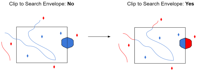
Select this parameter to remove any portions of exported features outside the area of interest.
The illustration below shows the results of the Search Envelope when Clip to Search Envelope is set to No on the left side and Yes on the right side.
- No: Any features that cross the search envelope boundary will be read, including the portion that lies outside of the boundary.
- Yes: Any features that cross the search envelope boundary will be clipped at the boundary, and only the portion that lies inside the boundary will be read. The underlying function for the Clip to Search Envelope function is an intersection; however, when Clip to Search Envelope is set to Yes, a clip is also performed in addition to the intersection.
