FME reads and writes MapInfo files.
The MapInfo Native Format is a proprietary format used by the MapInfo Pro mapping product. MapInfo Native format files are often called TAB files.
This module is closely patterned after the MapInfo MIF/MID reader and writer. This commonality makes it easy to support both MIF and MapInfo Native formats in the same workspace.
Overview
MapInfo is a two-dimensional system with no provision for transferring elevation data for each vertex in a MapInfo feature. However, point features can define an elevation attribute to store their elevation.
MapInfo files store both feature geometry and attributes. A logical MapInfo file consists of several physical files, having the following file name extensions:
|
File Name Extension |
Contents |
|---|---|
|
.tab |
The main file for a MapInfo table, it is associated with the appropriate DAT, MAP, ID, and IND files. |
|
.dat, .dbf, .mdb, .accdb, .xls |
Tabular data for a table in MapInfo’s native format(.dat), dBASE format (.dbf), Microsoft Access format (.mdb or .accdb) or Microsoft Excel format (.xls). Microsoft Access and Microsoft Excel formats are only supported when using the MITAB reader. |
|
.id |
An index to a MapInfo graphical objects (MAP) file. |
|
.map |
Contains geographic information describing map objects. |
|
.ind |
An index to a MapInfo tabular (DAT) file. |
These extensions are added to the basename of the specified MapInfo file. Throughout the remainder of this chapter, references to “file” are references to the logical MapInfo file, not the multiple physical files that make it up.
The MapInfo reader and writer support the storage of point, line, polyline, arc, ellipse, rectangle, rounded rectangle, region (polygon), and text geometric data. The MapInfo format also stores features with no geometry. Features having no geometry are referred to as having a geometry of none.
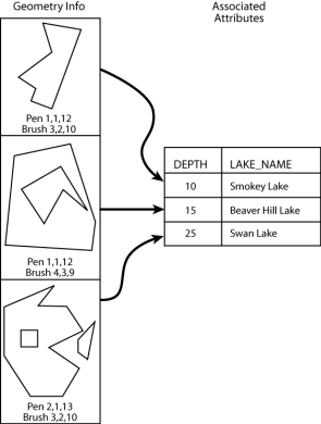
Each geometric entity present in MapInfo has display properties, such as pen and brush width, pattern, and color. In addition, each entity has a row of attributes associated with it. A single MapInfo map file can contain many different types of geometry however, the associated attributes must have the same number and type of fields for each entity in the file.
The MapInfo reader can open datasets in which the attributes are stored as .dat, .dbf, .mdb, .accdb, or .xls files. In other words, the MapInfo reader supports datasets of Type NATIVE, Type DBF, Type ACCESS and Type XLS. Types ACCESS and XLS are only supported when using the MITAB reader.
Note: FME does not directly support MapInfo Grid (.tab .grd) files; however, you can use the NGrid reader to read these files.
The number and type of attributes associated with each entity is specified by the user. There must be at least one attribute field defined before a MapInfo file can be created.
The following illustration shows a MapInfo file containing three region entities. Note that the second polygon contains a hole while the third polygon is an aggregate of two disjoint polygons, one of which contains a hole. Each geometric entity in turn corresponds with one record in the attribute table.
FME considers a MapInfo dataset to be a collection of TAB files and related files in a single folder. The attribute definitions for each MapInfo file set must be defined in the mapping file before it can be read or written.