Action to Take on Update Files
Choosing this option will cause the S-57 reader to apply all updates available for the datasets read. That is, if there are files ending in .011, .002, and so on, in the same folder with base datasets (ending in .000), these update files will be read and applied to the base feature set in accordance with S-57 update rules.
These additional attributes are also added:
|
Attribute Name |
Description |
Defined On |
| s57_update_file{} |
The list of filenames that have been used to update the current feature. These list entries are paired with the s57_update_type field so that together they specify a list update operations from a list of files. For example: s57_update_file{0} = mys57file.001 s57_update_type{0} = INSERT |
Updated features |
| s57_update_type{} |
The list of update types that have been performed on the feature. Possible values are INSERT, MODIFY, or DELETE. These list entries are paired with the s57_update_type field so that together they specify a list update operations from a list of files. For example: s57_update_file{0} = mys57file.001 s57_update_type{0} = MODIFY s57_update_file{1} = mys57file.002 s57_update_type{1} = MODIFY |
Updated features |
For information on all attributes (including generic attributes that appear on all features), see Feature Representation.
Choosing this option will cause the S-57 reader to ignore all updates.
Features
Allows primitives to be read as individual features, whereby each feature has some extra information that could be used in future for writing to a S-57 dataset.
S57 Type
This parameter specifies which enhanced version of S-57 dataset to read. This is used only during schema generation (mapping file or workspace generation) and has no effect during normal reading.
The reader processes the schema according to the selection:
- ENC 3.1 (default): The dataset is interpreted as the original S-57.
- Additional Military Layers 1.0
- Additional Military Layers 2.0
- Inland Waterways
- IENC 2.0
Schema Attributes
Use this parameter to expose Format Attributes in Workbench when you create a workspace:
- In a dynamic scenario, it means these attributes can be passed to the output dataset at runtime.
- In a non-dynamic scenario where you have multiple feature types, it is convenient to expose additional attributes from one parameter. For example, if you have ten feature types and want to expose the same attribute in each one, it is easier to define it once than it is to set each feature type individually in the workspace.
Using the minimum and maximum x and y parameters, define a bounding box that will be used to filter the input features. Only features that intersect with the bounding box are returned.
If all four coordinates of the search envelope are specified as 0, the search envelope will be disabled.
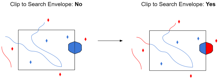
Select this parameter to remove any portions of exported features outside the area of interest.
The illustration below shows the results of the Search Envelope when Clip to Search Envelope is set to No on the left side and Yes on the right side.
- No: Any features that cross the search envelope boundary will be read, including the portion that lies outside of the boundary.
- Yes: Any features that cross the search envelope boundary will be clipped at the boundary, and only the portion that lies inside the boundary will be read. The underlying function for the Clip to Search Envelope function is an intersection; however, when Clip to Search Envelope is set to Yes, a clip is also performed in addition to the intersection.
