FME Transformers: 2026.2
Categories
Cartography and Reports
Format Specific
Rasters
Web
Related Transformers
Clipper
RasterMosaicker
RasterPyramider
RasterSubsetter
Tiler
Creates series of raster tiles for use in web mapping applications such as Bing™ Maps, Google Maps™, or Web Map Tile Service. Tiles are produced at varying zoom levels, size, and resolution.
Typical Uses
- Preparing raster data for use in a web mapping application
How does it work?
The WebMapTiler accepts raster features, and "pyramids" them - resampling and tiling them as necessary to produce a set of raster tiles appropriate for different zoom levels as required by various web mapping tile schemes.
The minimum and maximum zoom level may be specified, or left unset to produce the minimum and maximum level supported by the resolution and size of the input raster(s).
Tile size may be specified for some Tile Schemes. Various methods are available for interpolation of pixel values during resampling.
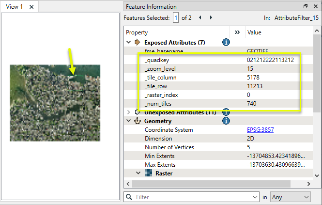
Attributes may be added to the output tiles to record zoom level, tile position, original raster index, number of tiles produced, and Quadkey (used for quad-tree based tile schemes).
This transformer is unaffected by raster band and/or palette selection.
Tile Schemes
Reference
|
Scheme |
Used for |
Projection* |
Tile Size |
Zoom Levels |
||||||||||||||||||||||||||||||||||||||||||||
|---|---|---|---|---|---|---|---|---|---|---|---|---|---|---|---|---|---|---|---|---|---|---|---|---|---|---|---|---|---|---|---|---|---|---|---|---|---|---|---|---|---|---|---|---|---|---|---|---|
|
GoogleMapsCompatible |
Google Maps, Bing Maps, Web Map Tile Service, and ArcGIS. |
EPSG:3857 (Spherical Mercator) |
256x256 pixels |
0 to 23 |
||||||||||||||||||||||||||||||||||||||||||||
|
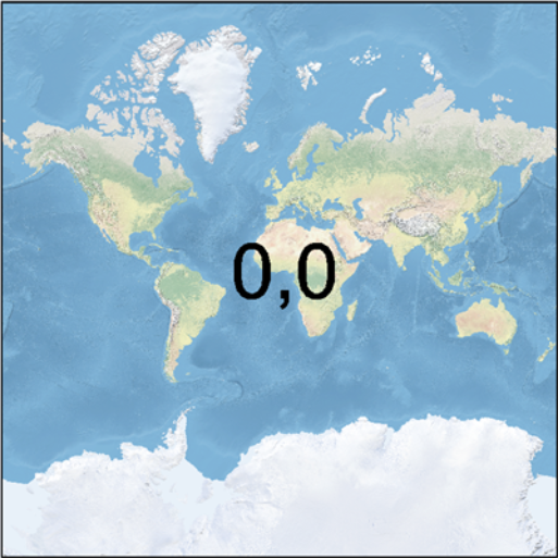
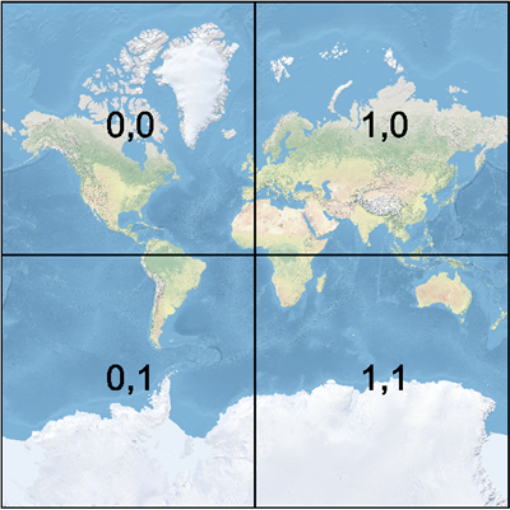
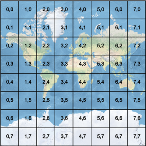
At level 0, the entire world is represented by a 256x256 pixel tile. Each level increases the number of rows and columns by a factor of two: level 1 is 512x512, level 2 is 1024x1024, and so on. The number of tiles is increased accordingly - 1 tile, 4 tiles, 16 tiles, and so on. GoogleMapsCompatible zoom level 0 tiles (column, row):
GoogleMapsCompatible zoom level 1 tiles:
GoogleMapsCompatible zoom level 3 tiles:
|
||||||||||||||||||||||||||||||||||||||||||||||||
|
GoogleCRS84Quad |
Web Map Tile Service |
LL84 |
256x256 pixels |
0 to 18 |
||||||||||||||||||||||||||||||||||||||||||||
|
At level 0, the entire world is represented by a 256x256 pixel tile (where the first and last 64 rows of the tile are blank). Each level increases the number of rows and columns by a factor of two: level 1 is 512x512, level 2 is 1024x1024, and so on. |
||||||||||||||||||||||||||||||||||||||||||||||||
|
GlobalCRS84Scale |
Web Map Tile Service |
LL84 |
user-defined |
0 to 20 |
||||||||||||||||||||||||||||||||||||||||||||
|
Spacing is defined in degrees for each level.
|
||||||||||||||||||||||||||||||||||||||||||||||||
|
GlobalCRS84Pixel |
LL84 |
user-defined |
0 to 17 |
|||||||||||||||||||||||||||||||||||||||||||||
|
This scheme defines a spacing in degrees for each level, as follows:
|
||||||||||||||||||||||||||||||||||||||||||||||||
*Incoming rasters that are not in the required projection will be reprojected by the transformer before tiling is carried out.
Examples
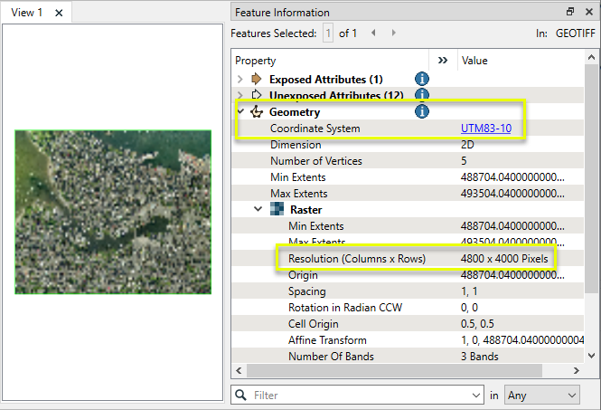
In this example, we prepare a single 4800 x 4000 orthophoto of Vancouver (at 1 meter resolution) for use in Google Maps. The source image is a single GeoTIFF. Note that the projection is UTM83-10 - the transformer will need to reproject it before resampling and tiling.
The raster is routed into a WebMapTiler.
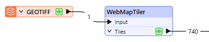
In the parameters dialog, we choose GoogleMapsCompatible as our Tile Scheme.
Note that the Zoom Levels have been left blank. The transformer will calculate the appropriate minimum and maximum levels that can be produced from the input raster.
The zoom levels, as well as the size and position of the tiles for each level, are fixed by Google Maps. The WebMapTiler will adjust the output rasters to fit into these standards.

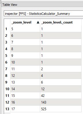
A total of 740 tiles are produced from the original. The number of tiles per zoom level can be analyzed with a StatisticsCalculator.
Note that only zoom levels 5 through 17 have been produced (out of all possible levels, from 0 - the entire earth - to 23 - the smallest possible area of coverage given the original image size and resolution).
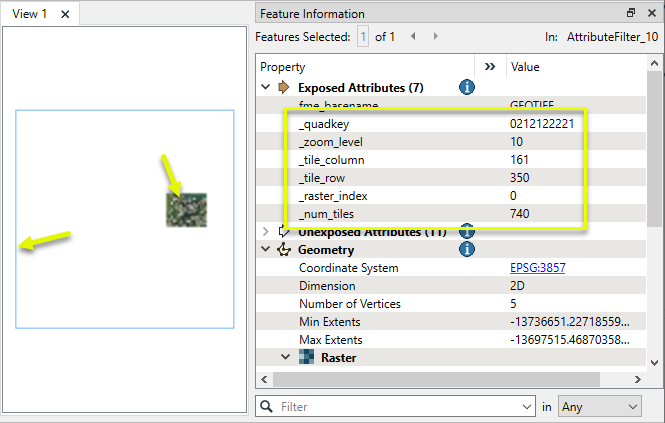
Zoom Level 10
Examining the single tile output for zoom level 10, note the new attributes added including tile position, zoom level, quadkey (used by Google Maps), and more.
The extent of the original raster falls wholly inside the extent of this standard tile’s size and position, so the raster has been padded with blank cells.
A close view of the portion of the raster containing the original shows the resampling to an appropriate (lower) resolution.
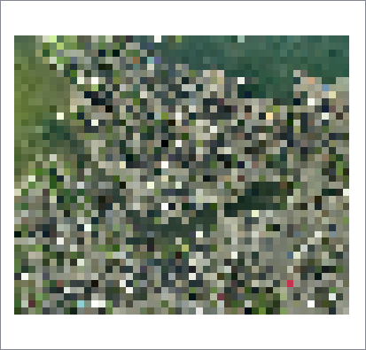
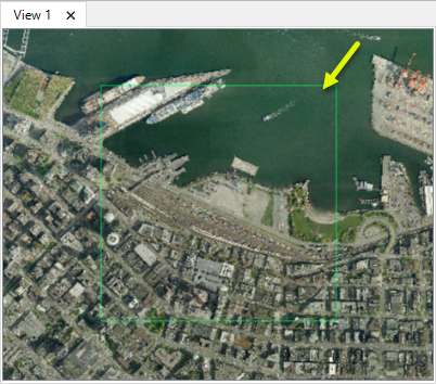
Zoom Level 15
42 tiles were produced for zoom level 15.
A closer look at the selected tile clearly shows that higher resolution is retained for higher zoom levels.
Usage Notes
- To resample rasters using zoom levels and positions that are not tied to one of these web mapping tile schemes, consider using the RasterPyramider.
- Attributes can be used for output file naming - for example the output feature type name can be set to the Quadkey attribute value.
- Generally, when writing out the rasters generated by this transformer, one would set the destination feature type name to be the quadkey value for Bing Maps or a combination of the zoom level, tile column, and tile row for Google Maps. The PNGRASTER writer is recommended for the best results.
- For best performance, rasters output by this transformer should be written in the order they are output. Changing the order (for example, by using Dataset Fanout or a Sorter transformer) may negatively impact performance. Alternatively, use a RasterCheckpointer after the WebMapTiler, but prior to the operation that changes the order.
- When a tile contains areas outside the original raster coverage, an alpha band may be added to the tile to identify these areas. If this band is not desired, it may be removed with the RasterInterpretationCoercer transformer.
Choosing a Raster Transformer
FME has an extensive selection of transformers for working with raster data. They can be generally categorized as working with whole rasters, bands, cells or palettes, and those designed for workflow control or combining raster with vector data.
For information on raster geometry and properties, see Rasters (IFMERaster).
Working with Rasters
|
Sets the cell origin point within cells in a raster. |
|
|
Applies a convolution filter (sometimes called a kernel or lens) to raster features and outputs the results. |
|
|
Enhances the features of a raster image. The RasterDiffuser enhances the borders, lines, and curves while reducing noise in the flat areas of the raster image. |
|
|
Evaluates expressions on each cell in a raster or pair of rasters, including algebraic operations and conditional statements. |
|
|
Replaces the geometry of input raster features with a polygon covering either the extents of a raster or the extent of data within a raster. |
|
|
Extracts Ground Control Point (GCP) coordinate system and point values from a raster feature and exposes them as attributes. |
|
|
Sets Ground Control Points (GCPs) on a raster, pairing cell positions with known coordinates. |
|
|
Georeferences a raster by either known corner coordinates or origin, cell size, and rotation. |
|
|
Generates a grayscale shaded relief representation of terrain, based on elevation values. |
|
|
Alters the interpretation type of rasters, including all bands, and converts cell values if necessary. |
|
|
Merges multiple raster features into a single raster feature. |
|
|
Extracts the geometry properties of a raster feature and exposes them as attributes. |
|
|
Resamples rasters to multiple resolutions, based on either number of levels or dimensions of the smallest output raster. |
|
|
Transforms an image to minimize its difference with another. |
|
|
Resamples rasters, based on specified output dimensions, cell size in ground units, or percentage of original, and interpolates new cell values. |
|
|
Rotates a raster feature according to its rotation angle property, interpolating new cell values, updating all other affected raster properties, and producing an output raster feature with a rotation angle of zero. |
|
|
Clips raster features using pixel bounds instead of ground coordinates, and optionally adds cells around the perimeter. |
|
|
Splits each input raster into a series of tiles by specifying either a tile size in cells/pixels or the number of tiles. |
|
|
Creates polygons from input raster features. One polygon is output for each contiguous area of pixels with the same value in the input raster. |
|
|
Creates a series of image tiles that can be utilized by web mapping applications such as Bing™ Maps, Google Maps™, or Web Map Tile Service. This is done by resampling rasters to various different resolutions and then splitting them into tiles. |
Working with Bands
|
Adds a new band to a raster feature. |
|
|
Merges coincidental raster features into a single output raster feature, preserving and appending all bands. |
|
|
Alters the interpretation type of individual raster bands, converting cell values if necessary. |
|
|
Removes all unselected bands from a raster feature. |
|
|
Extracts the minimum and maximum band values, palette keys, and palette values from a raster feature, and adds them to a list attribute. |
|
|
Sets the band name of selected bands on a raster, making raster contents simpler to understand compared to band numbers. |
|
|
Removes the existing Nodata identifier from selected bands of a raster feature. Any values previously equal to the Nodata value are considered valid data. |
|
|
Sets a new Nodata value on selected bands of a raster feature. |
|
|
Specifies the required order of bands in a raster. Bands are reordered according to the input band indices. |
|
|
Extracts the band and palette properties of a raster feature and exposes them as attributes. |
|
|
Removes any selected bands from a raster feature. |
|
|
Separates bands or unique band and palette combinations, and outputs either individual raster features or a single new raster feature containing all combinations. |
|
|
Calculates statistics on raster bands and adds the results as attributes. |
Working with Cells
|
Calculates the aspect (direction of slope) for each cell of a raster. Aspect is measured in degrees from 0 to 360, clockwise from north. |
|
|
Creates individual points or polygons for each cell in a raster, optionally extracting band values as z coordinates or attributes. |
|
|
Evaluates basic arithmetic , minimum, maximum or average operations on the cell values of a pair of rasters. |
|
|
Replaces a range of band values in a raster with a new single value. |
|
|
Rounds off raster cell values. |
|
|
Partitions a raster image into arbitrarily sized groups of cells from the input image based on intensity differences in the input raster image cells. |
|
|
Performs basic arithmetic operations on the cell values of a raster against a numeric value. |
|
|
Calculates the slope (maximum rate of change in z) for each cell of a raster. |
Working with Palettes
|
Creates a palette from an attribute, and adds this palette to all selected bands on a raster. |
|
|
Creates a string representation of an existing palette on a raster and saves it to an attribute. |
|
|
Generates a palette out of the selected band(s) of a raster. The output raster will have the selected band(s) replaced by a new band with a palette. |
|
|
Alters the interpretation type of raster palettes. |
|
|
Identifies the palette key that matches a raster band’s Nodata value, and sets a value on it. |
|
|
Removes selected palette(s) from raster features. |
|
|
Resolves the palette(s) on a raster by replacing cell values with their corresponding palette values. Palette values with multiple components, such as RGB, are broken down and the individual values assigned to multiple, newly-added bands. |
Workflow Control
|
Forces accumulated raster operations to be processed, saving the state to disk and releasing resources to tune performance or assist with memory limitations. |
|
|
Reads raster features for testing purposes, including any accumulated raster operations. No additional operations are performed, and nothing is done with the features. |
|
|
Serializes the geometry of a raster feature into a Blob attribute, encoding the contents according to a choice of common binary raster formats. |
|
|
Creates a numeric raster of specified size and resolution, with default cell values. |
|
|
Decodes a binary attribute containing encoded rasters stored as Blobs, replacing the feature’s geometry with the decoded raster. |
|
|
Creates a color raster feature of specified size, resolution, and interpretation type, with default cell values. |
|
|
Selects specific bands and palettes of a raster for subsequent transformer operations. |
Vectors and Rasters
|
Creates a raster representation of vector or point cloud input features, using the fme_color attribute over a solid background fill for vector features. Point clouds may be rendered using their color or intensity components. |
|
|
Creates a numeric raster representation of vector or point cloud input features, where cell values are taken from the z coordinates of the input features and overlaid on a uniform background. |
|
|
Generates a raster from input vector and raster features, with fine control over symbolization and labeling, using the Mapnik toolkit. |
|
|
Sets point cloud component values by overlaying a point cloud on a raster. The component values for each point are interpolated from band values at the point location. |
|
|
Extracts the band and palette values from a raster at the location of one or more input points and sets them as attributes on the feature. |
|
|
Produces a raster digital elevation model (DEM) by uniformly sampling a Delaunay triangulation generated from input points and breaklines. |
|
|
Rasterizes vector or point cloud features onto an existing raster. For vector features the fme_color attribute sets pixel color, and point clouds may be rendered using their color or intensity components. |
Configuration
Input Ports
This transformer accepts only raster features.
Output Ports
Tiles with additional attributes, produced according to the selected Tile Scheme and other parameters.
Parameters
|
Tile Scheme |
Choose a method for tiling data. Choices include:
See Tile Schemes above for more detail. |
These parameters specify the zoom levels for which tiles will be generated. Valid values vary by Tile Scheme - see Tile Schemes above for more detail.
If these values are left blank, the transformer will calculate an appropriate range of zoom levels based on the input raster.
|
Minimum Zoom Level |
(Optional) Specify the minimum zoom level to be generated. If Minimum Zoom Level is unspecified, the minimum zoom level will default to the minimum level at which the raster is visible. Note that tiles will not be generated if the input raster covers less than 1 row and 1 column at a particular zoom level, regardless of the minimum zoom level value. |
|
Maximum Zoom Level |
(Optional) Specify the maximum zoom level to be generated. If Maximum Zoom Level is unspecified, the maximum zoom level will be the smallest zoom level such that the resampled raster has more rows or columns than the original raster. |
These parameters specify the size of each output tile for tile schemes that support user-defined sizes.
|
Number of Columns |
Specify the desired tile width in cells (pixels). |
|
Number of Rows |
Specify the desired tile height in cells (pixels). |
|
Interpolation Type |
Cell values are interpolated to produce various raster sizes and resolutions. Choose a method:
|
|
Quadkey |
Name the attribute to contain the quadkey for that tile. Quadkeys are used by Bing Maps to uniquely identify a single tile at a particular level of detail. Note that this attribute will only be created for quad-tree based tile schemes (GoogleMapsCompatible and GoogleCRS84Quad). |
|
Zoom Level |
Name the attribute to contain the zoom level of that tile. |
|
Tile Column |
Name the attribute to contain the column of that tile. |
|
Tile Row |
Name the attribute to contain the row of that tile. |
|
Raster Index |
Name the attribute to contain which raster it was created from. This index is zero-based, so all tiles created from the first input raster will have a value of 0, all tiles created from the second input raster will have a value of 1, etc. |
|
Number of Tiles |
Name the attribute to contain the total number of tiles created from the input raster, across all zoom levels. |
Editing Transformer Parameters
Transformer parameters can be set by directly entering values, using expressions, or referencing other elements in the workspace such as attribute values or user parameters. Various editors and context menus are available to assist. To see what is available, click  beside the applicable parameter.
Defining Values
There are several ways to define a value for use in a Transformer. The simplest is to simply type in a value or string, which can include functions of various types such as attribute references, math and string functions, and workspace parameters.
Using the Text Editor
The Text Editor provides a convenient way to construct text strings (including regular expressions) from various data sources, such as attributes, parameters, and constants, where the result is used directly inside a parameter.
Using the Arithmetic Editor
The Arithmetic Editor provides a convenient way to construct math expressions from various data sources, such as attributes, parameters, and feature functions, where the result is used directly inside a parameter.
Conditional Values
Set values depending on one or more test conditions that either pass or fail.
Parameter Condition Definition Dialog
Content
Expressions and strings can include a number of functions, characters, parameters, and more.
When setting values - whether entered directly in a parameter or constructed using one of the editors - strings and expressions containing String, Math, Date/Time or FME Feature Functions will have those functions evaluated. Therefore, the names of these functions (in the form @<function_name>) should not be used as literal string values.
| These functions manipulate and format strings. | |
|
Special Characters |
A set of control characters is available in the Text Editor. |
| Math functions are available in both editors. | |
| Date/Time Functions | Date and time functions are available in the Text Editor. |
| These operators are available in the Arithmetic Editor. | |
| These return primarily feature-specific values. | |
| FME and workspace-specific parameters may be used. | |
| Creating and Modifying User Parameters | Create your own editable parameters. |
Table Tools
Transformers with table-style parameters have additional tools for populating and manipulating values.
|
Row Reordering
|
Enabled once you have clicked on a row item. Choices include:
|
|
Cut, Copy, and Paste
|
Enabled once you have clicked on a row item. Choices include:
Cut, copy, and paste may be used within a transformer, or between transformers. |
|
Filter
|
Start typing a string, and the matrix will only display rows matching those characters. Searches all columns. This only affects the display of attributes within the transformer - it does not alter which attributes are output. |
|
Import
|
Import populates the table with a set of new attributes read from a dataset. Specific application varies between transformers. |
|
Reset/Refresh
|
Generally resets the table to its initial state, and may provide additional options to remove invalid entries. Behavior varies between transformers. |


Note: Not all tools are available in all transformers.
For more information, see Transformer Parameter Menu Options.
Reference
|
Processing Behavior |
|
|
Feature Holding |
No |
| Dependencies | None |
| Aliases | VirtualEarthTiler |
| History | This transformer was previously named the VirtualEarthTiler. |
FME Online Resources
The FME Community and Support Center Knowledge Base have a wealth of information, including active forums with 35,000+ members and thousands of articles.
Search for all results about the WebMapTiler on the FME Community.
Examples may contain information licensed under the Open Government Licence – Vancouver, Open Government Licence - British Columbia, and/or Open Government Licence – Canada.