FME Transformers: 2025.1
Related Transformers
Affiner
RasterGCPExtractor
RasterGeoreferencer
Sets Ground Control Points (GCPs) on a raster, pairing cell positions with known coordinates.
Typical Uses
- Specifying georeferencing information for rasters such as scanned maps, surveys, and uncorrected aerial images, based on known positions in the source dataset.
How does it work?
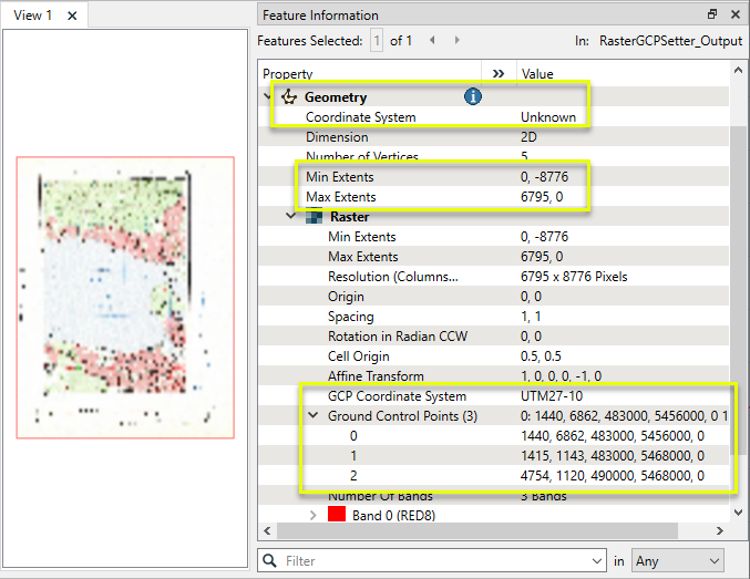
The RasterGCPSetter receives raster features and attaches specified Ground Control Points (GCPs) to them as a raster property.
Each GCP is composed of a pair of positions - the first being a row and column number within the raster, and the second being a known position on the ground, described by a Coordinate System and a set of x,y,z coordinates.
Multiple GCPs may be set with one RasterGCPSetter, and must all be the same coordinate system.
The RasterGCPSetter does not georeference rasters - it only attaches properties that may be used to do so. The GCPs must be applied to the raster to carry out the georeferencing.
A minimum of three GCPs are generally required to georeference a raster. If the raster has already set GCPs, the old GCPs will be overwritten, and so all GCPs must be set in one RasterGCPSetter.
This transformer is unaffected by raster band and palette selection.
GCP Format
Each GCP has five components, separated by spaces:
Column Row X-Coordinate Y-Coordinate Z-Coordinate
For example:
1442 6863 483000 5456000 0
Multiple GCPs are combined into one string, separated by semicolons:
1442 6863 483000 5456000 0;1415 1143 483000 5468000 0;4754 1120 490000 5468000 0
Examples
In this example, we will add Ground Control Points to a scanned map. The original raster is a complete topographical map with grid lines showing northings and eastings.
Note that the raster’s coordinate system is not known - it is not currently georeferenced.
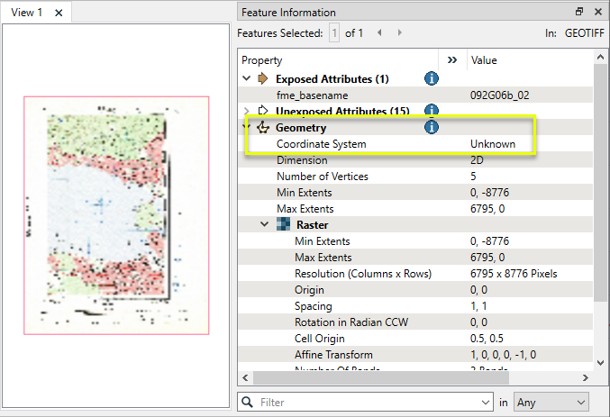
We want at least three GCPs to position the image, and we will identify those prior to configuring the workspace. The coordinate system is UTM27-10, as indicated on the map’s title block.
The first GCP is near the bottom left of the map, where two labeled grid lines intersect. Note that we can identify the cell position (row and column), where the northing and easting intersect.
The first GCP will pair the cell (1440, 6862) with the x,y,z coordinates (483000, 5456000,0). For the purposes of this exercise z is not important, and so is set to zero (0).
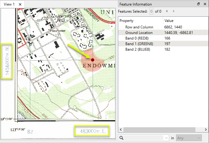
The same process is used to identify GCPs near the upper left and upper right corners of the map. Units are in meters, per the coordinate system identified.
|
GCP |
Cell x (Column) |
Cell y (Row) |
X-Coordinate (Easting) |
Y-Coordinate (Northing) |
Z-Coordinate |
|---|---|---|---|---|---|
|
Lower left |
1440 |
6862 |
483000 |
5456000 |
0 |
|
Upper left |
1415 |
1143 |
483000 |
5468000 |
0 |
|
Upper right |
4754 |
1120 |
490000 |
5468000 |
0 |
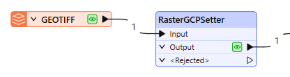
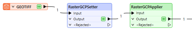
The raster is routed into a RasterGCPSetter.
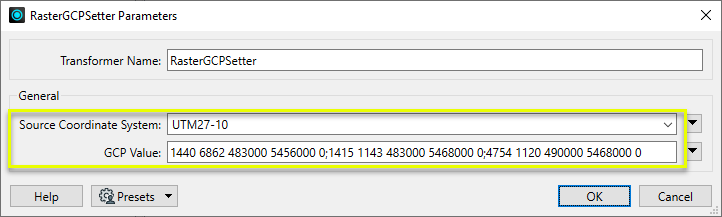
In the parameters dialog, Source Coordinate System is set to UTM27-10.
The GCP Value parameter receives a string containing all of the identified GCPs. Each GCP is composed of five values, separated by spaces:
Column Row X-Coordinate Y-Coordinate Z-Coordinate
The individual GCPs are separated from each other by semicolons, producing this complete string:
1440 6862 483000 5456000 0;1415 1143 483000 5468000 0;4754 1120 490000 5468000 0
The output raster now has the GCPs stored as a property. However, they have not yet been applied to the raster to georeference it.
GCPs can be applied to the raster in appropriate raster format Readers, or in third-party tools that recognize GCPs.
Alternatively, to apply our GCPs, we will use a RasterGCPApplier transformer from the FME Hub.
This transformer has no parameters to configure.
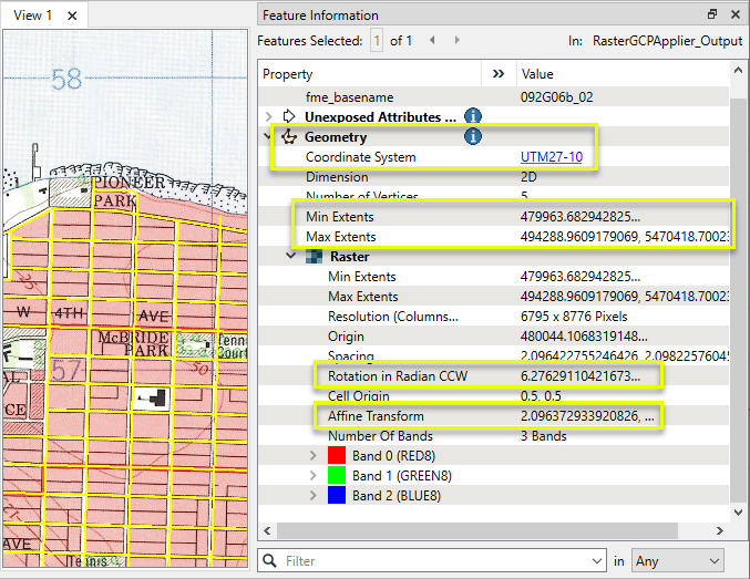
The output raster is georeferenced, with a Coordinate System of UTM27-10 and Extents that reflect valid ground coordinates. It is shown here in the FME Data Inspector with a current streets shapefile overlaid in yellow for context.
Note that the Rotation and Affine Transform values are altered, which indicates the transformations caused by applying the GCPs, and that the GCPs have been removed from the raster properties.
Usage Notes
- To apply GCPs to a raster in FME, you may use the Apply GCPs parameter in raster format Readers that support GCPs. A RasterGCPApplier custom transformer is also available on the FME Hub.
- To extract GCP values from a raster, use the RasterGCPExtractor.
Choosing a Raster Transformer
FME has an extensive selection of transformers for working with raster data. They can be generally categorized as working with whole rasters, bands, cells or palettes, and those designed for workflow control or combining raster with vector data.
For information on raster geometry and properties, see Rasters (IFMERaster).
Working with Rasters
|
Sets the cell origin point within cells in a raster. |
|
|
Applies a convolution filter (sometimes called a kernel or lens) to raster features and outputs the results. |
|
|
Enhances the features of a raster image. The RasterDiffuser enhances the borders, lines, and curves while reducing noise in the flat areas of the raster image. |
|
|
Evaluates expressions on each cell in a raster or pair of rasters, including algebraic operations and conditional statements. |
|
|
Replaces the geometry of input raster features with a polygon covering either the extents of a raster or the extent of data within a raster. |
|
|
Extracts Ground Control Point (GCP) coordinate system and point values from a raster feature and exposes them as attributes. |
|
|
Sets Ground Control Points (GCPs) on a raster, pairing cell positions with known coordinates. |
|
|
Georeferences a raster by either known corner coordinates or origin, cell size, and rotation. |
|
|
Generates a grayscale shaded relief representation of terrain, based on elevation values. |
|
|
Alters the interpretation type of rasters, including all bands, and converts cell values if necessary. |
|
|
Merges multiple raster features into a single raster feature. |
|
|
Extracts the geometry properties of a raster feature and exposes them as attributes. |
|
|
Resamples rasters to multiple resolutions, based on either number of levels or dimensions of the smallest output raster. |
|
|
Transforms an image to minimize its difference with another. |
|
|
Resamples rasters, based on specified output dimensions, cell size in ground units, or percentage of original, and interpolates new cell values. |
|
|
Rotates a raster feature according to its rotation angle property, interpolating new cell values, updating all other affected raster properties, and producing an output raster feature with a rotation angle of zero. |
|
|
Clips raster features using pixel bounds instead of ground coordinates, and optionally adds cells around the perimeter. |
|
|
Splits each input raster into a series of tiles by specifying either a tile size in cells/pixels or the number of tiles. |
|
|
Creates polygons from input raster features. One polygon is output for each contiguous area of pixels with the same value in the input raster. |
|
|
Creates a series of image tiles that can be utilized by web mapping applications such as Bing™ Maps, Google Maps™, or Web Map Tile Service. This is done by resampling rasters to various different resolutions and then splitting them into tiles. |
Working with Bands
|
Adds a new band to a raster feature. |
|
|
Merges coincidental raster features into a single output raster feature, preserving and appending all bands. |
|
|
Alters the interpretation type of individual raster bands, converting cell values if necessary. |
|
|
Removes all unselected bands from a raster feature. |
|
|
Extracts the minimum and maximum band values, palette keys, and palette values from a raster feature, and adds them to a list attribute. |
|
|
Sets the band name of selected bands on a raster, making raster contents simpler to understand compared to band numbers. |
|
|
Removes the existing Nodata identifier from selected bands of a raster feature. Any values previously equal to the Nodata value are considered valid data. |
|
|
Sets a new Nodata value on selected bands of a raster feature. |
|
|
Specifies the required order of bands in a raster. Bands are reordered according to the input band indices. |
|
|
Extracts the band and palette properties of a raster feature and exposes them as attributes. |
|
|
Removes any selected bands from a raster feature. |
|
|
Separates bands or unique band and palette combinations, and outputs either individual raster features or a single new raster feature containing all combinations. |
|
|
Calculates statistics on raster bands and adds the results as attributes. |
Working with Cells
|
Calculates the aspect (direction of slope) for each cell of a raster. Aspect is measured in degrees from 0 to 360, clockwise from north. |
|
|
Creates individual points or polygons for each cell in a raster, optionally extracting band values as z coordinates or attributes. |
|
|
Evaluates basic arithmetic , minimum, maximum or average operations on the cell values of a pair of rasters. |
|
|
Replaces a range of band values in a raster with a new single value. |
|
|
Rounds off raster cell values. |
|
|
Partitions a raster image into arbitrarily sized groups of cells from the input image based on intensity differences in the input raster image cells. |
|
|
Performs basic arithmetic operations on the cell values of a raster against a numeric value. |
|
|
Calculates the slope (maximum rate of change in z) for each cell of a raster. |
Working with Palettes
|
Creates a palette from an attribute, and adds this palette to all selected bands on a raster. |
|
|
Creates a string representation of an existing palette on a raster and saves it to an attribute. |
|
|
Generates a palette out of the selected band(s) of a raster. The output raster will have the selected band(s) replaced by a new band with a palette. |
|
|
Alters the interpretation type of raster palettes. |
|
|
Identifies the palette key that matches a raster band’s Nodata value, and sets a value on it. |
|
|
Removes selected palette(s) from raster features. |
|
|
Resolves the palette(s) on a raster by replacing cell values with their corresponding palette values. Palette values with multiple components, such as RGB, are broken down and the individual values assigned to multiple, newly-added bands. |
Workflow Control
|
Forces accumulated raster operations to be processed, saving the state to disk and releasing resources to tune performance or assist with memory limitations. |
|
|
Reads raster features for testing purposes, including any accumulated raster operations. No additional operations are performed, and nothing is done with the features. |
|
|
Serializes the geometry of a raster feature into a Blob attribute, encoding the contents according to a choice of common binary raster formats. |
|
|
Creates a numeric raster of specified size and resolution, with default cell values. |
|
|
Decodes a binary attribute containing encoded rasters stored as Blobs, replacing the feature’s geometry with the decoded raster. |
|
|
Creates a color raster feature of specified size, resolution, and interpretation type, with default cell values. |
|
|
Selects specific bands and palettes of a raster for subsequent transformer operations. |
Vectors and Rasters
|
Creates a raster representation of vector or point cloud input features, using the fme_color attribute over a solid background fill for vector features. Point clouds may be rendered using their color or intensity components. |
|
|
Creates a numeric raster representation of vector or point cloud input features, where cell values are taken from the z coordinates of the input features and overlaid on a uniform background. |
|
|
Generates a raster from input vector and raster features, with fine control over symbolization and labeling, using the Mapnik toolkit. |
|
|
Sets point cloud component values by overlaying a point cloud on a raster. The component values for each point are interpolated from band values at the point location. |
|
|
Extracts the band and palette values from a raster at the location of one or more input points and sets them as attributes on the feature. |
|
|
Produces a raster digital elevation model (DEM) by uniformly sampling a Delaunay triangulation generated from input points and breaklines. |
|
|
Rasterizes vector or point cloud features onto an existing raster. For vector features the fme_color attribute sets pixel color, and point clouds may be rendered using their color or intensity components. |
Configuration
Input Ports
This transformer accepts only raster features.
Output Ports
Raster features with GCPs stored as raster properties, as specified in the parameters dialog.
Non-raster features will be routed to the <Rejected> port, as well as invalid rasters.
Rejected features will have an fme_rejection_code attribute with one of the following values:
INVALID_GEOMETRY_TYPE
Rejected Feature Handling: can be set to either terminate the translation or continue running when it encounters a rejected feature. This setting is available both as a default FME option and as a workspace parameter.
Parameters
|
Source Coordinate System |
Select the coordinate system that would be effective if the Ground Control Points were applied to the raster. This is not necessarily equivalent to the coordinate system of the raster feature. |
|
GCP Value |
A string value specifying the GCPs. Each GCP has five components, separated by spaces: Column Row X-Coordinate Y-Coordinate Z-Coordinate For example: 1442 6863 483000 5456000 0 Multiple GCPs are combined into one string, separated by semicolons: 1442 6863 483000 5456000 0;1415 1143 483000 5468000 0;4754 1120 490000 5468000 0 |
Editing Transformer Parameters
Transformer parameters can be set by directly entering values, using expressions, or referencing other elements in the workspace such as attribute values or user parameters. Various editors and context menus are available to assist. To see what is available, click  beside the applicable parameter.
Defining Values
There are several ways to define a value for use in a Transformer. The simplest is to simply type in a value or string, which can include functions of various types such as attribute references, math and string functions, and workspace parameters.
Using the Text Editor
The Text Editor provides a convenient way to construct text strings (including regular expressions) from various data sources, such as attributes, parameters, and constants, where the result is used directly inside a parameter.
Using the Arithmetic Editor
The Arithmetic Editor provides a convenient way to construct math expressions from various data sources, such as attributes, parameters, and feature functions, where the result is used directly inside a parameter.
Conditional Values
Set values depending on one or more test conditions that either pass or fail.
Parameter Condition Definition Dialog
Content
Expressions and strings can include a number of functions, characters, parameters, and more.
When setting values - whether entered directly in a parameter or constructed using one of the editors - strings and expressions containing String, Math, Date/Time or FME Feature Functions will have those functions evaluated. Therefore, the names of these functions (in the form @<function_name>) should not be used as literal string values.
| These functions manipulate and format strings. | |
|
Special Characters |
A set of control characters is available in the Text Editor. |
| Math functions are available in both editors. | |
| Date/Time Functions | Date and time functions are available in the Text Editor. |
| These operators are available in the Arithmetic Editor. | |
| These return primarily feature-specific values. | |
| FME and workspace-specific parameters may be used. | |
| Creating and Modifying User Parameters | Create your own editable parameters. |
Table Tools
Transformers with table-style parameters have additional tools for populating and manipulating values.
|
Row Reordering
|
Enabled once you have clicked on a row item. Choices include:
|
|
Cut, Copy, and Paste
|
Enabled once you have clicked on a row item. Choices include:
Cut, copy, and paste may be used within a transformer, or between transformers. |
|
Filter
|
Start typing a string, and the matrix will only display rows matching those characters. Searches all columns. This only affects the display of attributes within the transformer - it does not alter which attributes are output. |
|
Import
|
Import populates the table with a set of new attributes read from a dataset. Specific application varies between transformers. |
|
Reset/Refresh
|
Generally resets the table to its initial state, and may provide additional options to remove invalid entries. Behavior varies between transformers. |


Note: Not all tools are available in all transformers.
For more information, see Transformer Parameter Menu Options.
Reference
|
Processing Behavior |
|
|
Feature Holding |
No |
| Dependencies | None |
| Aliases | |
| History |
FME Community
The FME Community has a wealth of FME knowledge with over 20,000 active members worldwide. Get help with FME, share knowledge, and connect with users globally.
Search for all results about the RasterGCPSetter on the FME Community.
Examples may contain information licensed under the Open Government Licence – Vancouver, Open Government Licence - British Columbia, and/or Open Government Licence – Canada.