FME Transformers: 2025.0
Related Transformers
FeatureColorSetter
MapnikRasterizer
NumericRasterizer
RasterNumericCreator
RasterRGBCreator
VectorOnRasterOverlayer
Creates a raster representation of vector or point cloud input features.
For vector features the fme_color attribute sets pixel color, over a solid background fill. Point clouds may be rendered using their color or intensity components.
Typical Uses
- Creating raster images from vector data with a simple, solid background.
- Creating raster representations of point cloud data, using either color or intensity.
How does it work?
The ImageRasterizer receives point, line, and area geometries or point clouds, and “draws” them onto a single output raster feature.
For vector input features, the fme_color attribute determines the pixel color in the raster. Line weights are not supported, and features will be drawn at a width of one (1) pixel.
Polygon features that do not have a fill color defined (fme_fill_color) will be filled with their outline color (fme_color).
For point clouds, pixel coloring may be done using either the color or intensity component.
Background fill color, alpha value, and Nodata options are available, as well as anti-aliasing. A variety of options is available for raster interpretation, including RGB variants, gray scales, and single color and alpha bands.
The size of the output raster may be defined by number of rows and columns, or by specifying the size of a single cell (pixel) in ground units. The geographic extent covered by the raster may be either determined by the input features or manually specified.
Features with no color attribute (or point clouds without an intensity component, if selected) will be discarded and output via the <Rejected> port.
Examples
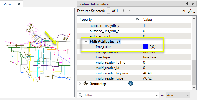
In this example, we will create a raster representation of a DWG file containing bike path lines. As the CAD file has a color attribute already associated with each line, FME assigns that color to the fme_color attribute on reading. (Other formats may need to have colors assigned in the workspace - consider using the FeatureColorSetter).
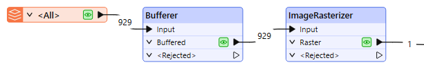
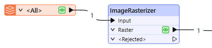
The bike path features are routed into a Bufferer, and then to an ImageRasterizer.
The buffer amount is set to 25 (meters, in ground units), producing polygons that will be more visible in the output raster than single-pixel width lines.
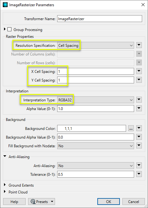
In the parameters dialog, we set the output raster size to be calculated at 1 cell (pixel) per meter (ground units), both vertically and horizontally. The Interpretation Type is RGBA32, and the default settings producing a white background, and anti-aliasing turned off.
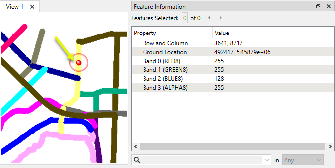
One raster feature is output.
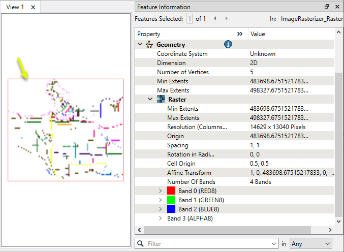
A closer look shows the shapes of the buffered lines. The selected cell’s attributes include RGBA color values.
LiDAR intensity values can be used to create a raster that resembles black-and-white imagery, useful for context when conventional imagery isn’t available.
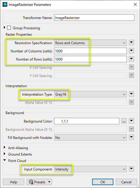
In this example, we start by routing the LAS data into an ImageRasterizer.
In the parameters dialog, we specify the size of the output raster - this time, defining the output dimensions in overall height and width of 1000 by 1000 cells (pixels). Interpretation Type is set to Gray16, and the Point Cloud Input Component is Intensity.
Note that a point cloud intensity raster can be written to any of the Interpretation Types, including color, but will still appear as a gray scale (with according individual band values).
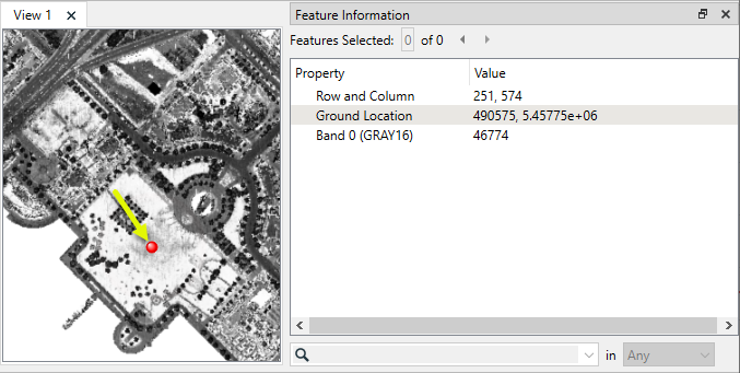
The output raster represents intensity values on a gray scale.
Usage Notes
- Lines and points may be buffered prior to entering the transformer to increase their visibility if necessary, which would depend on the output raster size, intended viewing scale, and feature size. Some experimentation may be necessary, using the Bufferer.
- To produce elevation rasters, use the NumericRasterizer.
- To overlay vector features onto an existing raster, use the VectorOnRasterOverlayer.
- For fine control over vector styling for raster output, consider using the MapnikRasterizer.
- When rasterizing point clouds, all points are processed, in the order they occur within the point cloud. Depending on the resolution of the raster, multiple points may fall within a cell. As all are processed, the last point encountered within a cell will provide the band values. The PointCloudSorter may be useful to prepare the point cloud.
Choosing a Raster Transformer
FME has an extensive selection of transformers for working with raster data. They can be generally categorized as working with whole rasters, bands, cells or palettes, and those designed for workflow control or combining raster with vector data.
For information on raster geometry and properties, see Rasters (IFMERaster).
Working with Rasters
|
Sets the cell origin point within cells in a raster. |
|
|
Applies a convolution filter (sometimes called a kernel or lens) to raster features and outputs the results. |
|
|
Enhances the features of a raster image. The RasterDiffuser enhances the borders, lines, and curves while reducing noise in the flat areas of the raster image. |
|
|
Evaluates expressions on each cell in a raster or pair of rasters, including algebraic operations and conditional statements. |
|
|
Replaces the geometry of input raster features with a polygon covering either the extents of a raster or the extent of data within a raster. |
|
|
Extracts Ground Control Point (GCP) coordinate system and point values from a raster feature and exposes them as attributes. |
|
|
Sets Ground Control Points (GCPs) on a raster, pairing cell positions with known coordinates. |
|
|
Georeferences a raster by either known corner coordinates or origin, cell size, and rotation. |
|
|
Generates a grayscale shaded relief representation of terrain, based on elevation values. |
|
|
Alters the interpretation type of rasters, including all bands, and converts cell values if necessary. |
|
|
Merges multiple raster features into a single raster feature. |
|
|
Extracts the geometry properties of a raster feature and exposes them as attributes. |
|
|
Resamples rasters to multiple resolutions, based on either number of levels or dimensions of the smallest output raster. |
|
|
Transforms an image to minimize its difference with another. |
|
|
Resamples rasters, based on specified output dimensions, cell size in ground units, or percentage of original, and interpolates new cell values. |
|
|
Rotates a raster feature according to its rotation angle property, interpolating new cell values, updating all other affected raster properties, and producing an output raster feature with a rotation angle of zero. |
|
|
Clips raster features using pixel bounds instead of ground coordinates, and optionally adds cells around the perimeter. |
|
|
Splits each input raster into a series of tiles by specifying either a tile size in cells/pixels or the number of tiles. |
|
|
Creates polygons from input raster features. One polygon is output for each contiguous area of pixels with the same value in the input raster. |
|
|
Creates a series of image tiles that can be utilized by web mapping applications such as Bing™ Maps, Google Maps™, or Web Map Tile Service. This is done by resampling rasters to various different resolutions and then splitting them into tiles. |
Working with Bands
|
Adds a new band to a raster feature. |
|
|
Merges coincidental raster features into a single output raster feature, preserving and appending all bands. |
|
|
Alters the interpretation type of individual raster bands, converting cell values if necessary. |
|
|
Removes all unselected bands from a raster feature. |
|
|
Extracts the minimum and maximum band values, palette keys, and palette values from a raster feature, and adds them to a list attribute. |
|
|
Sets the band name of selected bands on a raster, making raster contents simpler to understand compared to band numbers. |
|
|
Removes the existing Nodata identifier from selected bands of a raster feature. Any values previously equal to the Nodata value are considered valid data. |
|
|
Sets a new Nodata value on selected bands of a raster feature. |
|
|
Specifies the required order of bands in a raster. Bands are reordered according to the input band indices. |
|
|
Extracts the band and palette properties of a raster feature and exposes them as attributes. |
|
|
Removes any selected bands from a raster feature. |
|
|
Separates bands or unique band and palette combinations, and outputs either individual raster features or a single new raster feature containing all combinations. |
|
|
Calculates statistics on raster bands and adds the results as attributes. |
Working with Cells
|
Calculates the aspect (direction of slope) for each cell of a raster. Aspect is measured in degrees from 0 to 360, clockwise from north. |
|
|
Creates individual points or polygons for each cell in a raster, optionally extracting band values as z coordinates or attributes. |
|
|
Evaluates basic arithmetic , minimum, maximum or average operations on the cell values of a pair of rasters. |
|
|
Replaces a range of band values in a raster with a new single value. |
|
|
Rounds off raster cell values. |
|
|
Partitions a raster image into arbitrarily sized groups of cells from the input image based on intensity differences in the input raster image cells. |
|
|
Performs basic arithmetic operations on the cell values of a raster against a numeric value. |
|
|
Calculates the slope (maximum rate of change in z) for each cell of a raster. |
Working with Palettes
|
Creates a palette from an attribute, and adds this palette to all selected bands on a raster. |
|
|
Creates a string representation of an existing palette on a raster and saves it to an attribute. |
|
|
Generates a palette out of the selected band(s) of a raster. The output raster will have the selected band(s) replaced by a new band with a palette. |
|
|
Alters the interpretation type of raster palettes. |
|
|
Identifies the palette key that matches a raster band’s Nodata value, and sets a value on it. |
|
|
Removes selected palette(s) from raster features. |
|
|
Resolves the palette(s) on a raster by replacing cell values with their corresponding palette values. Palette values with multiple components, such as RGB, are broken down and the individual values assigned to multiple, newly-added bands. |
Workflow Control
|
Forces accumulated raster operations to be processed, saving the state to disk and releasing resources to tune performance or assist with memory limitations. |
|
|
Reads raster features for testing purposes, including any accumulated raster operations. No additional operations are performed, and nothing is done with the features. |
|
|
Serializes the geometry of a raster feature into a Blob attribute, encoding the contents according to a choice of common binary raster formats. |
|
|
Creates a numeric raster of specified size and resolution, with default cell values. |
|
|
Decodes a binary attribute containing encoded rasters stored as Blobs, replacing the feature’s geometry with the decoded raster. |
|
|
Creates a color raster feature of specified size, resolution, and interpretation type, with default cell values. |
|
|
Selects specific bands and palettes of a raster for subsequent transformer operations. |
Vectors and Rasters
|
Creates a raster representation of vector or point cloud input features, using the fme_color attribute over a solid background fill for vector features. Point clouds may be rendered using their color or intensity components. |
|
|
Creates a numeric raster representation of vector or point cloud input features, where cell values are taken from the z coordinates of the input features and overlaid on a uniform background. |
|
|
Generates a raster from input vector and raster features, with fine control over symbolization and labeling, using the Mapnik toolkit. |
|
|
Sets point cloud component values by overlaying a point cloud on a raster. The component values for each point are interpolated from band values at the point location. |
|
|
Extracts the band and palette values from a raster at the location of one or more input points and sets them as attributes on the feature. |
|
|
Produces a raster digital elevation model (DEM) by uniformly sampling a Delaunay triangulation generated from input points and breaklines. |
|
|
Rasterizes vector or point cloud features onto an existing raster. For vector features the fme_color attribute sets pixel color, and point clouds may be rendered using their color or intensity components. |
Configuration
Input Ports
The Input port accepts vector or point cloud features to be rasterized. Vector features must have an fme_color attribute. Point clouds must have either a color or intensity component.
Output Ports
The raster drawn according to parameter selections.
Invalid features will be routed to the <Rejected> port.
Rejected features will have an fme_rejection_code attribute with one of the following values:
INVALID_VECTOR_GEOMETRY_TYPE
INVALID_VECTOR_GEOMETRY_COLOR
Rejected Feature Handling: can be set to either terminate the translation or continue running when it encounters a rejected feature. This setting is available both as a default FME option and as a workspace parameter.
Parameters
|
Group By |
If the Group By parameter is set to an attribute list, one raster per group will be produced. |
||||
|
Complete Groups |
Select the point in processing at which groups are processed:
There are two typical reasons for using When Group Changes (Advanced) . The first is incoming data that is intended to be processed in groups (and is already so ordered). In this case, the structure dictates Group By usage - not performance considerations. The second possible reason is potential performance gains. Performance gains are most likely when the data is already sorted (or read using a SQL ORDER BY statement) since less work is required of FME. If the data needs ordering, it can be sorted in the workspace (though the added processing overhead may negate any gains). Sorting becomes more difficult according to the number of data streams. Multiple streams of data could be almost impossible to sort into the correct order, since all features matching a Group By value need to arrive before any features (of any feature type or dataset) belonging to the next group. In this case, using Group By with When All Features Received may be the equivalent and simpler approach. Note Multiple feature types and features from multiple datasets will not generally naturally occur in the correct order.
As with many scenarios, testing different approaches in your workspace with your data is the only definitive way to identify performance gains. |
|
Resolution Specification |
Select a method of defining output raster size:
|
|
Number of Columns (cells) |
If Resolution Specification is Rows and Columns, enter the width of the output raster in cells (pixels). |
|
Number of Rows (cells) |
If Resolution Specification is Rows and Columns, enter the height of the output raster in cells (pixels). |
|
X Cell Spacing |
If Resolution Specification is Cell Spacing, enter the width in ground units of a single cell (pixel). |
|
Y Cell Spacing |
If Resolution Specification is Cell Spacing, enter the height in ground units of a single cell (pixel). |
|
Interpretation Type |
Select an interpretation for the output raster. Options include:
|
|
Alpha Value |
Set a value for alpha bands, between 0 and 1, where 0 is fully transparent and 1 is fully opaque. |
|
Background Color |
Sets the background color for the raster. Specifying Colors Colors may be entered directly or chosen from the color picker via the ellipsis button. Colors can be specified by RGB values or hex codes. RGB values may be either 24-bit or decimal (0 - 1). If the value type is unclear, the 24-bit interpretation is used. Hex codes are accepted with or without a hash sign (#).
|
||||||||||||||||||||
|
Background Alpha Value |
Sets the background value for any alpha bands on the raster. It must be a number between 0 and 1, where 0 is fully transparent and 1 is fully opaque. |
||||||||||||||||||||
|
Fill Background with Nodata |
If Yes, the background color will also be flagged as the Nodata value for each raster band. |


|
Anti-Aliasing |
If Yes, the output lines will be smoothed using an anti-aliasing algorithm. |
|
Tolerance |
The Tolerance parameter is the maximum normalized distance from a line segment or polygon vertex to a pixel to be rendered. For example a tolerance of 1.0 will draw all pixels touched by the input vector line, while a tolerance of 0.0 will draw only those pixels where the input vector line passes directly through their center. Tolerance can only be selected when anti-aliasing is set to No. |
|
Ground Extents |
If Use input data ground extents, the extents are not explicitly specified, and the output raster extents will be determined by the union of the bounding boxes of the valid input vector features. If Specify ground extents, the remaining Ground Extents parameters are used to specify the extents of the output raster. The output raster will be clipped to the specified extents. |
|
Minimum X |
This specifies the minimum x value of the output raster. It is used when the Ground Extents parameter is set to Specify ground extents. |
|
Minimum Y |
This specifies the minimum y value of the output raster. It is used when the Ground Extents parameter is set to Specify ground extents. |
|
Maximum X |
This specifies the maximum x value of the output raster. It is used when the Ground Extents parameter is set to Specify ground extents. |
|
Maximum Y |
This specifies the maximum y value of the output raster. It is used when the Ground Extents parameter is set to Specify ground extents. |
|
Input Component |
When drawing point clouds on color bands, the Input Component specifies which component of the point should be used to set the color of the raster pixel. If Color, the points in the cloud must have a color component. If Intensity, the points in the cloud must have an intensity component. The intensity component is converted to a color using a grayscale continuum, where the minimum intensity in the cloud is black and the maximum intensity in the cloud is white. |
Editing Transformer Parameters
Transformer parameters can be set by directly entering values, using expressions, or referencing other elements in the workspace such as attribute values or user parameters. Various editors and context menus are available to assist. To see what is available, click  beside the applicable parameter.
Defining Values
There are several ways to define a value for use in a Transformer. The simplest is to simply type in a value or string, which can include functions of various types such as attribute references, math and string functions, and workspace parameters.
Using the Text Editor
The Text Editor provides a convenient way to construct text strings (including regular expressions) from various data sources, such as attributes, parameters, and constants, where the result is used directly inside a parameter.
Using the Arithmetic Editor
The Arithmetic Editor provides a convenient way to construct math expressions from various data sources, such as attributes, parameters, and feature functions, where the result is used directly inside a parameter.
Conditional Values
Set values depending on one or more test conditions that either pass or fail.
Parameter Condition Definition Dialog
Content
Expressions and strings can include a number of functions, characters, parameters, and more.
When setting values - whether entered directly in a parameter or constructed using one of the editors - strings and expressions containing String, Math, Date/Time or FME Feature Functions will have those functions evaluated. Therefore, the names of these functions (in the form @<function_name>) should not be used as literal string values.
| These functions manipulate and format strings. | |
|
Special Characters |
A set of control characters is available in the Text Editor. |
| Math functions are available in both editors. | |
| Date/Time Functions | Date and time functions are available in the Text Editor. |
| These operators are available in the Arithmetic Editor. | |
| These return primarily feature-specific values. | |
| FME and workspace-specific parameters may be used. | |
| Creating and Modifying User Parameters | Create your own editable parameters. |
Table Tools
Transformers with table-style parameters have additional tools for populating and manipulating values.
|
Row Reordering
|
Enabled once you have clicked on a row item. Choices include:
|
|
Cut, Copy, and Paste
|
Enabled once you have clicked on a row item. Choices include:
Cut, copy, and paste may be used within a transformer, or between transformers. |
|
Filter
|
Start typing a string, and the matrix will only display rows matching those characters. Searches all columns. This only affects the display of attributes within the transformer - it does not alter which attributes are output. |
|
Import
|
Import populates the table with a set of new attributes read from a dataset. Specific application varies between transformers. |
|
Reset/Refresh
|
Generally resets the table to its initial state, and may provide additional options to remove invalid entries. Behavior varies between transformers. |


Note: Not all tools are available in all transformers.
For more information, see Transformer Parameter Menu Options.
Reference
|
Processing Behavior |
|
|
Feature Holding |
Yes |
| Dependencies | None |
| Aliases | Rasterizer |
| History |
FME Community
The FME Community has a wealth of FME knowledge with over 20,000 active members worldwide. Get help with FME, share knowledge, and connect with users globally.
Search for all results about the ImageRasterizer on the FME Community.
Examples may contain information licensed under the Open Government Licence – Vancouver, Open Government Licence - British Columbia, and/or Open Government Licence – Canada.