FME Transformers: 2026.2
Categories
Coordinates
Related Transformers
GeometryExtractor
GeometryReplacer
MGRSToLatLongConverter
Calculates a Military Grid Reference System (MGRS) code based on latitude and longitude values.
Typical Uses
-
Determining which standard MGRS boundary contains a given point.
How does it work?
The LatLongToMGRSConverter accepts any feature. The user specifies attributes, expressions, or user parameters containing latitude and longitude coordinates, along with the Ellipsoid and desired Lettering Type.
The standard MGRS code is generated to the specified Precision, and stored as an attribute.
Precision is an integer from 0 to 5 (inclusive). A precision of 5 locates a point within a 1-meter square and precision of 0 locates a point within 100-km square.
Examples
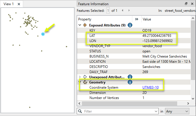
In this example, we have a shapefile of food vendor locations, and want to generate MGRS codes for each location.
Note that although the dataset is in a UTM coordinate system with ground units in meters, it also has a set of coordinates, latitude and longitude, stored as attributes.
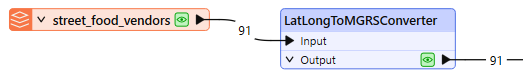
The features are routed into a LatLongToMGRSConverter.
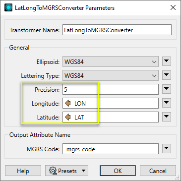
In the parameters dialog, Precision is set to 5, and the Longitude and Latitude parameters are set to the appropriate attributes.
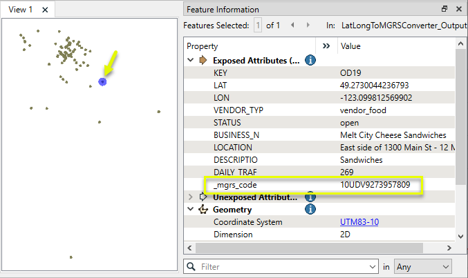
The output features have a new attribute containing the resulting code.
Usage Notes
-
For more information on the MGRS, see Military Grid Reference System.
-
This transformer does not operate on geometry. To extract coordinates from geometry for conversion, consider using the CoordinateExtractor or @XValue() and @YValue() functions.
Configuration
Input Ports
Features with latitude and longitude coordinates available as attributes, expressions, or user parameters.
Output Ports
Features with an MGRS code generated according to parameter selections and added to an attribute.
Parameters
|
Ellipsoid |
The ellipsoid used for the conversion. This can be any ellipsoid name supported by FME. |
||||||||||||||
|
Lettering Type |
Select a type:
|
||||||||||||||
|
Precision |
Specify the granularity of the resulting code an integer from 0 to 5.
|
||||||||||||||
|
Longitude |
Supply a longitude value by providing an attribute name, expression, or user parameter. |
||||||||||||||
|
Latitude |
Supply a latitude value by providing an attribute name, expression, or user parameter. |
|
MGRS Code |
Name the attribute to contain the generated MGRS code. |
Editing Transformer Parameters
Transformer parameters can be set by directly entering values, using expressions, or referencing other elements in the workspace such as attribute values or user parameters. Various editors and context menus are available to assist. To see what is available, click  beside the applicable parameter.
Defining Values
There are several ways to define a value for use in a Transformer. The simplest is to simply type in a value or string, which can include functions of various types such as attribute references, math and string functions, and workspace parameters.
Using the Text Editor
The Text Editor provides a convenient way to construct text strings (including regular expressions) from various data sources, such as attributes, parameters, and constants, where the result is used directly inside a parameter.
Using the Arithmetic Editor
The Arithmetic Editor provides a convenient way to construct math expressions from various data sources, such as attributes, parameters, and feature functions, where the result is used directly inside a parameter.
Conditional Values
Set values depending on one or more test conditions that either pass or fail.
Parameter Condition Definition Dialog
Content
Expressions and strings can include a number of functions, characters, parameters, and more.
When setting values - whether entered directly in a parameter or constructed using one of the editors - strings and expressions containing String, Math, Date/Time or FME Feature Functions will have those functions evaluated. Therefore, the names of these functions (in the form @<function_name>) should not be used as literal string values.
| These functions manipulate and format strings. | |
|
Special Characters |
A set of control characters is available in the Text Editor. |
| Math functions are available in both editors. | |
| Date/Time Functions | Date and time functions are available in the Text Editor. |
| These operators are available in the Arithmetic Editor. | |
| These return primarily feature-specific values. | |
| FME and workspace-specific parameters may be used. | |
| Creating and Modifying User Parameters | Create your own editable parameters. |
Table Tools
Transformers with table-style parameters have additional tools for populating and manipulating values.
|
Row Reordering
|
Enabled once you have clicked on a row item. Choices include:
|
|
Cut, Copy, and Paste
|
Enabled once you have clicked on a row item. Choices include:
Cut, copy, and paste may be used within a transformer, or between transformers. |
|
Filter
|
Start typing a string, and the matrix will only display rows matching those characters. Searches all columns. This only affects the display of attributes within the transformer - it does not alter which attributes are output. |
|
Import
|
Import populates the table with a set of new attributes read from a dataset. Specific application varies between transformers. |
|
Reset/Refresh
|
Generally resets the table to its initial state, and may provide additional options to remove invalid entries. Behavior varies between transformers. |


Note: Not all tools are available in all transformers.
For more information, see Transformer Parameter Menu Options.
Reference
|
Processing Behavior |
|
|
Feature Holding |
No |
| Dependencies | None |
| Aliases | |
| History |
FME Online Resources
The FME Community and Support Center Knowledge Base have a wealth of information, including active forums with 35,000+ members and thousands of articles.
Search for all results about the LatLongToMGRSConverter on the FME Community.
Examples may contain information licensed under the Open Government Licence – Vancouver, Open Government Licence - British Columbia, and/or Open Government Licence – Canada.