Dataset
The file from which the data is to be read.
Constraints
After you have specified the database connection, click the Browse button to select tables for import. A connection window appears while the system compiles a table from the database.
Once the table list appears, you can select one or more tables, and then click OK to dismiss the window. The table name(s) will appear in the Table List field in the parameter box.
Specifies whether to resolve attributes that have a default coded value domain (i.e., the domain was not set up through a subtype) associated with them. This means that when an attribute of a feature has a coded value domain associated with it, another attribute will also be added that represents the textual description of the coded attribute.
The new attribute will be <attribute-name>_resolved, where <attribute-name> is the name of the attribute containing the code.
Specifies whether to read only those features that are within the extents of the map document, or to ignore the extents and read all the features in the layer.
Specifies whether to read features from an invisible layer. (This does not affect the reading of features from tables.)
Specifies whether or not to only read the selected features. It is used in conjunction with Read Invisible Layers and Ignore Map Extents since it is possible that some of the selected features are currently invisible and/or outside the current extents of the map.
If the checkbox is selected and there are no features in the selection set, all the features from the specified layers will be read. When the layer name of a layer is blank, the feature type is set to the feature class name of the layer, rather than using the blank layer name.
Schema Attributes
Use this parameter to expose Format Attributes in Workbench when you create a workspace:
- In a dynamic scenario, it means these attributes can be passed to the output dataset at runtime.
- In a non-dynamic scenario where you have multiple feature types, it is convenient to expose additional attributes using this one parameter. For example, if you have ten feature types and want to expose the same attribute in each one, it is easier to define it once than it is to set each feature type individually in the workspace.
Using the minimum and maximum x and y parameters, define a bounding box that will be used to filter the input features. Only features that intersect with the bounding box are returned.
If all four coordinates of the search envelope are specified as 0, the search envelope will be disabled.
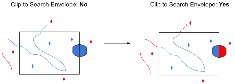
Select this parameter to remove any portions of imported features being read that are outside the Search Envelope.
The illustration below shows the results of the Search Envelope when Clip to Search Envelope is set to No on the left side and Yes on the right side.
- No: Any features that cross the search envelope boundary will be read, including the portion that lies outside of the boundary.
- Yes: Any features that cross the search envelope boundary will be clipped at the boundary, and only the portion that lies inside the boundary will be read. The underlying function for the Clip to Search Envelope function is an intersection; however, when Clip to Search Envelope is set to Yes, a clipping operation is also performed in addition to the intersection.
