Licensing options for this format begin with FME Professional Edition.
Overview
Tableau is a business analytics and data visualization tool with optional online components for displaying visualizations in web pages.
FME provides write access to Tableau Data Extract (.tde) files (also known as extracts). The base name of the TDE file will match the feature type name. Each TDE file will have a single table named Extract present within the file that matches the attribute names and types supplied on the writer feature type properties.
A Tableau Data Extract file is a compressed, memory-mapped file that uses columnar store and supports standard, non-spatial data types as well as certain spatial geometry types. It can be used with Tableau products including Tableau Desktop and Tableau Server.
Each vertex in a piece of geometry must be stored in a separate table row. Because of this, a single feature in FME may be represented in a TDE file with many rows, depending on the size and complexity of the geometry. WGS84 is the required coordinate system for TDE, but FME will reproject features if necessary.
Each attribute in FME is mapped to a column in a TDE file, and spatial information is put into additional columns during the writing process. Each feature type in FME is written to a separate TDE file.
More information about Tableau and TDE files can be found at www.tableau.com.
Versions
This writer supports creation of Tableau 9.1-9.2 TDE files.
About the Writer (TDE)
The TDE writer writes features as rows into a single table in an extract file per feature type in FME. The writer provides the capability to create a single file and table with an arbitrary number of rows and columns. The feature type name will be the name of the TDE file created.
Format Usage Notes
- At the time of writing, Tableau does not support certain complex geometry types, such as polygons with several holes cut out (i.e., complex donut shapes). As a result, certain features may be rendered incorrectly.
- Currently Tableau supports points, lines, arcs (as lines), polygons, ellipses (as polygons), and certain donuts (as polygons). Certain aggregate types such as multipolygons will be drawn, but may be rendered incorrectly.
- Aggregates containing multiple types of geometry such as lines and polygons in one feature will not be rendered correctly in most cases and so will be dropped by the writer.
- Usually, only a single type of geometry (points, lines, or polygons) can be displayed at a time in Tableau:
- If more than one type is present in the same file – polygons and lines, for example – the Marks type in Tableau will draw all geometry the same way. In this case, lines will be closed off between their end point and start point to create polygons. The lines will appear incorrect, but the polygons will appear correct.
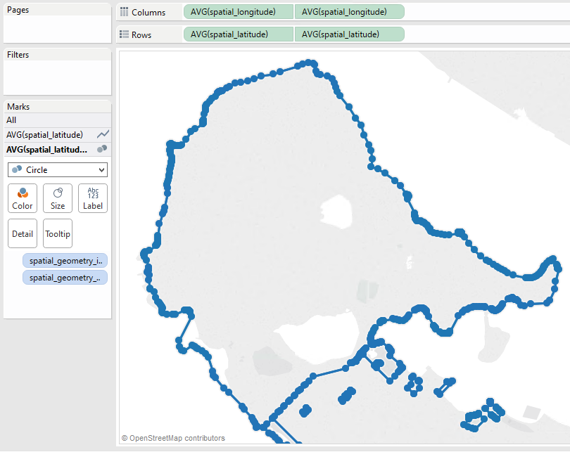
- One workaround is to use the Dual Axis feature and select different Mark types for the different geometry types, but this is limited to two types. Since the same fields are used for the latitude and longitude of the vertices, any shape that can be represented with a simpler type (for example, a line drawn as dots, or a polygon drawn as the perimeter line with no fill) may be drawn multiple times with each selected Mark type. In this example, a polygon is being drawn using the Line and Circle marks. This causes the perimeter of the polygon to be displayed as well as a circle at each vertex.

It may be possible to avoid this by adding an additional column to the table to store the geometry type, creating a Calculated Field for each type that filters to keep only the coordinates for the selected type, and using one set of calculated fields for each axis. However, since the map view allows a maximum of 2 measures, and splitting the latitude and longitude into two sets creates 4 measures, it may not be possible to see the features together on one map.
- A numeric or date attribute with an empty value will cause the feature to be rejected. If these features containing null values should be written to the TDE file, use the NullAttributeMapper in your workspace to set a meaningful default value for these attributes
Writer Overview
The TDE writer uses the Tableau SDK to create TDE files and add rows to them. The TDE writer provides the following capabilities:
When the first feature of each feature type is processed, a TDE file will be created or an existing one will be opened, and the table definition will be constructed.
If the Table Handling Format Parameter for a feature type is set to Create If Needed, the TDE file will be created. If one already exists of the same name, it will be appended to.
If the Table Handling Format Parameter for a feature type is set to Use Existing, then the writer will append features to the TDE file with the same base name as the feature type. If this file does not exist, translation will fail. Due to a limitation of the Tableau SDK, existing TDE files cannot be read to determine the feature IDs in use. As a result, geometry appended to an existing TDE file containing geometry will not use unique feature IDs. For this reason, appending geometry to an existing TDE file is not supported.
If the Table Handling Format Parameter for a feature type is set to Drop and Create, then the writer will drop and recreate the table before writing any features to it.
Tips for Using the Tableau Data Extract (TDE) Writer
When inserting a feature into TDE, missing and null attributes on the feature will be written out as null values. Empty string attributes on the feature will be written out as empty strings.
Troubleshooting
● Before trying to write to the TDE file, ensure that the file is not open.