FME Transformers: 2026.2
Related Transformers
AttributeReprojector
CommonLocalReprojector
CsmapAttributeReprojector
CsmapReprojector
GridInQuestIIReprojector
GtransAttributeReprojector
GtransReprojector
PROJAttributeReprojector
PROJReprojector
ReframeReprojector
ReprojectAngleCalculator
ReprojectLengthCalculator
Reprojector
Reprojects feature coordinates from one coordinate system to another using the Esri reprojection engine.
Typical Uses
- Reprojecting features when explicitly using the Esri reprojection engine is desired.
How does it work?
The EsriReprojector receives features and reprojects their coordinates from one coordinate system to another, using Esri coordinate system definitions and the Esri reprojection engine.
It is not necessary to have Esri products installed to use it.
Both a Source and Destination Coordinate System must be specified, and any coordinate system previously set on the input features will be ignored. Coordinate systems may be selected from a list of available choices, or provided in an attribute value or user parameter. Values must be in the form ESRIWKT|<name>|<esriwkt> where <name> is the coordinate system name, and <esriwkt> is the WKT (Well-Known Text) representing the coordinate system.
If the selected pair of coordinate systems has appropriate Geographic Transformations available, they will be provided.
Geographic Transformation
Both predefined and custom geographic transformations are supported.
Predefined Esri coordinate systems and geographic transformations may be found here.
Geographic transformation names are case-sensitive.
Note Some geographic transformations require transformation grid files that may not be present in ArcGIS or FME by default. If such a transformation is chosen and the grid file is missing, an error will occur. A number of grid files are available in the Reprojection Grid Files download at FME Downloads. Grid files should be placed in the appropriate subfolder in FME\Reproject\EsriPEGridData\.
You can also enter GEOGTRAN Well Known Text that represents a geographic transformation.
Custom transformation files (*.gtf files) can be stored in a number of locations that the EsriReprojector will search for.
All platforms, including without Esri products installed:
<FME_HOME>\Reproject\EsriPEGridData\customTransformation
With Esri products installed:
On Windows systems, additional folders inside the users %appdata% folder will also be searched.
These folders are used by relevant ArcGIS products. If you create a custom transformation inside one of the supported ArcGIS products, the *.GTF file will be stored in the related folder inside %appdata%.
Supported products include ArcGIS Pro, Desktop 10.2 → 10.8.
Full list of %appdata% directories:
%appdata%\Esri\ArcGISPro\ArcToolbox\CustomTransformations
%appdata%\Esri\Desktop10.8\ArcToolbox\CustomTransformation
%appdata%\Esri\Desktop10.7\ArcToolbox\CustomTransformations
%appdata%\Esri\Desktop10.6\ArcToolbox\CustomTransformations
%appdata%\Esri\Desktop10.5\ArcToolbox\CustomTransformations
%appdata%\Esri\Desktop10.4\ArcToolbox\CustomTransformations
%appdata%\Esri\Desktop10.3\ArcToolbox\CustomTransformations
%appdata%\Esri\Desktop10.2\ArcToolbox\CustomTransformations
Rasters
Additional parameters are available for raster features, specifying how the reprojected cells are to be interpolated.
This transformer is not affected by raster band and palette selection.
Vertical and Time-Dependent Transformations
Optional parameters for handling time-based (epoch) and vertical transformations are also available.
When using Epoch, only inter-frame transformations are available, where the input and output features have different coordinate systems but the same epoch.
Examples
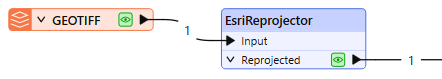
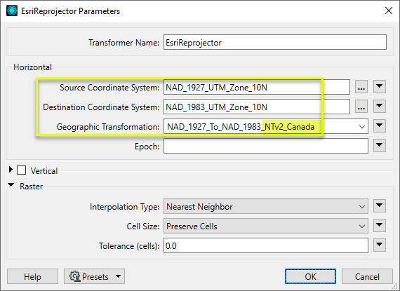
In this example, we have a scanned topo map, georeferenced to UTM zone 10, NAD 27. We want to reproject it to NAD 83.
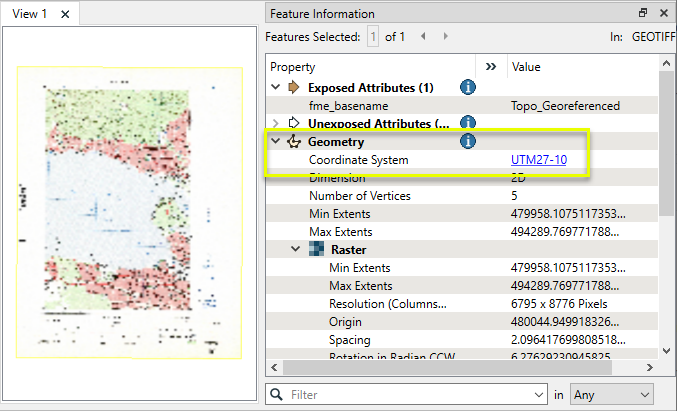
The raster is routed into an EsriReprojector.
In the parameters dialog, appropriate source and destination coordinate systems are selected. Note that this combination of source and destination has several possible Geographic Transformation choices. As the topo is located in Canada, we select the NTv2 Canada option.
Raster settings are left as default.
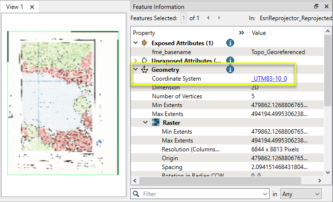
The output raster has been reprojected.
Usage Notes
- FME also has a Workspace Parameter, Reprojection Engine, that may be set to either FME (CS-Map) or Esri. Using this transformer will override this parameter setting.
- To transform between different epochs, consider using the PROJReprojector.
Working With Coordinate System Transformers
FME inherently supports coordinate system transformations and reprojections.
Coordinate systems generally have a name and a definition, and the syntax of that definition can vary greatly between both spatial data formats and other coordinate system libraries. Custom and local coordinate systems can also be defined in FME, further complicating matters. For in-depth information, see the Working With Coordinate Systems documentation.
Reprojections are generally done with the FME Reprojection Engine, which is based on the CS-Map coordinate system library. This default can be overridden on a per-workspace basis, using the Workspace Parameters > Spatial > Reprojection Engine parameter, and set to Esri. Where appropriate, FME will use the Esri Reprojection Engine if it is selected there, with or without an Esri product being installed.
Coordinate System Support
These transformers perform various coordinate system-related tasks, but do not reproject the data.
|
Looks up coordinate system names and definitions between FME’s internal format and common third-party and open source representations, storing the results as an attribute. |
|
|
Retrieves the name of the feature's assigned FME coordinate system into an attribute. |
|
|
Removes the coordinate system from features, without modifying geometry or coordinates. |
|
|
Assigns a specified coordinate system to features, without modifying geometry or coordinates. |
|
|
Assigns a specified local coordinate system to features, without modifying geometry or coordinates. |
Coordinate System Reprojection
Different coordinate system libraries (engines) not only contain coordinate system definitions, they also have unique reprojection algorithms. FME’s generic reprojection transformers, in the first table below, default to using the FME (CS-Map) library.
A selection of other libraries is also available, some of which are specific to certain areas of the world or software platforms.
Inherent reprojections, as in a workspace with different input and output coordinate systems selected, default to using the FME (CS-Map) library.
If you are reprojecting explicitly with a transformer in the workspace, using library-specific transformers is recommended. In the case of CsmapReprojector versus the Reprojector (with default engine), the library may be identical, but the CSMapReprojector handles vertical coordinate calculations whereas the Reprojector does not.
Generic Reprojection Transformers
|
|
|
Library |
|---|---|---|
|
Reprojects x and y coordinates stored as attributes from one coordinate system to another. |
FME (default) or Esri |
|
|
Reprojects one or more features to a local coordinate system centered on the bounding box containing all features. |
FME (default) or Esri |
|
|
Converts a given angle from one coordinate system to another. |
FME (default) or Esri |
|
|
Converts a given length from one coordinate system to another. |
FME (default) or Esri |
|
|
Reprojects feature x and y coordinates from one coordinate system to another. |
FME (default) or Esri |
Library-Specific Reprojection Transformers (Recommended)
|
|
|
Library (External Links) |
|---|---|---|
|
Reprojects x, y, and optionally z coordinates stored as attributes from one coordinate system to another using the CS-MAP library. |
||
|
Reprojects feature x, y, and optionally z coordinates from one coordinate system to another using the CS-Map library. |
||
|
Reprojects feature coordinates from one coordinate system to another using the Esri reprojection library. |
||
|
Great Britain Northern Ireland Republic of Ireland |
Reprojects feature coordinates from one coordinate system to another using the Grid InQuestII engine from Ordnance Survey, for use in Great Britain, Ireland, and Northern Ireland. |
|
|
Sweden |
Reprojects coordinates stored as attributes from one coordinate system to another using the Gtrans reprojection engine from the National Land Survey of Sweden (Lantmäteriet). |
|
|
Sweden |
Reprojects feature coordinates from one coordinate system to another using the Gtrans reprojection engine from the National Land Survey of Sweden (Lantmäteriet). |
|
|
Reprojects coordinates stored as attributes from one coordinate system to another using the PROJ library. |
||
|
Reprojects feature coordinates from one coordinate system to another using the PROJ library. |
||
|
Switzerland |
Reprojects feature coordinates from one coordinate system to another in Switzerland, using the Reframe library from the Federal Office of Topography (swisstopo). |
Configuration
Input Ports
This transformer accepts any feature.
Output Ports
Features reprojected as specified in parameters.
Features that could not be reprojected are output here.
Rejected features will have an fme_rejection_code attribute with one of the following values:
INVALID_SOURCE_COORDINATE_SYSTEM
INVALID_DESTINATION_COORDINATE_SYSTEM
MISSING_GRID_FILE
INVALID_GEOGRAPHIC_TRANSFORMATION
INVALID_REPROJECTION_INPUT_COORDINATES
MISSING_EPOCH
INVALID_EPOCH
INVALID_VERTICAL_TRANSFORMATION
INVALID_PARAMETER_TOLERANCE
Rejected Feature Handling: can be set to either terminate the translation or continue running when it encounters a rejected feature. This setting is available both as a default FME option and as a workspace parameter.
Parameters
|
Geometry Selection |
Select the geometry to be reprojected. The selectable options will reflect the geometries available from the input features. If input features contain nameless geometries, <geometry> is also available:
|
|
Source Coordinate System |
Select the coordinate system of the incoming features. Available Esri coordinate systems can be accessed via the ellipsis button, where coordinate systems may also be imported. The coordinate system may also be provided as Esri WKT via an attribute or user parameter. Values must be in the form ESRIWKT|<name>|<esriwkt> where <name> is the coordinate system name, and <esriwkt> is the WKT (Well-Known Text) representing the coordinate system. The coordinate system selected here will override any coordinate system already attached to the features. |
|
Destination Coordinate System |
Select the coordinate system to be reprojected to. Available Esri coordinate systems can be accessed via the ellipsis button, where coordinate systems may also be imported. The coordinate system may also be provided as Esri WKT via an attribute or user parameter. Values must be in the form ESRIWKT|<name>|<esriwkt> where <name> is the coordinate system name, and <esriwkt> is the WKT (Well-Known Text) representing the coordinate system. |
|
Geographic Transformation |
A selection of available geographic transformations is provided once a Source and Destination Coordinate System are set. |
|
Epoch |
(Optional) A decimal year value representing the time dimension to be used, for time-dependent geographic transformations. The value may also be an ISO or FME formatted datetime. If the Geographic Transformation provided is time-dependent, and no Epoch is supplied, then the translation will fail. If the Geographic Transformation provided is not time-dependent, and an Epoch is supplied, then the Epoch will be ignored and the translation will continue. Note Only inter-frame transformations are available at this time - that is, both the input and output features will have the same epoch.
|
|
Vertical Handling |
Select a method for transforming height values on incoming features:
|
|
Source Vertical Coordinate System |
Select the vertical coordinate system of the incoming features. Available Esri vertical coordinate systems can be accessed via the ellipsis button, where vertical coordinate systems may also be imported. The vertical coordinate system may also be provided as Esri WKT. |
|
Destination Vertical Coordinate System |
Select the vertical coordinate system to be reprojected to. Available Esri vertical coordinate systems can be accessed via the ellipsis button, where vertical coordinate systems may also be imported. The vertical coordinate system may also be provided as Esri WKT. |
|
Vertical Transformation |
A selection of available vertical transformations is provided once a Source and Destination Vertical Coordinate System are set. The vertical transformation may also be provided as Esri WKT. |
|
Interpolation Type |
Select a method for interpolating reprojected cell values:
|
||||||||||
|
Cell Size |
Select a method for resizing cells:
|
||||||||||
|
Tolerance (cells) |
Sets the tolerance, in cells, for approximating reprojected cell locations. Using the default value of 0.0, every cell will be reprojected. If a value greater than 0.0 is specified, some cell locations will be approximated. The difference between an approximated cell location and the true cell location should be at most the tolerance value. For example, if a value of 0.5 is specified, each approximated cell location should be maximum one-half of a pixel away from its true location. Increasing the Tolerance value may improve performance. |
Editing Transformer Parameters
Transformer parameters can be set by directly entering values, using expressions, or referencing other elements in the workspace such as attribute values or user parameters. Various editors and context menus are available to assist. To see what is available, click  beside the applicable parameter.
Defining Values
There are several ways to define a value for use in a Transformer. The simplest is to simply type in a value or string, which can include functions of various types such as attribute references, math and string functions, and workspace parameters.
Using the Text Editor
The Text Editor provides a convenient way to construct text strings (including regular expressions) from various data sources, such as attributes, parameters, and constants, where the result is used directly inside a parameter.
Using the Arithmetic Editor
The Arithmetic Editor provides a convenient way to construct math expressions from various data sources, such as attributes, parameters, and feature functions, where the result is used directly inside a parameter.
Conditional Values
Set values depending on one or more test conditions that either pass or fail.
Parameter Condition Definition Dialog
Content
Expressions and strings can include a number of functions, characters, parameters, and more.
When setting values - whether entered directly in a parameter or constructed using one of the editors - strings and expressions containing String, Math, Date/Time or FME Feature Functions will have those functions evaluated. Therefore, the names of these functions (in the form @<function_name>) should not be used as literal string values.
| These functions manipulate and format strings. | |
|
Special Characters |
A set of control characters is available in the Text Editor. |
| Math functions are available in both editors. | |
| Date/Time Functions | Date and time functions are available in the Text Editor. |
| These operators are available in the Arithmetic Editor. | |
| These return primarily feature-specific values. | |
| FME and workspace-specific parameters may be used. | |
| Creating and Modifying User Parameters | Create your own editable parameters. |
Table Tools
Transformers with table-style parameters have additional tools for populating and manipulating values.
|
Row Reordering
|
Enabled once you have clicked on a row item. Choices include:
|
|
Cut, Copy, and Paste
|
Enabled once you have clicked on a row item. Choices include:
Cut, copy, and paste may be used within a transformer, or between transformers. |
|
Filter
|
Start typing a string, and the matrix will only display rows matching those characters. Searches all columns. This only affects the display of attributes within the transformer - it does not alter which attributes are output. |
|
Import
|
Import populates the table with a set of new attributes read from a dataset. Specific application varies between transformers. |
|
Reset/Refresh
|
Generally resets the table to its initial state, and may provide additional options to remove invalid entries. Behavior varies between transformers. |


Note: Not all tools are available in all transformers.
For more information, see Transformer Parameter Menu Options.
Reference
|
Processing Behavior |
|
|
Feature Holding |
No |
| Dependencies | None |
| Aliases | |
| History |
FME Online Resources
The FME Community and Support Center Knowledge Base have a wealth of information, including active forums with 35,000+ members and thousands of articles.
Search for all results about the EsriReprojector on the FME Community.
Examples may contain information licensed under the Open Government Licence – Vancouver, Open Government Licence - British Columbia, and/or Open Government Licence – Canada.