Feature Types
These parameters are used only when generating an initial workspace, so they are not editable within FME Workbench after the workspace has been generated.
You can choose either OSM Map Features (default), or Basic Element Feature Types Only. This selection determines whether OSM Map Feature parameters below are enabled or disabled.
This parameter allows you to add a custom map features configuration file to define features or modify/remove existing features.
Any changes to the map features made here will be reflected in the map features tree view below. Please refer to OpenStreetMap (OSM) XML User Configuration File Guidelines for information on how to write your own config file.
Map Features Config File
This parameter specifies the file that is used to control how OSM PBF files are interpreted. Undefined behavior may occur if this parameter is changed after an OSM PBF has been generated.
OSM Map Features
These parameters are used only when generating an initial workspace, so they are not editable within FME Workbench after the workspace has been generated.
Click the browse button to open a tree view that displays all the map features listed in the wiki at http://wiki.openstreetmap.org/wiki/Map_Features. Additionally, any added/removed features specified in the user config file will take effect here.
Expanding the root osm element in the list displays the items defined as broad features (keys) by the wiki. Expanding any broad feature shows its specific features (values). In this example, building, geological, and natural are the broad features. Specific features are prefixed by the broad feature's name:
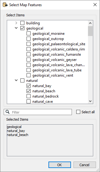
Note that if a specific feature contains attributes or geometry types that its broad feature does not, the broad feature will include these items even if it is selected and the specific feature is not. For example, if highway_primary includes an attribute width but highway does not include the attribute, highway must represent highway_primary and include width in its schema feature.
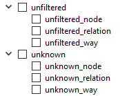
The list also includes unfiltered and unknown feature types. When the OSM reader reads the dataset, any elements that have map features defined in the wiki or user configuration file are emitted as unfiltered features if they were not selected in this list. Any elements that do not contain any defined map features will be emitted as unknown. In the list, unknown and unfiltered can also be expanded into respective nodes, ways, and relations. This will further filter unknown and unfiltered elements into their primitive categories.
Some OSM elements can contain multiple map feature tags.
- If the Use First option is selected, the first map feature tag will be constructed as a feature. This option will not check for alternative map features.
- If the Use First and List Alternatives option is selected, the first map feature tag will be constructed as a feature, while the other map features are set as a list attribute called alternative_map_features.
- If the Duplicate Features option is selected, a feature will be constructed for each map feature tag. For example, an OSM element has 1 aerialway tag, 1 barrier tag, and 1 craft tag. Three nearly identical features will be created for this element – the difference is that the feature type names will be aerialway, barrier, and craft, respectively.
This parameter determines which attributes should be included in OSM feature type schemas.
OSM feature types are indicated by the presence of certain feature-type-determining tags, and these feature types are associated with a common set of schema attributes. Additionally, there is a set of schema attributes associated with each particular value of the feature-type-determining tag.
- Only Use Tag Key Attributes – Only include schema attributes that are associated with all features of a feature type.
- Merge With Tag Value Attributes – In addition to attributes associated with all features of a feature type, also include schema attributes that are associated with each particular value of the feature-type-determining tag. Note that this option does not affect which tags will exist on OSM features – it only affects which attributes are exposed on the reader schema.
Advanced
This parameter specifies the maximum size of the in-memory temporary database that is used to process elements that reference other elements’ geometry. After this size is reached, the temporary database will be written to disk.
If not specified, a default value will be used.
The parameter controls whether or not to use a faster, but more failure-prone, method of indexing nodes during processing.
The faster method can fail if node IDs are non-increasing, or if node IDs are particularly large in value. In these cases, the translation will fail and an error message will recommend that this parameter be set to No.
By default, this parameter is set to Yes.
Schema Attributes
Additional Attributes to Expose
Use this parameter to expose Format Attributes in FME Workbench when you create a workspace:
- In a dynamic scenario, it means these attributes can be passed to the output dataset at runtime.
- In a non-dynamic scenario, this parameter allows you to expose additional attributes on multiple feature types. Click the browse button to view the available format attributes (which are different for each format) for the reader.
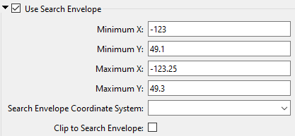
Use Search Envelope
|
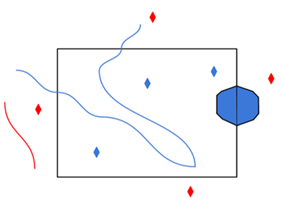
A search envelope (also known as a bounding box) is a rectangular area that defines a geographic area. In FME, the easiest way to define a search envelope is to use search envelope parameters. Defining a search envelope is the most efficient method of selecting an area of interest because FME will read only the data that is necessary – it does not have to read an entire dataset. Search Envelope parameters apply to both vector and raster datasets and can be particularly efficient if the source format has a spatial index. Most FME readers have parameters to define the search envelope of data that is being read:
The parameters include the x and y coordinates of the bounding box as well as a parameter that defines the coordinate system. How to Define the Bounding Box Using the minimum and maximum x and y parameters, define a bounding box that will be used to filter the input features. Only features that intersect with the bounding box are returned. Note that the bounding box intersection is not a full geometry intersection (based on spatial relationships) that would be returned by a transformer like the SpatialFilter. Note If all four coordinates of the search envelope are left at 0, the search envelope will be disabled even if this option is checked.
|
|||||||
|
Search Envelope Coordinate System |
Specifies the coordinate system of the search envelope if it is different than the coordinate system of the data. The coordinate system associated with the data to be read must always be set if this parameter is set. If this parameter is set, the minimum and maximum points of the search envelope are reprojected from the Search Envelope Coordinate System to the reader’s coordinate system prior to applying the envelope. |
||||||
|
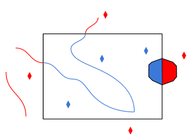
Clip to Search Envelope |
The underlying function for Use Search Envelope is an intersection; however, when Clip to Search Envelope is checked, a clipping operation is also performed.
|
||||||