Dataset Parameters
Zoom Level
Specifies the zoom level that will be used when reading the MBTiles MVT file. A value of Maximum will read the zoom level stored in the metadata table as maxzoom.
If maxzoom does not exist in the metadata table, then most resolute zoom level that has at least one tile in the tiles table will be read.
Spatial Filter
This parameter contains the following options:
- Source Data Bounds – The Bounds metadata item is read from the MBTiles file and used as the spatial filter.
- Search Envelope – Enables the Use Search Envelope parameter. The minimum and maximum x and y parameters define a Spatial Filter for the input features. You can also specify a coordinate system that applies to the values in the box. The x and y values are initially set to EPSG:3857 Spherical Mercator.
- None – No spatial filter will be used.
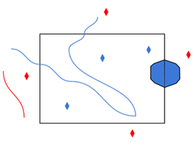
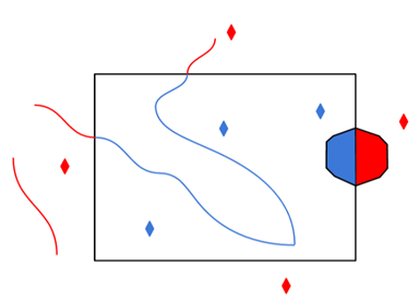
Only features that intersect with the Spatial Filter are returned.
Clip Geometries to Tile Extents
Generators of vector tiles will typically create geometries with a small buffer beyond the tile extent so that geometries intersecting several tiles can be unioned back.
This option allows clipping of the geometries of input vector features to the tile extent.
The default is Yes – Any buffer geometries are removed and geometries are clipped to the tile extent.
Apply MVT Metadata
The reader will use vector_layers metadata to define feature types, but also temporarily serialize JSON metadata when reading MVT data. Enabling this option will parse complete metadata at the cost of additional processing time.
The default is No – Avoid reading the default metadata.json.
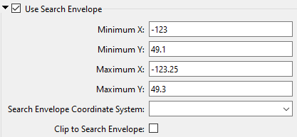
Use Search Envelope
|
A search envelope (also known as a bounding box) is a rectangular area that defines a geographic area. In FME, the easiest way to define a search envelope is to use search envelope parameters. Defining a search envelope is the most efficient method of selecting an area of interest because FME will read only the data that is necessary – it does not have to read an entire dataset. Search Envelope parameters apply to both vector and raster datasets and can be particularly efficient if the source format has a spatial index. Most FME readers have parameters to define the search envelope of data that is being read:
The parameters include the x and y coordinates of the bounding box as well as a parameter that defines the coordinate system. How to Define the Bounding Box Using the minimum and maximum x and y parameters, define a bounding box that will be used to filter the input features. Only features that intersect with the bounding box are returned. Note that the bounding box intersection is not a full geometry intersection (based on spatial relationships) that would be returned by a transformer like the SpatialFilter. Note If all four coordinates of the search envelope are left at 0, the search envelope will be disabled even if this option is checked.
|
|||||||
|
Search Envelope Coordinate System |
Specifies the coordinate system of the search envelope if it is different than the coordinate system of the data. The coordinate system associated with the data to be read must always be set if this parameter is set. If this parameter is set, the minimum and maximum points of the search envelope are reprojected from the Search Envelope Coordinate System to the reader’s coordinate system prior to applying the envelope. |
||||||
|
Clip to Search Envelope |
The underlying function for Use Search Envelope is an intersection; however, when Clip to Search Envelope is checked, a clipping operation is also performed.
|
||||||

Schema Attributes
Additional Attributes to Expose
Use this parameter to expose Format Attributes in FME Workbench when you create a workspace:
- In a dynamic scenario, it means these attributes can be passed to the output dataset at runtime.
- In a non-dynamic scenario, this parameter allows you to expose additional attributes on multiple feature types. Click the browse button to view the available format attributes (which are different for each format) for the reader.