Specification Variant
This indicates which GDF specification will be used when creating the output GDF file. Several GDF data producers do not strictly follow the official CEN GDF 3.0 standard, but rather follow their own slightly modified version of these standards. If you know the specification your file uses, you can indicate it here. If not, FME will use Best Guess to determine the specification.
Tells the GDF reader to use an intelligent guess as to which specification to use, based on the header of the GDF file it is overwriting, if any.
The official CEN 3.0 specification is used.
The NavTech variant of the GDF specification is used.
The TeleAtlas variant of the GDF specification is used.
Geometry Completion
Indicates the level up to which the user wants to complete the geometry. All levels above this will have the geometry linked to the features indirectly. All levels with complete geometry will have the geometry explicitly on each feature directly.
When FME reads GDF files, it requires a lot of resources to store and reference all the features between layers. For example, to get the geometry of a single level 2 feature, FME must do the following:
- Locate all the level 1 features that are linked to it.
- Locate all the level 0 features that are linked to each Level 1 feature.
- Locate all the XYZ features that are linked to every Level 0 feature.
- Combine all the geometry and process it to generate the geometry for the single level 2 feature. It is much easier if the features were output with no geometry but instead kept attributes that indicated to which other features it was linked.
For this reason, there is an option of choosing whether features produced by the reader contain the links, or if FME should complete the links and form the geometry on each feature. There is also the option of specifying on which levels the geometry should be completed, and which levels will be left as "linked" to lower-level features.
Usage Example 1: Level 1
If you were only interested in the level 1 features of a GDF dataset (you were going to delete or ignore the level 2 features), then there would be no reason for FME to complete the geometry on level 2 features. You could choose to complete only the geometry on level 1 features and leave the level 2 features as linked (since you would be deleting them anyway).
Usage Example 2: None
You are planning to import features into a spatial database. In your new model, you would like to keep the links present so that if you edited and modified the geometry of a level 0 feature, the geometry of all level 1 and 2 features that link to it would immediately change. In this situation, you would select None for geometry completion, and just import all the features into your database as linked.
Usage Example 3: Level 2
If you are translating GDF to any of the more common file-based formats for general viewing and usage, completing the geometry all the way up to level 2 is probably the most reasonable choice, since it determines if geometry links are resolved to build geometry on higher level features.
Attributes
Indicates whether to complete the attribute links for each feature.
- If checked, all features will have their attributes explicitly appear on the features directly.
- If unchecked, all features will have their attribute information remain in separate tables joined with link values.
The issues surrounding attribute completion when reading GDF is similar to geometry completion. Natively, a feature’s attributes are referenced through a linking mechanism and extra effort is needed if it is desired that the features read from GDF know all their attributes directly.
Therefore there is an option of choosing between whether features produced by the reader have the "links" on them or if FME should spend the resources to complete the links and supply the attributes directly on each feature as they are read. Reasoning as to whether or not to choose attribute completion is similar to that outlined for geometry completion.
Indicates whether attribute features that have been used in attribute completion are output by the reader.
If this option is checked, then features that primarily carry attribute values (for example, GDF Name records) will be output.
Code
Indicates whether known codes of attribute names are replaced with their actual expanded name for each feature. If this option is checked, all features will have the code values of their attribute names replaced. For example, an attribute ON will be renamed to Official Name.
If this option is not checked, all features will have their attribute names left as the original codes.
Indicates whether known codes of attributes are replaced with their actual expanded values for each feature. If this option is checked, all features will have the code values of their attributes replaced. For example, an attribute Vehicle Type with the value 16 will have that value replaced by Taxi.
If this option is not checked, all features will have their attribute values left as the original codes.
Metadata Options
Indicates whether the reader should to ignore the FIELDEFREC (03) and RECDEFREC (04) records in the GDF file, or parse and honor them.
If you check this option, all FIELDEFREC (03) and RECDEFREC (04) records in the file will be ignored when reading. This is useful for reading files with corrupt metadata. Without ignoring these corrupt lines, the file cannot be read correctly.
Multiple Value Separator
Specifies the characters that will separate values when an attribute has more than one value.
The multiple value separator can be any string.
For example, the Name attribute of a Country may have two values: Japan and Nippon. If the three-colon (:::) separator is specified, the value for Name will be Japan:::Nippon.
Schema Attributes
Use this parameter to expose Format Attributes in FME Workbench when you create a workspace:
- In a dynamic scenario, it means these attributes can be passed to the output dataset at runtime.
- In a non-dynamic scenario, this parameter allows you to expose additional attributes on multiple feature types. Click the browse button to view the available format attributes (which are different for each format) for the reader.
Spatial
Coordinate systems may be extracted from input feature data sources, may come predefined with FME, or may be user-defined. FME allows different output and input coordinate systems, and performs the required coordinate conversions when necessary.
If a coordinate system is specified in both the source format and the workspace, the coordinate system in the workspace is used. The coordinate system specified in the source format is not used, and a warning is logged. If a source coordinate system is not specified in the workspace and the format or system does not store coordinate system information, then the coordinate system is not set for the features that are read.
If a destination coordinate system is set and the feature has been tagged with a coordinate system, then a coordinate system conversion is performed to put the feature into the destination system. This happens right before the feature enters into the writer.
If the destination coordinate system was not set, then the features are written out in their original coordinate system.
If a destination coordinate system is set, but the source coordinate system was not specified in the workspace or stored in the source format, then no conversion is performed. The features are simply tagged with the output system name before being written to the output dataset.
For systems that know their coordinate system, the Coordinate System field will display Read from Source and FME will read the coordinate system from the source dataset. For most other input sources, the field will display Unknown (which simply means that FME will use default values). In most cases, the default value is all you'll need to perform the translation.
You can always choose to override the defaults and choose a new coordinate system. Select More Coordinate Systems from the drop-down menu to open the Coordinate System Gallery.
Changing a Reprojection
To perform a reprojection, FME typically uses the CS-MAP reprojection engine, which includes definitions for thousands of coordinate systems, with a large variety of projections, datums, ellipsoids, and units. However, GIS applications have slightly different algorithms for reprojecting data between different coordinate systems. To ensure that the data FME writes matches exactly to your existing data, you can use the reprojection engine from a different application.
To change the reprojection engine, Select Workspace Parameters > Spatial > Reprojection Engine. In the example shown, you can select Esri (but the selection here depends on your installed applications):

- The coordinate systems file coordsys.db in the FME installation folder contains the names and descriptions of all predefined coordinate systems.
- Some users may wish to use coordinate systems that do not ship with FME, and in those cases, FME also supports custom coordinate systems.
- Learn more about Working with Coordinate Systems in FME.
A search envelope (also known as a bounding box) is a rectangular area that defines a geographic area. In FME, the easiest way to define a search envelope is to use search envelope parameters.
Defining a search envelope is the most efficient method of selecting an area of interest because FME will read only the data that is necessary – it does not have to read an entire dataset. Search Envelope parameters apply to both vector and raster datasets and can be particularly efficient if the source format has a spatial index.
Most FME readers have parameters to define the search envelope of data that is being read:
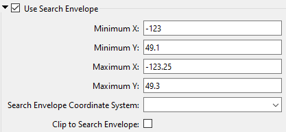
The parameters include the x and y coordinates of the bounding box as well as a parameter that defines the coordinate system.
How to Define the Bounding Box
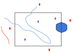
Using the minimum and maximum x and y parameters, define a bounding box that will be used to filter the input features. Only features that intersect with the bounding box are returned. Note that the bounding box intersection is not a full geometry intersection (based on spatial relationships) that would be returned by a transformer like the SpatialFilter.
|
Search Envelope Coordinate System |
Specifies the coordinate system of the search envelope if it is different than the coordinate system of the data. The coordinate system associated with the data to be read must always be set if this parameter is set. If this parameter is set, the minimum and maximum points of the search envelope are reprojected from the Search Envelope Coordinate System to the reader’s coordinate system prior to applying the envelope. |
||||||
|
Clip to Search Envelope |
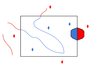
The underlying function for Use Search Envelope is an intersection; however, when Clip to Search Envelope is checked, a clipping operation is also performed.
|

Advanced
FME supports several versions of the TeleAtlas product. If you leave this value as Best Guess, FME will attempt to read the version from the header of the file.
If specified, this value overrides the file version value. This is useful in the case where the header is incorrect for the data in the GDF file.