Feature Properties
This parameter specifies whether the GML geometric properties should be represented as attributes in the FME feature type definitions.
In FME data features, the GML geometric properties are represented as a single named geometry – or, if multiple geometries are present, as an aggregate geometry with multiple named geometry components. The name and the position for these geometric elements can also be controlled through the OGC GML User Attributes
- If this parameter is checked (which is the default), then the feature type definitions will contain the geometry names as attributes, and their type is set to xml_geometry. If an attribute X has its type set to xml_geometry, this attribute X becomes a placeholder in the feature type definition. It is a placeholder because actual data features for the feature type definitions will not have this attribute; instead, the data features will have a geometry named “X”.
- If this parameter is unchecked, then the feature type definition will not contain geometry names.
The list of whitespace-separated QNames specified in this parameter defines properties that the reader should ignore while processing the GML application schemas.
To ignore property regardless of namespace, simply specify the local-part of the name. For example:
boundedBy name
will ignore all properties whose local name are boundedBy or name, regardless of their namespace.
A prefix in a QName should be present in the parsed XML schemas. If no corresponding URI namespace can be found for a prefix, then the prefix will be discarded. The QName will (as in the unprefixed case) apply to all properties with the same local-part, regardless of namespace.
For example:
gml:boundedBy identifier wrong-prefix:description
If a binding for the gml prefix can be found in the parsed schema, then only boundedBy properties with the same namespace URI as gml will be ignored; otherwise, every boundedBy property regardless of namespace will be ignored.
Every identifier property, regardless of namespace, will be ignored. Every description property regardless of namespace will also be ignored, since the parsed schema will not have a binding for the "wrong-prefix" prefix.
Use this parameter to expose Format Attributes in FME Workbench when you create a workspace:
- In a dynamic scenario, it means these attributes can be passed to the output dataset at runtime.
- In a non-dynamic scenario, this parameter allows you to expose additional attributes on multiple feature types. Click the browse button to view the available format attributes (which are different for each format) for the reader.
|
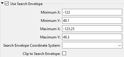
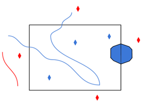
A search envelope (also known as a bounding box) is a rectangular area that defines a geographic area. In FME, the easiest way to define a search envelope is to use search envelope parameters. Defining a search envelope is the most efficient method of selecting an area of interest because FME will read only the data that is necessary – it does not have to read an entire dataset. Search Envelope parameters apply to both vector and raster datasets and can be particularly efficient if the source format has a spatial index. Most FME readers have parameters to define the search envelope of data that is being read:
The parameters include the x and y coordinates of the bounding box as well as a parameter that defines the coordinate system. How to Define the Bounding Box Using the minimum and maximum x and y parameters, define a bounding box that will be used to filter the input features. Only features that intersect with the bounding box are returned. Note that the bounding box intersection is not a full geometry intersection (based on spatial relationships) that would be returned by a transformer like the SpatialFilter. Note If all four coordinates of the search envelope are left at 0, the search envelope will be disabled even if this option is checked.
|
|||||||
|
Search Envelope Coordinate System |
Specifies the coordinate system of the search envelope if it is different than the coordinate system of the data. The coordinate system associated with the data to be read must always be set if this parameter is set. If this parameter is set, the minimum and maximum points of the search envelope are reprojected from the Search Envelope Coordinate System to the reader’s coordinate system prior to applying the envelope. |
||||||
|
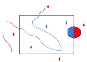
Clip to Search Envelope |
The underlying function for Use Search Envelope is an intersection; however, when Clip to Search Envelope is checked, a clipping operation is also performed.
|
||||||