Readers: For information on the parameters in this dialog that are common to all readers, see:
Writers: For information on the parameters in this dialog that are common to all writers, see:
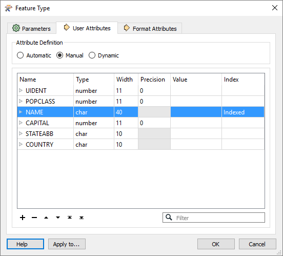
The following table shows the attribute types that are supported.
|
Name |
The name of the shapefile. |
|
Type |
This format supports the following field types. char Character fields store fixed-length strings. When a character field is written, it is right-padded with spaces, or truncated, to fit the width. When a character field is retrieved, any padding space characters are stripped away. Some encodings store a single character, or codepoint, as one or more bytes. For example, in UTF-8, the codepoint Ä is represented by two bytes, so the string Äpple may look 5 characters long but it requires 6 bytes to store. date Temporal (date) field composed of year, month and date; ranging from January 1, 0001, to December 31, 9999. Field size: 4 bytes More information on Standard FME Date/Time Format. double Double fields store 8-byte double precision floating point values. float Float fields store 4-byte single precision floating point values. logical Logical fields store TRUE/FALSE data. Data read to or written from such fields must always have a value of either true or false. long Long fields store 4-byte signed integer values +/- 2147483647. number Number fields store single and double precision floating point values. The decimals parameter controls the precision of the data and is the number of digits to the right of the decimal. Additional digits will be rounded off. short Short fields store 2-byte signed integer values +/- 32767. |
|
Width |
The width parameter controls the maximum characters that can be stored by the field. For the number type, the width parameter is the total number of characters allocated to the field, including the decimal point. |
|
Precision |
For some attribute types, controls the precision of the data and specifies the number of digits to the right of the decimal. |
|
Index |
FME supports index reading for all columns that are flagged as Indexed. Any attribute that is indexed must be maximum 80 characters wide. Attribute names cannot contain characters that are illegal in Windows filenames. |
|
|
Writing Attribute Indexes Note: Writing attribute indexes requires that FME is running on a machine with ArcGIS or ArcPro installed. Additionally, 32-bit FME must be used with ArcGIS and 64-bit FME must be used with Arc Pro in order for attribute indexes to be generated. This feature is not available on non-Windows platforms. The Shapefile writer can index shape data by attribute and produce attribute index files. These files are named as <featureClass>.<attributeName>.atx. FME attempts to index all attributes that are flagged as Indexed in the user attributes tab of the Shapefile Feature Type dialog.
Any attribute of type char or number that is indexed must be maximum 80 characters wide. Additionally, attribute names cannot contain characters that are illegal in Windows filenames. If any attributes are flagged for indexing, FME automatically produces spatial index files for the feature type, regardless of the Write Spatial Index setting in the writer parameters dialog. For more information, see the writer parameter Create Spatial Index. |
