Dataset
The value for this parameter is the path to the DHT file.
The folder in which this file exists is the root folder of the VPF database. This folder directly and indirectly contains all the libraries, coverages, feature classes and related metadata for the database. A typical file path that selects a VMap database from drive e: would be:
e:/vmaplv0/dht
Feature Class Parameters
This parameter is used to limit the available feature classes that are read. If this parameter is not specified, all available feature classes are read.
The value for this parameter is the character that is used in a feature’s feature type to separate the library and coverage names from the metadata table and feature class names. If this attribute is not specified, then the ‘\’ separator is used.
Tile Parameters
Limits the geometric features that are produced. Only feature class features that exist in the specified tiles will be output.
If you do not specify a value, all the tiles in the library (or libraries) will be used.
| How to | Example | |
|---|---|---|
| Specify separate tiles: | tileId0, tileId1,... | |
| Specify a range of tiles: | tileId0-tileIdN | |
| Specify tiles in multiple libraries: |
a1234{2,3} gen13a{5,6} h5678{8,9}
Note that if you have multiple libraries (for example, a1234, gen13a, h5678), and for Tile IDs, you enter: a1234{2,3} gen13a{5,6} then all tiles in the h5678 library will be read, because no filter was provided for that library. |
Note: This parameter is ignored if a tiled subset is specified for a nontiled library.
Tile extents will take a string formed by a comma-separated list of coordinates. The minimum x is followed by the minimum y, and then the maximum x is followed by the maximum y value. For example:
minx,miny,maxy,maxy
where minx,miny represent the lower left corner of the bounding box and maxx,maxy represent the top right corner of the bounding box.
The tiles that will be read are those whose bounds overlap (not just touch) the specified extents. For example, specifying a Tile Extents of 0,0,10,10 will not read a tile with bounds 5,10..6,11. The entirety of each tile will be read, and therefore features may be read that don't fit into the specified Tile Extents.
If there are no tiles that touch the Tile Extents, then all tiles will be read.
Schema Attributes
Use this parameter to expose Format Attributes in Workbench when you create a workspace:
- In a dynamic scenario, it means these attributes can be passed to the output dataset at runtime.
- In a non-dynamic scenario where you have multiple feature types, it is convenient to expose additional attributes using this one parameter. For example, if you have ten feature types and want to expose the same attribute in each one, it is easier to define it once than it is to set each feature type individually in the workspace.
Using the minimum and maximum x and y parameters, define a bounding box that will be used to filter the input features. Only features that intersect with the bounding box are returned.
If all four coordinates of the search envelope are specified as 0, the search envelope will be disabled.
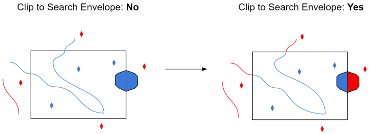
Select this parameter to remove any portions of imported features being read that are outside the Search Envelope.
The illustration below shows the results of the Search Envelope when Clip to Search Envelope is set to No on the left side and Yes on the right side.
- No: Any features that cross the search envelope boundary will be read, including the portion that lies outside of the boundary.
- Yes: Any features that cross the search envelope boundary will be clipped at the boundary, and only the portion that lies inside the boundary will be read. The underlying function for the Clip to Search Envelope function is an intersection; however, when Clip to Search Envelope is set to Yes, a clipping operation is also performed in addition to the intersection.
