|
Database formats include a Database Connection parameter that defines and stores authentication information. For general information about sharing database connections, please see Using Database Connections. Note that Database Connection parameters differ slightly, depending on context and/or database format. |
|
Connection From the Connection parameter in a database format, you can do one of the following:
|
Database Connection
Select the Esri File Geodatabase destination folder.
- When unchecked (default) and a database already exists, then tables and features are written to the existing database.
- When checked, any existing database is deleted before writing begins. Checking this option also enables the Template File parameter.
If a database does not exist when writing begins, a new database is created.
If a template File Geodatabase is specified, the destination File Geodatabase is replaced with a copy of the template before writing begins.
General
This setting defines the writer behavior when a Feature Dataset is provided. There are three options:
- Write Feature Dataset (default) – If a Feature Dataset is specified, it will write it if possible.
- Warn and Ignore Feature Dataset – In this mode, if a Feature Dataset is specified, a warning will be logged and the writer will treat it as if the Feature Dataset was not provided.
- Error and End Translation – In this mode, if a Feature Dataset is specified, an error will be logged and the translation will end.
- Off - Slashes Become Underscores – Forward slashes "/" will be converted to underscores "_".
Case Conversion
These parameters change the case of all feature type and attribute names in the output.
- UPPERCASE – Change all feature type names to uppercase text.
- lowercase – Change all feature type names to lowercase text.
- None – Do not make changes to any feature type names.
- UPPERCASE – Change all attribute names to uppercase text.
- lowercase – Change all attribute names to lowercase text.
- None – Do not make changes to any attribute names.
Spatial
Coordinate systems may be extracted from input feature data sources, may come predefined with FME, or may be user-defined. FME allows different output and input coordinate systems, and performs the required coordinate conversions when necessary.
If a coordinate system is specified in both the source format and the workspace, the coordinate system in the workspace is used. The coordinate system specified in the source format is not used, and a warning is logged. If a source coordinate system is not specified in the workspace and the format or system does not store coordinate system information, then the coordinate system is not set for the features that are read.
If a destination coordinate system is set and the feature has been tagged with a coordinate system, then a coordinate system conversion is performed to put the feature into the destination system. This happens right before the feature enters into the writer.
If the destination coordinate system was not set, then the features are written out in their original coordinate system.
If a destination coordinate system is set, but the source coordinate system was not specified in the workspace or stored in the source format, then no conversion is performed. The features are simply tagged with the output system name before being written to the output dataset.
For systems that know their coordinate system, the Coordinate System field will display Read from Source and FME will read the coordinate system from the source dataset. For most other input sources, the field will display Unknown (which simply means that FME will use default values). In most cases, the default value is all you'll need to perform the translation.
You can always choose to override the defaults and choose a new coordinate system. Select More Coordinate Systems from the drop-down menu to open the Coordinate System Gallery.
Changing a Reprojection
To perform a reprojection, FME typically uses the CS-MAP reprojection engine, which includes definitions for thousands of coordinate systems, with a large variety of projections, datums, ellipsoids, and units. However, GIS applications have slightly different algorithms for reprojecting data between different coordinate systems. To ensure that the data FME writes matches exactly to your existing data, you can use the reprojection engine from a different application.
To change the reprojection engine, Select Workspace Parameters > Spatial > Reprojection Engine. In the example shown, you can select Esri (but the selection here depends on your installed applications):

- The coordinate systems file coordsys.db in the FME installation folder contains the names and descriptions of all predefined coordinate systems.
- Some users may wish to use coordinate systems that do not ship with FME, and in those cases, FME also supports custom coordinate systems.
- Learn more about Working with Coordinate Systems in FME.
Advanced
This setting enables the creation of tables without data features.
- No – Tables are only created when receiving data features.
- Yes – Tables are created without data features if possible.
This parameter allows for the execution of SQL statements before writing to a table. For example, it may be necessary to clean up a table before attempting to write to it. The statements will be executed only when the first feature arrives at the writer.
For detailed information about SQL functions, click the corresponding menu item in the SQL to Run editor help
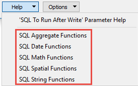 .
.
 to open the editor.
Available menu options depend on the format.
Multiple SQL commands can be delimited by a character specified using the FME_SQL_DELIMITER directive, embedded at the beginning of the SQL block. The single character following this directive will be used to split the SQL block into SQL statements, which will then be sent to the database for execution. Note: Include a space before the character.
For example:
FME_SQL_DELIMITER ;
DELETE FROM instructors ;
DELETE FROM people
WHERE LastName='Doe' AND FirstName='John'
Multiple delimiters are not allowed and the delimiter character will be stripped before being sent to the database.
Any errors occurring during the execution of these SQL statements will normally terminate the reader or writer (depending on where the SQL statement is executed) with an error. If the specified statement is preceded by a hyphen (“-”), such errors are ignored.
This parameter allows for the execution of SQL statements after a set of tables has been written. For example, it may be necessary to clean up a temporary view after creating it.
For detailed information about SQL functions, click the corresponding menu item in the SQL to Run editor help.
to open the editor.Available menu options depend on the format.
Multiple SQL commands can be delimited by a character specified using the FME_SQL_DELIMITER directive, embedded at the beginning of the SQL block. The single character following this directive will be used to split the SQL block into SQL statements, which will then be sent to the database for execution. Note: Include a space before the character.
For example:
FME_SQL_DELIMITER ;
DELETE FROM instructors ;
DELETE FROM people
WHERE LastName='Doe' AND FirstName='John'
Multiple delimiters are not allowed and the delimiter character will be stripped before being sent to the database.
Any errors occurring during the execution of these SQL statements will normally terminate the reader or writer (depending on where the SQL statement is executed) with an error. If the specified statement is preceded by a hyphen (“-”), such errors are ignored.
Enables Load Only mode when Feature Operation is set to Insert.
Load only mode disables the updating of the spatial index while data is loading on a feature class or table, and then rebuilds the indexes.
- Yes (checked) – Load Only mode used for inserts when possible.
- No (unchecked) – Load Only mode used only when creating a new feature class or table.