|
To access feature type parameters, click the gear icon Tip To always display the editor in FME Workbench, you can select View > Window Layout > Parameter Editor.
General All feature types share similar General parameters, which may include Feature Type Name, Reader or Writer information, and Geometry. In most Writer Feature Type parameter dialogs, you can also control Dynamic Schema Definitions. Some database formats accept Table or Index Qualifier prefixes on the output table feature type. |
 on a feature type in the
 Table: General
This parameter specifies how features will be written into the destination table. Supported feature operations are described below. Note that the described behavior can be dependent on the selected options, as well as the underlying table properties.
- More information about Feature Operations.
|
Option |
Description |
If the Row Does Not Exist |
If the Row Exists |
|
Insert |
The writer appends a new row to a table using input feature attributes. |
The writer creates a new row using input feature attributes. |
Not always applicable: if the table does not have a unique key or it has an automatically generated unique key, insertion is always possible. The database cannot violate its key constraints; therefore, errors can occur on row insertion. For example, if there is a unique key and a user specifies the value with the feature, and the feature already exists, then FME Workbench logs an error. This error might be in the form of a rejected feature, or the database may stop processing altogether. |
|
Delete |
The writer deletes an existing row(s) in a table. A selection method must be specified in the Row Selection group. |
The writer rejects the input feature or logs an error if it is unable to continue. |
The writer deletes existing row(s) corresponding to the input feature. |
|
fme_db_ |
The feature operation will be determined by the attribute fme_db_operation on each input feature. A selection method must be specified in the Row Selection group. The value of fme_db_operation will be processed according to the steps below. Note The processing steps listed below depend on a format's available Feature Operation options.
Note about earlier FME versions: To use fme_db_operation, you must set Feature Operation to this option. In previous versions of FME, you could set fme_db_operation when the destination feature type was set to Insert, Update, Upsert, or Delete. Doing this now will cause feature rejection. |
The action depends on the operation; however, in general, if nothing is specified, the value is treated as an Insert. | The value is treated as an Insert. |
Controls how the feature type handles destination tables:
- Use Existing – Write to an existing table If the destination table does not exist, the translation will fail.
- Create If Needed – Create the destination table if it does not exist.
- Drop and Create – (This option is not available in all formats.) Drop the destination table if it exists, and then create it. The writer will drop and re-create the table before writing any features to it. Tables will be overwritten when the first input feature is processed. If no features are sent to a feature type, then the corresponding table will not be overwritten.
- Truncate Existing – (This option is not available in all formats.) If the destination table does not exist, the translation will fail. Otherwise, delete all rows from the existing table.
When inserting into a table, Row Selection is ignored. When updating and deleting from a table (if applicable, based on a format's available Feature Operation options), a condition needs to be specified for selecting which rows to operate on. This parameter group offers two methods to construct the selection condition:
Match Columns
The columns specified in the corresponding column picker dialog will be used for matching destination rows. All matching rows will be selected for update or delete. If any feature attributes corresponding to the specified match columns contain null or missing values, the feature will be rejected.
WHERE Clause
This parameter opens a WHERE Clause Builder. You can also type a WHERE clause inline, without launching the Builder. It is optional to start the clause with the word WHERE.
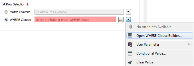
The WHERE Clause Builder makes it easy for users to reference feature attribute values, destination table columns, and invoke FME functions. The WHERE clause is first evaluated as an FME expression, before being passed onto the destination database.
If the WHERE clause is incorrect or if its evaluation results in failure, the translation will fail. Otherwise, if the WHERE clause passes FME evaluation but it is SQL invalid, the feature will be rejected or the translation will fail.
For advanced users, conditional FME expressions created through the Conditional Value editor can be used to create WHERE clauses.
Table Creation
Defines the template which will be used to set up the mosaic dataset. Generic templates will specify band ordering (for example, band name, wavelength, number of bands).
- CUSTOM allows you to specify band ordering in the Product Band Properties table.
- None will have no band ordering.
This parameter is available when the Product Definition is CUSTOM.
Add band definitions and wavelength values, and choose band ordering.
Number of Bands – Specifies the number of bands used. This field is available when the Product Definition is None or CUSTOM.
Pixel Type – Specifies the bit depth, or radiometric resolution of the mosaic dataset. If not defined, it will be taken from the first added raster dataset.
Mosaic Dataset
This parameter specifies the raster type of all rasters to be added. Raster data is added to a mosaic dataset by specifying a raster type, which identifies metadata, such as georeferencing, acquisition date, sensor type, and band wavelengths.
The raster type can be chosen from a predefined list of available raster types. The raster type for raster catalogs/mosaic datasets is Table or Table/Raster Catalog (depending on which ArcGIS version is installed), but both types work interchangeably on all ArcGIS versions.
The selected raster type file (.art or .art.xml) defines the raster type of the rasters which will be added to the mosaic dataset and will overwrite the raster type choice made in Raster Type.
A raster type file contains more detailed raster type information such as processing properties, auxiliary inputs, camera definition, etc. Raster types such as Applanix, ISAT, LAS, LAS Dataset, and Terrain require a raster type file.
Specifies the processing template for the type chosen in Raster Type. A few raster types do not have standard processing templates.
Specifies how duplicate rasters are treated. Valid values are
- Allow Duplicates (default)
- Exclude Duplicates
- Overwrite Duplicates
Mosaic Post Processing
- Update Overviews – Determines whether or not overviews will be defined and generated after all rasters were added. The default is No.
- Update Cell Size Range – Determines whether or not the cell size range for each raster in the mosaic dataset will be calculated. These values are written to the attribute table in the minPS and maxPS columns. The default is Yes.
- Update Boundary – Determines whether or not the boundary polygon of the mosaic dataset is generated. The boundary merges all footprint polygons to create a single boundary. The default is Yes.
These parameters become available when Update Overviews is set to Yes.
Compression Type: – Determines the type of compression to use on overviews. The default is JPEG.
Compression Quality – Describes the degree of lossiness caused by the compression. Valid values are integers from 0 (lowest quality) to 100 (highest quality). This value is ignored when not using one of the JPEG compression types.
Resampling Method – Determines the resampling type to be used when generating reduced resolution overviews on the destination mosaic dataset. Nearest Neighbor is the default value, which provides the fastest output but the poorest quality. Cubic Convolution provides the best quality, but can reduce performance when writing.
Number of Levels – Specifies the number of reduced resolution overviews to build. More overviews enable better performance when viewing raster data using FME and Esri products.
Overview Sampling Factor – Specifies the ratio of the pixel size of the next overview. For example, a cell size of the first level is 10, and the overview factor is 4, then the next overview pixel size is 40.
Base Pixel Size – Specifies a base pixel size at which overviews will be generated. The unit for this parameter is the same as the spatial reference of the mosaic dataset.
Number of Rows – Sets the number of rows for each tile. Larger values result in fewer, larger overviews which increase the likelihood to regenerate lower level overviews. Smaller values result in more, smaller overviews.
Number of Columns – Sets the number of columns for each tile. Larger values result in fewer, larger overviews which increase the likelihood to regenerate lower level overviews. Smaller values result in more, smaller overviews.