FME Form: 2024.1
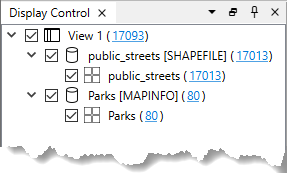
The Display Control shows a list of open datasets and their various feature types. These components are displayed as a hierarchy of levels that can be turned on or off, from entire datasets down to individual feature types.

Hover over each node to display basic information about the data, such as dataset or feature type name, coordinate system, source path, data format, and geometry types.
You can use the Display Control to control how data displays in other windows of the FME Data Inspector.
Displaying Data in the Feature Information Window
Each node in the Display Control shows the number of features represented at that level. To display feature information from each level in the Feature Information window, click the corresponding number. If you apply a filter on the data, the Display Control shows both the number of features that pass the filter and the number of filters that fail the filter. You can click either number to display only those features.
Displaying Feature Types in the View Window
Feature types that include spatial data show a  icon. In 2D mode, you can use the Display Control to adjust the way feature types render in the View window. For example, you can make adjustments to color, opacity, point size, and border width. Click on the icon, or right-click a feature type and select Drawing Style. In the Geometry Drawing Styles dialog, the drawing options available to adjust depend on whether the feature type geometry is an area, line, point, raster, or point cloud.
Also in 2D mode, you can render area feature types without any area filling. Right-click at the level you want to remove area filling (view, dataset, or feature type), and clear Allow Area Filling. This setting overrides any Fill Color or Fill Opacity settings that are applied in the Geometry Drawing Styles dialog.
Additionally, you can adjust the view of a spatial feature type to the full extent of its boundaries. Right-click and select Zoom to Extent.
Displaying Feature Types in the Table View
Feature types that only include non-spatial data show a  icon. To view a feature type (non-spatial or spatial) in the Table View , double-click on the feature type, or right-click and select Show Table.