Using Quick Import
Converts data in any supported format into feature classes.
The geodatabase can then be used, or further post-processing can be performed. Individual feature classes from the staging geodatabase can be operated on using the Select Data tool.
The Quick Import tool does not import Geodatabase topology or relationship feature types.
- Under FME Interoperability Tools in ArcToolbox, choose Quick Import.
The Quick Import dialog appears.
Alternatively, if you created a custom toolbox, you can add the Quick Import selection:
- Right click on the new tool, and choose Tool... from the Add menu:

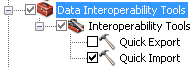
- Check Data Interoperability Tools:
- Click the Browse button
 in the Input Dataset field.
The Specify Data Source dialog appears:
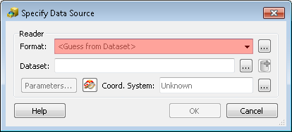
- Select the Source Format
Select the format of your source data. You can also click the Browse button to choose from the Formats Gallery.
- Locate Source Data
Type the location of your input data. You can also use the buttons to browse for files or add multiple datasets. If the source format has specific default settings that you want to change, you can edit them here.
For Parameter Box Help: Press the Help button, the F1 button on your keyboard, or click the Help button in the Parameter box.
- Coordinate System
The
To specify a different coordinate system for the data: Click the Browse button in the Coordinate Systems field to display the Spatial Reference Properties dialog. Refer to the ArcGIS Help for more information on coordinate systems.
- Specify a filename (or use the default) for the output staging geodatabase, and click OK.
A status window appears, which displays information and statistics about the Import function. When the import is complete, you can close the window.
More Information: usage tips, command-line syntax, and scripting syntax.