|
About Database Connections |
|---|
|
Database formats include a Database Connection parameter that defines and stores authentication information. For general information about sharing database connections, please see Using Database Connections. Note that Database Connection parameters differ slightly, depending on context and/or database format. |
|
Connection From the Connection parameter in a database format, you can do one of the following:
|
Database Connection
Connection File
This parameter identifies the pathname of a connection file to be used to connect to an Enterprise Geodatabase.
A connection file provides the necessary information to connect to the SDE server, such as the server name or the username.
The connection file must be a *.sde file and have the proper format for a connection file as defined by Esri. Connection files can be created in ArcCatalog.
Check this option to override the User and Password from the connection file. Overriding credentials is required for Connection Files that do not have saved credentials.
Note: This parameter is ignored if the Connection File is using OS Authentication.
Username and Password
Enter the username and password to access the service.
Constraints
Tables
After specifying the database connection, click the Browse button (...) to select tables for import. A connection window appears while the system retrieves the tables from the database.
Once the Select Tables dialog appears, you can select one or more tables. Click OK to dismiss the window and add the selected table name(s) to the Tables parameter.
WHERE Clause
An SQL WHERE clause can be applied to the selected tables, to constrain the row selection in tables chosen in the table list (for example, NUMLANES=2).
Alias Mode
This parameter controls how Geodatabase aliases are used.
- None – Aliases are ignored.
- Replace Attribute Names with Aliases – (only applicable when adding a Reader) Attributes on feature types will be named for their aliases rather than their official names. A geodb_feature_class_alias attribute will be included on each feature. Use this mode when the target format should create feature types using the aliases as attribute names.
- Expose Aliases as Metadata Attributes – For each attribute read, a second <name>_alias attribute will be added that stores the alias for the attribute in question. A geodb_feature_class_alias attribute will also be included on each feature. Use this mode when the target format is Geodatabase and the aliases should be preserved during feature class and table creation.
Additional Attributes to Expose
Use this parameter to expose Format Attributes in Workbench when you create a workspace:
- In a dynamic scenario, it means these attributes can be passed to the output dataset at runtime.
- In a non-dynamic scenario, this parameter allows you to expose additional attributes on multiple feature types. Click the browse button to view the available format attributes (which are different for each format) for the reader.
Using the minimum and maximum x and y parameters, define a bounding box that will be used to filter the input features. Only features that intersect with the bounding box are returned. (Note that this is the bounding box intersection only, and not a full geometry intersection that would be returned by a transformer like the SpatialFilter.)
If all four coordinates of the search envelope are specified as 0, the search envelope will be disabled.
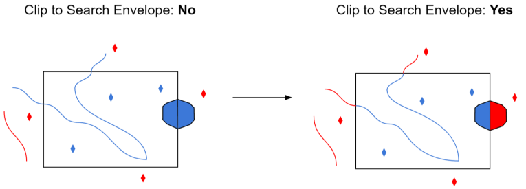
Clip to Search Envelope
When selected, this parameter removes any portions of imported features being read that are outside the Search Envelope.
The example below illustrates the results of the Search Envelope when Clip to Search Envelope is not selected (set to No) and when it is selected (set to Yes).
- No: Any features that cross the search envelope boundary will be read, including the portion that lies outside of the boundary.
- Yes: Any features that cross the search envelope boundary will be clipped at the boundary, and only the portion that lies inside the boundary will be read. The underlying function for the Clip to Search Envelope function is an intersection; however, when Clip to Search Envelope is selected, a clipping operation is also performed in addition to the intersection.
Advanced
When enabled, the database connection persists for the duration of an FME session.
For example, it may be desirable to maintain a connection when running a batch of 100 workspaces on the same database connection, which saves the processing time required to make and break a database connection.
FME considers the database connection to be the same when the database name, the username, and password are the same.
Managed rasters, rasters stored within the Geodatabase, represent nodata as a bit mask on each band. This parameter specifies how to handle these nodata bit masks.
- None – Nodata bit masks will be ignored
- Single Alpha Band (default) – Nodata bit masks for each band are merged into a single additional alpha band named geodb_nodata.
If merged into a single alpha band, then the alpha band will contain a value of 0 (nodata) at a given cell if and only if the corresponding cell of all the other bands is nodata.
This parameter only affects managed rasters. Unmanaged rasters, rasters stored in files outside the Geodatabase, have nodata represented as a nodata value per band and do not have nodata bitmasks.