Extracts the geometry properties of a point cloud feature and exposes them as attributes, optionally checking for their existence, retrieving component properties, and finding minimum and maximum values. Extents may also be recalculated and updated.
Typical Uses
- Extracting basic information about a point cloud feature, such as geographic extents, number of points, and intensity ranges.
- Calculating and updating point cloud extents after operations such as merging, clipping, or filtering that may affect their overall dimensions.
-
Accessing component information such as encoding and data type, so that further manipulation of these values can be more easily done.
How does it work?
The PointCloudPropertyExtractor receives point cloud features and extracts basic information about their geometry. The results are added as attributes, and output with the original feature.
A selection of Components is available, which may or may not exist on the point cloud. For each component included, you may check to see if it does exist (yes or no), retrieve its properties, and/or extract its minimum and maximum values. If Check Existence is used, and the chosen property does not exist on the point cloud feature, attributes will not be added for that component’s Properties or Min/Max values.
The number of points in the point cloud feature will always be included, as the attribute _num_points.
Available components include:
- x
- y
- z
- intensity
- color_red
- color_green
- color_blue
- classification
- return
- number_of_returns
- angle
- flight_line
- scan_direction
- point_source_id
- posix_time
- user_data
- gps_time
- gps_week
- flight_line_edge
- normal_x
- normal_y
- normal_z
Note: The extracted attribute values reflect the state of the point cloud at the time of extraction, and may become out of date if the point cloud properties change.
Calculate and Update Extents
A point cloud’s component values are static, and so must be explicitly updated to reflect changes.
This parameter may be used to update the extents (x, y, and z) of the point cloud feature after splitting, merging, or other operations that alter the bounding dimensions of the feature. The update is performed prior to the value extraction, and so the results will reflect updated extent values.
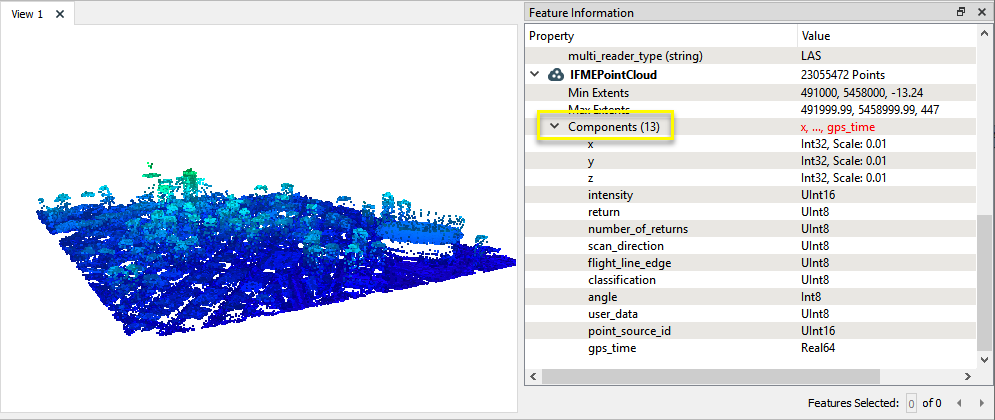
In this example, we will extract selected properties from a point cloud. The source is a tile of LiDAR data in downtown Vancouver, where we can clearly see tall buildings and a stadium.
Note that the point cloud has a number of Components, and we can view limited information about those components.
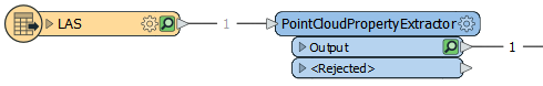
The point cloud is routed into a PointCloudPropertyExtractor.
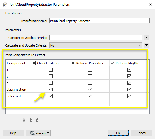
In the parameters dialog, we select which information to extract by configuring the Point Components To Extract table.
The x, y, and z components are included by default (though can be removed). We add two additional components to include - classification and color_red.
Note that for both of these additional components, we have enabled the Check Existence parameter, which will check to see if the requested component exists on the feature, and return a Yes/No answer. If the component does not exist, it will return No, and will not add any additional attributes for that component.
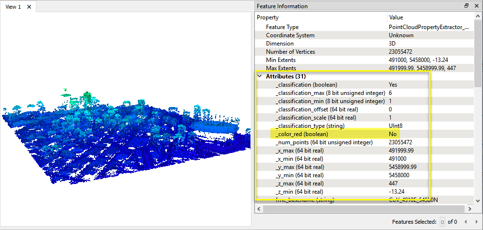
New attributes are added to the output feature, containing the requested components, properties, and minimum/maximum values.
Note that checking for the existence of the color_red component returned No, and so no further attributes were added for that component.
In this example, we start with the same LiDAR dataset as the previous example. Note the display coloring as shown in the FME Data Inspector, which renders point clouds that do not have color components using a rainbow gradient. Blue represents the lowest points, moving through the spectrum to red at the highest points.
This point cloud is shown as predominantly blue - an indication that there may be some high, invalid points that should be removed.
Note that the Max Extents z value is 447.
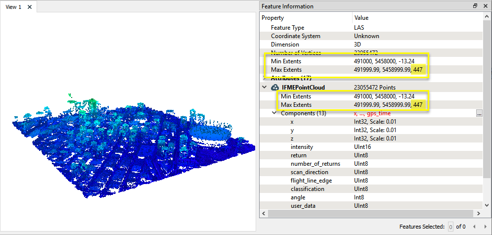
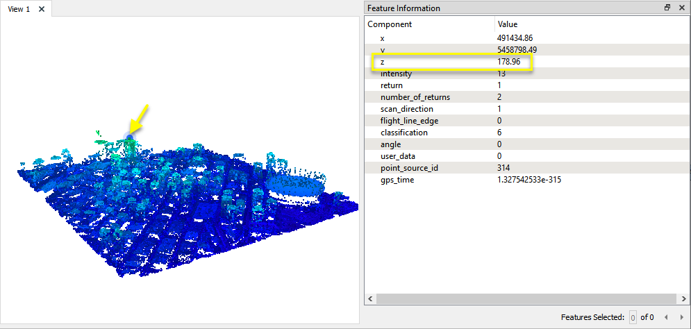
Examining the tops of the tallest structures, the highest valid z values appear to be less than 200.
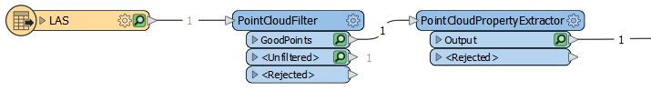
The point cloud is routed first into a PointCloudFilter, and then on to a PointCloudPropertyExtractor.
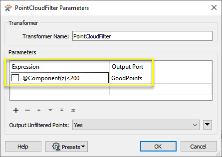
In the PointCloudFilter parameters dialog, one expression is created, sending all points with a z value of less than 200 to the GoodPoints output port.
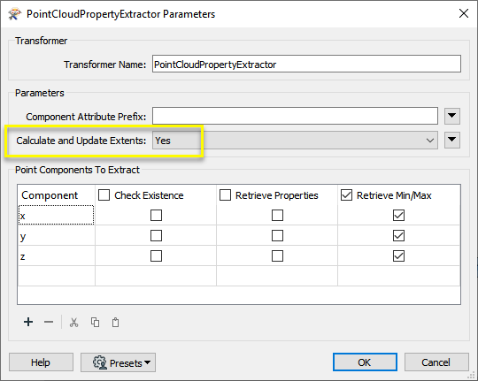
In the PointCloudPropertyExtractor parameters dialog, Calculate and Update Extents is set to Yes.
Note that the x, y, and z component minimum and maximum values will also be extracted.
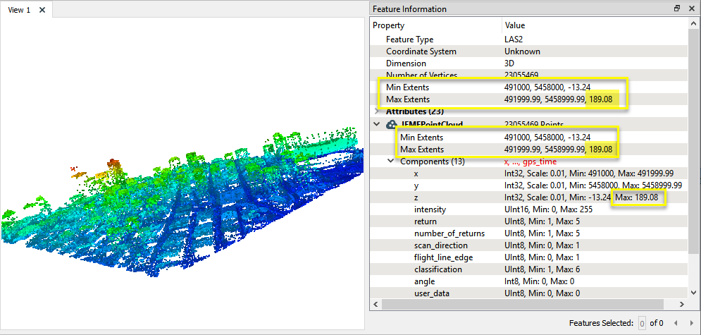
The output point cloud feature reflects a more even color gradient distribution, and the newly calculated maximum z value is 189.08.
Usage Notes
- To access similar information about individual points, use the PointCloudCoercer to convert the point cloud feature to points.
Choosing a Point Cloud Transformer
FME has a selection of transformers for working specifically with point cloud data.
For information on point cloud geometry and properties, see Point Clouds (IFMEPointCloud).
|
PointCloudCoercer |
Coerces point cloud geometries into points or multipoints. |
|
PointCloudCombiner |
Combines multiple geometries into a single point cloud. Point cloud features will be accumulated as is. PointCloudCombiner is often used to accumulate multiple point clouds into a single point cloud feature, but can also convert other geometries into point clouds and merge them. |
|
PointCloudComponentAdder |
Adds new components with constant values to a point cloud. |
|
PointCloudComponentCopier |
Copies an existing component to a new component with the specified name. The existing component remains and a new component is created that has a different name, but the same values. |
|
PointCloudComponentKeeper |
Removes all components from a point cloud, except for the specified ones. |
|
PointCloudComponentRemover |
Removes specified components from a point cloud. |
|
PointCloudComponentRenamer |
Renames an existing component. |
|
PointCloudComponentTypeCoercer |
Converts the type of point cloud components. |
|
PointCloudConsumer |
Requests the point(s) from the point cloud geometry but no actual operations are performed on the point(s). |
|
PointCloudCreator |
Creates a new point cloud feature with the specified size and components and sends it into the workspace for processing. |
|
PointCloudExpressionEvaluator |
Evaluates expressions, such as algebraic operations or conditional statements, to set point cloud component values. |
|
PointCloudExtractor |
Serializes the geometry of the feature into the Blob Attribute based on the selected writer format. |
|
PointCloudFilter |
Filters a point-cloud feature into one or more parts, output via separate ports, based on evaluating expressions. |
|
PointCloudMerger |
Merges component values from one point cloud to another. Features that contain the desired components are connected through the Supplier port, and the features that will receive the components are connected through the Requestor port. |
|
PointCloudOnRasterComponentSetter |
Sets point cloud component values by overlaying a point cloud on a raster. The component values for each point will be set from band values at the point location. |
|
PointCloudPropertyExtractor |
Extracts the geometry properties of a point cloud feature and exposes them as attributes, optionally checking for their existence, retrieving component properties, and finding minimum and maximum values. Extents may also be recalculated and updated. |
|
PointCloudReplacer |
Replaces the geometry of the feature with the geometry held in the Blob Attribute. The blob is decoded according to the selected point cloud format. |
|
PointCloudSimplifier |
Reduces the number of points in a point cloud by selectively keeping points based on the shape of the point cloud. The simplified and removed points are output as two discrete point clouds. |
|
PointCloudSorter |
Sorts a point cloud by the values of components. |
|
PointCloudSplitter |
Splits a single point cloud feature into multiple point cloud features, each having a homogeneous value for the point component that governs the split. |
|
PointCloudStatisticsCalculator |
Calculates statistics on point cloud components and adds the results as attributes. |
|
PointCloudSurfaceBuilder |
Takes an input point cloud and reconstructs it into an output mesh. |
|
PointCloudThinner |
Reduces the number of points in (thins) a point cloud by keeping points at a fixed interval, a maximum number of points, or a set quantity of first or last points. Remaining points are discarded. |
|
PointCloudTransformationApplier |
Applies transformations on a point cloud. Applying a transformation is primarily done for compatibility with other processing and writers that cannot support the transformation natively. For example, the LAS reader produces Int32 coordinates with a scale and offset. However, the POINTCLOUDXYZ writer cannot support component scale/offsets, so the transformation will be applied. The resulting coordinates will be Real64 with no transformation. Note that processing and writers that cannot support transformations will apply them automatically, but this transformer can be used to manually apply the transformation if desired. |
Configuration
Input Ports
This transformer accepts only point cloud features.
Output Ports
Point cloud features with attributes containing component properties as specified.
Output features may also have updated extents values.
Non-point cloud features will be routed to the <Rejected> port, as well as invalid point clouds.
Rejected features will have an fme_rejection_code attribute with one of the following values:
INVALID_GEOMETRY_TYPE
Rejected Feature Handling: can be set to either terminate the translation or continue running when it encounters a rejected feature. This setting is available both as a default FME option and as a workspace parameter.
Parameters
| Component Attribute Prefix | (Optional) A prefix to add to attributes related to point cloud components. |
| Calculate and Update Extents |
If Yes, all the points of the point cloud will be read, and the point cloud extents will be updated to their exact values. The extents of a point cloud may change after certain operations (for example, clipping). When this happens, the extents are typically set to an approximation of the true bounds (for example, when clipping, the output point cloud bounds are equal to the intersection of the input point cloud bounds and the clipper bounds). |
This table is used to specify the components for which to extract properties, and which properties to extract for each component.
The x, y, and z components are included by default, and may be removed.
The number of points will always be extracted into the attribute _num_points.
| Component |
Any or all of the following components may be requested:
|
||||||||
| Check Existence |
If enabled, the following properties will be extracted:
Note that if a requested component does not exist, only the existence check attribute (_<component>) will be set. All other attributes will be ignored. |
||||||||
| Retrieve Properties |
If enabled, the following properties will be extracted:
|
||||||||
| Retrieve Min/Max |
If enabled, the following properties will be extracted:
|
Editing Transformer Parameters
Using a set of menu options, transformer parameters can be assigned by referencing other elements in the workspace. More advanced functions, such as an advanced editor and an arithmetic editor, are also available in some transformers. To access a menu of these options, click  beside the applicable parameter. For more information, see Transformer Parameter Menu Options.
Defining Values
There are several ways to define a value for use in a Transformer. The simplest is to simply type in a value or string, which can include functions of various types such as attribute references, math and string functions, and workspace parameters. There are a number of tools and shortcuts that can assist in constructing values, generally available from the drop-down context menu adjacent to the value field.
Using the Text Editor
The Text Editor provides a convenient way to construct text strings (including regular expressions) from various data sources, such as attributes, parameters, and constants, where the result is used directly inside a parameter.
Using the Arithmetic Editor
The Arithmetic Editor provides a convenient way to construct math expressions from various data sources, such as attributes, parameters, and feature functions, where the result is used directly inside a parameter.
Conditional Values
Set values depending on one or more test conditions that either pass or fail.
Parameter Condition Definition Dialog
Content
Expressions and strings can include a number of functions, characters, parameters, and more.
When setting values - whether entered directly in a parameter or constructed using one of the editors - strings and expressions containing String, Math, Date/Time or FME Feature Functions will have those functions evaluated. Therefore, the names of these functions (in the form @<function_name>) should not be used as literal string values.
| These functions manipulate and format strings. | |
|
Special Characters |
A set of control characters is available in the Text Editor. |
| Math functions are available in both editors. | |
| Date/Time Functions | Date and time functions are available in the Text Editor. |
| These operators are available in the Arithmetic Editor. | |
| These return primarily feature-specific values. | |
| FME and workspace-specific parameters may be used. | |
| Creating and Modifying User Parameters | Create your own editable parameters. |
Reference
|
Processing Behavior |
|
|
Feature Holding |
No |
| Dependencies | None |
| FME Licensing Level | FME Professional Edition and above |
| Aliases | |
| History | |
| Categories |
FME Community
The FME Community is the place for demos, how-tos, articles, FAQs, and more. Get answers to your questions, learn from other users, and suggest, vote, and comment on new features.
Search for all results about the PointCloudPropertyExtractor on the FME Community.
Examples may contain information licensed under the Open Government Licence – Vancouver