Specification Variant
This indicates which GDF specification will be used when creating the output GDF file. Several GDF data producers do not strictly follow the official CEN GDF 3.0 standard, but rather follow their own slightly modified version of these standards. If you know the specification your file uses, you can indicate it here. If not, FME will make its best effort to determine the specification.
Tells the GDF reader to use an intelligent guess as to which specification to use, based on the header of the GDF file it is overwriting, if any.
The official CEN 3.0 specification is used.
The NavTech variant of the GDF specification is used.
The TeleAtlas variant of the GDF specification is used.
Geometry Completion
Indicates the level up to which the user wants to complete the geometry. All levels above this will have the geometry linked to the features indirectly. All levels with complete geometry will have the geometry explicitly on each feature directly.
When FME reads GDF files, it requires a lot of effort to store and reference all the features between layers. For example, to get the geometry of a single level 2 feature, first the FME must locate all the level 1 features that are linked to it. Then it has to locate all the level 0 features that are linked to each Level 1 feature. Then it has to locate all the XYZ features that are linked to every Level 0 feature. Finally it has to put all that geometry together and process it to generate the geometry for the single level 2 feature. It is much easier if the features were output with no geometry but instead kept attributes that indicated to which other features it was linked.
For this reason, there is an option of choosing whether features produced by the reader have the "links" on them, or if the FME should to go through all the effort to complete the links and form the geometry on each feature. There is also the option of specifying on which levels the geometry should be completed, and which levels will be left as "linked" to lower-level features.
For example, if you were only interested in the level 1 features of a GDF dataset (you were going to delete or ignore the level 2 features) then there would be no reason for FME to complete the geometry on level 2 features. You could choose to complete only the geometry on level 1 features and leave the level 2 features as linked (since you would be deleting them anyway).
Another example might be if you are planning to import features into a spatial database. In your new model, you would like to keep the links present so that if you edited and modified the geometry of a level 0 feature, the geometry of all level 1 and 2 features that link to it would immediately change. In this situation, you would select NONE for geometry completion, and just import all the features into your database as linked.
Of course, if you are translating GDF to any of the more common file-based formats for general viewing and usage, completing the geometry all the way up to level 2 is probably the most reasonable choice.Determines if geometry links are resolved to build geometry on higher level features.
Attributes
Indicates whether to complete the attribute links for each feature. If checked, all features will have their attributes explicitly appear on the features directly. If not checked, all features will have their attribute information remain in separate tables joined with link values.
The issues surrounding attribute completion when reading GDF is similar to geometry completion. Natively, a feature’s attributes are referenced through a linking mechanism and extra effort is needed if it is desired that the features read from GDF know all their attributes directly.
Therefore there is an option of choosing between whether features produced by the reader have the "links" on them or if FME should to go through all the effort to complete the links and supply the attributes directly on each feature as they are read. Reasoning as to whether or not to choose attribute completion is similar to that outlined for geometry completion.
Indicates if the user wants attribute features that have been used in attribute completion to be output by the reader. If this box is checked, then features that primarily carry attribute values (for example GDF Name records) will be output. This parameter has no effect if the Attribute Completion setting is not checked.
Code
Indicates whether known codes of attribute names are replaced with their actual expanded name for each feature. If selected, all features will have the code values of their attribute names replaced. For example, an attribute ON will be renamed to Official Name. If this option is not enabled, all features will have their attribute names left as the original codes.
Indicates whether known codes of attributes are replaced with their actual expanded values for each feature. If selected, all features will have the code values of their attributes replaced. For example, an attribute Vehicle Type with the value 16 will have that value replaced by Taxi. If this option is not enabled, all features will have their attribute values left as the original codes.
Metadata Options
Indicates whether the reader should to ignore the FIELDEFREC (03) and RECDEFREC (04) records in the GDF file, or parse and honor them. If you check this option, all FIELDEFREC (03) records and RECDEFREC (04) in the file will be ignored when reading. This is useful for reading files with corrupt metadata. Without ignoring these corrupt lines, the file could not be read correctly. However, if the dataset is encoded in a schema different from the default one provided by the reader and the FIELDEFREC (03) and RECDEFREC (04) records for that dataset are corrupted, it will be impossible for the reader to read the dataset.
Multiple Value Separator
Specifies the characters that will separate values when an attribute has more than one value. The multiple value separator can be any string. For instance, the Name attribute of a Country may have two values: Japan and Nippon. If the ":::" separator is specified, the value for Name will be Japan:::Nippon.
Schema Attributes
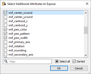
Use this parameter to expose Format Attributes in Workbench when you create a workspace:
- In a dynamic scenario, it means these attributes can be passed to the output dataset at runtime.
- In a non-dynamic scenario where you have multiple feature types, it is convenient to expose additional attributes using this one parameter. For example, if you have ten feature types and want to expose the same attribute in each one, it is easier to define it once than it is to set each feature type individually in the workspace.

Using the minimum and maximum x and y parameters, define a bounding box that will be used to filter the input features. Only features that intersect with the bounding box are returned.
If all four coordinates of the search envelope are specified as 0, the search envelope will be disabled.
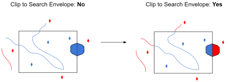
When selected, this parameter removes any portions of imported features being read that are outside the Search Envelope.
The example below illustrates the results of the Search Envelope when Clip to Search Envelope is not selected (set to No) and when it is selected (set to Yes).
- No: Any features that cross the search envelope boundary will be read, including the portion that lies outside of the boundary.
- Yes: Any features that cross the search envelope boundary will be clipped at the boundary, and only the portion that lies inside the boundary will be read. The underlying function for the Clip to Search Envelope function is an intersection; however, when Clip to Search Envelope is selected, a clipping operation is also performed in addition to the intersection.
