By default, FME chooses a coordinate system for destination data sets according to the rules specified in How FME Processes Coordinate Systems in the Workspace. Alternatively, you can direct FME to reproject data to a destination coordinate system that you specify.
To specify a reprojection, do one of the following:
- In the FME Workbench Navigator, specify the writer coordinate system.
- Use a transformer that reprojects features to a specified coordinate system.
When using the FME Workbench Navigator, you specify only the coordinate system name, and FME performs an implicit conversion using the CS-MAP library. To perform the conversion, FME selects a "best-guess" datum transformation, using an algorithm based on the source and destination coordinate systems.
When using a transformer, you perform an explicit conversion, which gives you more control over which reprojection engine to use (CS-MAP, Esri, and others), which datum to use, and other parameters. For more information about transformers that perform explicit conversion, see the FME Transformers help, under "Coordinate Systems."
Note: The Reprojector transformer does not provide the option of specifying a datum, and is considered an "implicit" conversion.
When choosing between implicit and explicit reprojection, keep in mind the following:
- Using a transformer to reproject data is necessary when working with multiple datasets that have different coordinate systems, and your workspace requires that their features interact geographically before they are written out. This is because in implicit conversion, reprojection does not occur until just before features are written out.
- Using explicit reprojection with data formats that specify coordinate systems in feature attributes may lead to unexpected results. Using implicit reprojection is recommended in these cases.
- When using implicit reprojection, the datum transformation that is selected by default may change between product releases.
See Also
Using the Workspace Navigator to Convert to a Different Coordinate System
- Create a workspace, and define your reader and writer.
- In the source dataset area in the Navigator pane, the Coordinate System parameter will be displayed as <not set>. This means that FME will either use default values, or will read the coordinate system from the source data.
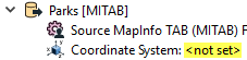
You can explicitly set the source coordinate system (which will override any coordinate system read from the source) but in most cases, you will not need to change the default parameter.
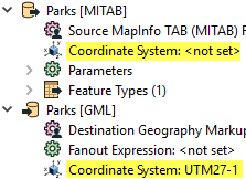
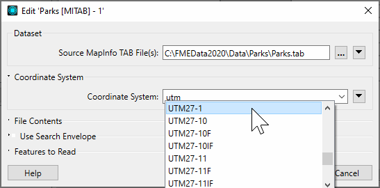
- In the destination dataset area of the Navigator pane, double-click the Coordinate System parameter.
- In the dialog that appears, you can either click the Browse button to display the Coordinate System Gallery or enter a prefix or character string that will display a list of matching selections. For example, if you type the string "UTM" you will see these matches:
FME will reproject the data to the coordinate system that you enter in this field, and the Navigator pane will display something similar to this: