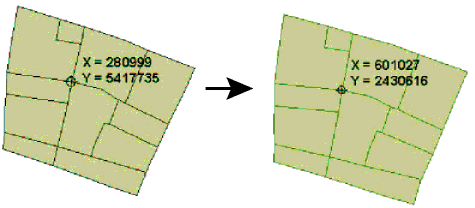
If the feature had a coordinate system, that system is used as the source of the reprojection, and the Source Coordinate System parameter to this transformer is ignored.
If the feature did not have a source coordinate system, and the Source Coordinate System parameter was unset, then the transformer only sets the coordinate system of the feature to the destination coordinate system, and the coordinates of the feature remain unchanged.
Note: If the source coordinate system is not fixed and may change from feature to feature, and the features themselves have been tagged with a coordinate system from the reader that produced them, then a single Reprojector may still be able to be used. In such a case, both the source and destination coordinate system can be set to the same value – the destination coordinate system – and the desired behavior will be accomplished.
The Interpolation Type affects only raster data. Cell values are interpolated in order to change the raster to the specified size.
The Cell Size applies only to raster features.
Sets the tolerance, in cells, for approximating cell locations for raster reprojection.
If a value of 0.0 is specified, every cell location in the raster will be reprojected. This is the default.
If a value > 0.0 is specified, rather than reprojecting every single cell location in the raster, some cell locations will be approximated. The difference between an approximated cell location and the true cell location should be at most the tolerance value. For example, if a value of 0.5 is specified, each approximated cell location should be at most half a pixel away from its true location. Specifying a value > 0.0 may improve performance.
If the destination coordinate system is specified as "_AZMEA_" or "_AZMED_", each input feature is reprojected to either an equal area or equal distance projection appropriate for that feature, respectively. In general, this causes a new coordinate system to be defined for each input feature.
Each feature remembers which specific equal distance or equal area coordinate system it has, and can be safely reprojected back to a normal (non-dynamic) coordinate system.
As an example:
Note: Note that the source is ignored here. We just chose _AZMED_ to help remember what is going on. Sometimes people prefer to set the source and destination both to LL-WGS84.
Dynamic coordinate systems have the following limitation:
• Z is not considered, so areas or distances are best preserved for geometry at an ellipsoid height of 0 meters.
Using a set of menu options, transformer parameters can be assigned by referencing other elements in the workspace. More advanced functions, such as an advanced editor and an arithmetic editor, are also available in some transformers. To access a menu of these options, click beside the applicable parameter. For more information, see Transformer Parameter Menu Options.
Associated FME function or factory: @Reproject
Search for samples and information about this transformer on the FME Community.
Keywords: pointcloud