Licensing options for this format begin with FME Professional Edition.
FME can read Geohashes with the Geohash Reader.
Overview
The purpose of the geohash.org service is to offer short URLs that uniquely identify positions on the Earth, so that referencing them is more convenient.
Geohash is a latitude/longitude geocode system that stores geometry in a hash. It is a hierarchical spatial data structure that subdivides space into areas called buckets of grid shape. Each of these buckets is then subdivided into smaller buckets. The size of the bucket is inversely proportional to the length of the hash: a longer hash means a smaller bucket, and a more precise location.
Supported geometries include points and polygons.
The given geohash will be decoded into its approximate latitude and longitude coordinates, presented as a rectangular polygon. A point is also placed at the center of this polygon with latitude and longitude coordinates for easy access.
For more information about Geohash, please see: http://en.wikipedia.org/wiki/Geohash.
Reader Overview
The Geohash reader produces FME features for all feature data held in a Geohash file. It extracts features one at a time from the file and passes them on to the rest of FME for further processing.
Writer Overview
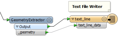
Writing to a Geohash is possible through a combination of the GeometryExtractor transformer and the Writer Overview
Connecting a Text File Writer
- Load source data into a workspace using the appropriate readers.
- Place a GeometryExtractor transformer.
- Open the transformer parameters and set Geometry Encoding to Geohash.
- Add and connect to a Text File writer.
- Connect the GeometryExtractor's _geometry attribute to the Text File writer's text_line_data attribute.
Note: This will generate a geohash for each feature. The geohash represents a point at the center of the feature with an associated area of precision.